Are we accurately estimating the potential role of pollution in the decline of species at risk in Canada?
Abstract
Pollution is a pervasive, albeit often invisible, threat to biodiversity in Canada. Currently, the Committee on the Status of Endangered Wildlife in Canada (COSEWIC) relies on expert opinion to assess the scope (i.e., the proportion of a species’ population that may be affected) of pollution to species at risk. Here, we describe a spatially explicit, quantitative method for assessing the scope of pollution as a threat to species at risk in Canada. Using this method, we quantified the geographic co-occurrence of 488 terrestrial and freshwater species and pollution sources and determined that, on average, 57% of the mapped occurrences of each species at risk co-occurred with at least one pollution source. Furthermore, we found a weak correlation between the scope of the threat of pollution as assessed by COSEWIC expert panels and the geographic overlap of species occurrences and pollution sources that we determined with our quantitative method. Experts frequently identified scope of pollution as absent or negligible even for species with extensive co-occurrence with pollution sources, especially vascular plants. Clearly, a quantitative approach is needed to make accurate estimates of the scope of pollution as a threat to species at risk in Canada.
Introduction
Pollution of the air, soil, and water is a significant threat to many species (Novacek and Cleland 2001; Dudgeon et al. 2006; Hernández et al. 2016). In some cases, pollution can cause sudden and immediate mortality, such as an oil spill leading to massive kills of birds (e.g., Haney et al. 2014) or wildlife deaths after contact with cyanide-bearing wastes from gold mining (Donato et al. 2007). Similarly, nutrient pollution can lead to rapid mortality of fish or waterfowl as a result of the production of potent toxins in algal blooms (e.g., Papadimitriou et al. 2018) or upwelling of anoxic bottom waters (e.g., Rao et al. 2014). However, many pollutants cause sublethal effects on wildlife that are less obvious and more challenging to assess (Nilsen et al. 2019). Nonetheless, sublethal effects of environmental pollutants on individuals can reduce their fitness, leading to population-level impacts (e.g., Kidd et al. 2007; Incardona et al. 2015). Notably, pollutants not only have direct toxic effects on organisms, but may also potentially cause harm through indirect pathways (e.g., trophic cascades; Kidd et al. 2014; Sasaki et al. 2016). Pollution can also compound the effects of other drivers of decline, weakening populations already affected by loss of habitat, overexploitation, or other threats (Brook et al. 2008; Darling and Côté 2008).
The task of assessing the effects of pollution is daunting: tens of thousands of chemicals exist in commerce today and the size of the global chemical industry is projected to double by 2030 (UNEP 2019). Contaminants, such as certain flame retardants, undergo transformations into more toxic breakdown products in the environment that contribute to heightened environmental effects (Liggio et al. 2016). For many pollutants there are no analytical methods to detect their presence in either the environment or wildlife, or detection methods may be costly and invasive (Choy et al. 2010). Most chemical substances available in commerce are not monitored in the air, soil, or water (Muir and Howard 2006).
Numerous sources of pollution are of concern to Canada’s biodiversity. On an annual basis, about 5 million tonnes of pollutants, including over 320 substances, are released to the environment from more than 7000 facilities across Canada (Government of Canada 2018). These include pollutants released into the air, land, and water from oil and gas extraction, manufacturing, mining, quarrying, electricity, and other sectors, including municipal wastewater treatment plants (Government of Canada 2018). Over 2000 wastewater facilities across the country contribute to the over 150 billion litres of untreated and undertreated sewage that is discharged into Canadian waterways every year (Government of Canada 2017a). In addition to these intentional discharges, pipeline and other transportation incidences result in the accidental release of pollutants to the environment. For example, close to 700 pipeline spills over the last decade resulted in the release of natural gas, crude oil, and other substances to the Canadian environment (National Energy Board 2019). Runoff from urban, agricultural, and industrial landscapes contaminates Canada’s groundwater and downstream aquatic ecosystems (Government of Canada 2017b). Finally, over 23 000 known or suspected contaminated sites have been identified and classified in urban, rural, and remote areas across Canada, many of which are contaminated with petroleum hydrocarbons, metals, and (or) persistent organic pollutants, such as polychlorinated biphenyls (Government of Canada 2017c).
To standardize the consideration of threats during species assessments, the International Union for the Conservation of Nature (IUCN) developed a threat classification system. Categories include anthropogenic threats such as Residential and Commercial Development, Agriculture and Aquaculture, Energy Production and Mining, and Pollution (Salafsky et al. 2008; IUCN 2019). In Canada, the IUCN’s threat classification system has been adopted by the Committee on the Status of Endangered Wildlife in Canada (COSEWIC) in an effort to standardize federal species assessments. COSEWIC is an independent committee of experts charged with determining which species are at risk of extinction in Canada and re-assessing the status of each species at risk once every 10 years (Government of Canada 2016a). The scope and severity of each threat are considered independently; both are critical to accurately assess the impact of a threat on the target population. Scope estimates the proportion of the species’ population that can reasonably be expected to be affected by the threat within the next 10 years (NatureServe 2019a; Table 1). Severity represents the likely impact of each threat on the size of the population within 10 years, or three generations of the species, whichever is longer (NatureServe 2019a). Thus, a threat with high scope and high severity affects most individuals of the species and is likely to cause substantial declines. A threat with high scope and low severity affects most individuals of a species but is unlikely to cause the population to decline.
Table 1.
| Scope | Definition |
|---|---|
| Pervasive | Affects all or most (71%–100%) of the total population or occurrences |
| Large | Affects much (31%–70%) of the total population or occurrences |
| Restricted | Affects some (11%–30%) of the total population or occurrences |
| Small | Affects a small (1%–10%) proportion of the total population or occurrences |
| Negligible | Affects a negligible (<1%) proportion of the total population or occurrences |
In Canada, species assessments are conducted by panels of experts in the biology of particular taxa. The members of these panels work together to complete a “Threats Calculator”, which quantifies the scope and severity of each category of threat. The accuracy of a species assessment relies on the available data, but complete “gold standard” data sets for most species and threat categories are lacking (Joppa et al. 2016). Species experts are well qualified to assess the ecological needs or population trends of their study species. However, these experts may not necessarily have expert knowledge of all threat categories, or of the ways in which each threat is most likely to affect their study species. In the experience of some of us who have served on COSEWIC committees, the lack of data available for assessing the scope of pollution in particular became painfully clear, which led us to wonder: how accurately is the scope of pollution as a threat to Canadian species at risk currently being assessed and, furthermore, could accuracy be improved by a rigorous, quantitative method?
In this study, we quantified the scope of pollution threat as the extent of geographic overlap between point sources of pollution and the distributions of Canadian species at risk. We then compared our estimate of scope with the scope of pollution listed in the Threats Calculators completed using expert opinion through the COSEWIC process. Our goals were to determine: (i) what proportion of the observed distribution of each species at risk coincides with conservatively mapped sources of pollution, (ii) the geographic or taxonomic patterns in pollution and distribution co-occurrence, and (iii) the extent to which Threats Calculator estimates of scope correspond to the geographical co-occurrence of pollution sources and species. We do not address the severity of pollution as a threat to Canadian species at risk, as this would require data that, in most cases, are simply not available. However, our results provide a tool to estimate the minimum scope of exposure to pollutants for species assessed or re-assessed in the future.
Methods
Species assessments
To document the current understanding of pollution as a threat to species at risk in Canada, we reviewed Status Reports and Threats Calculators for each species listed as endangered, threatened, or special concern by COSEWIC. A Status Report is commissioned before assessment or re-assessment of each species and outlines the best available information on the species’ biology, population trends, life history, distribution in Canada, and threats (Government of Canada 2016b). As of November 2015, each species assessment also includes a Threats Calculator that follows a standardized system (described above). The Threats Calculator is completed by a panel of species experts and representatives from relevant jurisdictions, during a discussion of the threats. Each threat type is subdivided into second-level threat categories in the threat classification system (e.g., 9.5 Air-Borne Pollutants; see Salafsky et al. 2008 and Table 2) and the panel must agree on the scope and severity of each threat category. Scores for scope and severity are then combined to determine the overall impact of each threat category on the species.
Table 2.
| Category | Description | Spatial data sources used |
|---|---|---|
9.1 Household Sewage and Urban Waste Water | Waterborne sewage and nonpoint runoff from housing and urban areas that include nutrients, toxic chemicals, and (or) sediments | 1. Built-up areas: a populated zone where buildings are so close together that, for cartographic purposes, they are represented by a built-up area outline (polygons; DMTI Spatial Inc. 2015). 2. Sewage ponds: compiled from the industrial and resource layer provided by DMTI (DMTI Spatial Inc. 2014). Includes only polygons labeled as Liquids depot/dump: Liquid waste, sewage disposal pond. |
9.2 Industrial and Military Effluents | Waterborne pollutants from industrial and military sources including mining, energy production, and other resource extraction industries that include nutrients, toxic chemicals | 1. National Energy Board reported pipeline incidents, 2008–2016. Point locations of incidents involving the release of a liquid or that have adverse environmental effects. Publicly available at neb-one.gc.ca/sftnvrnmnt/sft/dshbrd/mp/index-eng.html. 2. Mines and quarries: compiled from the industrial and resource layer provided by DMTI (DMTI Spatial Inc. 2014). Includes only polygons labeled as Mining area: Pit, open pit, operational, OR Mining area: Mine, open pit, operational, OR Mining area: Quarry, open pit, operational. Abandoned mines not included. 3. National Pollutant Release Inventory releases to water or land. Publicly available at canada.ca/en/services/environment/pollution-waste-management/national-pollutant-release-inventory.html. We downloaded the data for 1994–2016 reported releases and mapped the locations of the reporting facilities. We excluded releases <1 tonne that were not distinguished between air, land, or water, and we excluded releases where the quantity released was 0. |
9.3 Agricultural and Forestry Effluents | Waterborne pollutants from agricultural, silvicultural, and aquaculture systems that include nutrients, toxic chemicals, and (or) sediments including the effects of these pollutants | 1. Canada Land Inventory 1:1 000 000 Land Capability data set. Publicly available at open.canada.ca/data/en/dataset/0c113e2c-e20e-4b64-be6f-496b1be834ee. Included only polygons designated “Prime Agricultural Land” or “Marginal Agricultural Land”. These areas are the most likely to be under high-intensity agriculture, with inputs of chemical nutrients and pesticides. |
9.4 Garbage and Solid Waste | Rubbish and other solid materials including those that entangle wildlife | 1. Polygons representing solid waste dumps, obtained from DMTI’s SolidDepotDumpsRegion layer (DMTI Spatial Inc. 2014). Included only polygons representing the accumulation of solid material or waste from domestic activity. |
9.5 Airborne Pollutants | Atmospheric pollutants from point and nonpoint sources | 1. National Pollutant Release Inventory air-release data, compiled by Environment and Climate Change Canada. Publicly available via canada.ca/en/services/environment/pollution-waste-management/national-pollutant-release-inventory.html. Included only releases to air between 1994 and 2016 and excluded releases for which the quantity released was 0. |
9.6 Excess Energy | Inputs of heat, sound, or light that disturb wildlife or ecosystems | 1. Earth Observatory night lights data, publicly available here: earthobservatory.nasa.gov/NaturalHazards/view.php?id=79765&src=ve. This is a raster data set that shows relative intensity of artificial light globally. We found the average of all pixels inside each 10 km × 10 km grid square containing one or more species occurrence records. If it was in the top 40% of brightness, we designated the grid square as an “excess light” square. |
We obtained the most recent publicly available status reports for all species assessed by COSEWIC (Government of Canada 2016a) as of August 2018. We also examined available Threats Calculators for each species for which a formal Threats Calculator has been completed (accessed online and by request to COSEWIC). For species with an available Threats Calculator, we extracted the scope for each pollution category (see Table 2). We refer to the scope extracted from the Threat Calculators as scopeTC.
Spatial data on species occurrences
We obtained occurrence records for each species from NatureServe (2015). NatureServe is a nonprofit organization that compiles data on the occurrences of species and ecosystems provided by Conservation Data Centres across Canada and the United States. The data we used were compiled by NatureServe for the Nature Conservancy of Canada and NatureServe Canada under a license agreement, and shared with us via an amendment to that agreement. The species occurrence data set included all tracked species (ranked S1, S2, or S3; NatureServe 2019b), but it did not include observations that were made prior to 1990 (e.g., not seen in over 25 years at that location) or ranked historic (SH). The data set also excluded (i) the names of species considered to be sensitive by the Atlantic Canada Conservation Data Centre and (ii) occurrence data for peregrine falcon from the Yukon. For our analysis, we retained only species that were designated as endangered, threatened, or special concern by COSEWIC. We excluded marine fish, marine reptiles, and marine mammals from our analysis, because the spatial data on pollution sources were limited to nonmarine locations. These species occurrence data are generalized to a 10 km × 10 km (100 km2) resolution; a given species is coded as present within a grid cell when the species occurs anywhere in the grid cell. Information on the density of populations of the species within each grid square is not available. The data set was missing data for species in Newfoundland and Labrador; therefore, we supplemented the data set with an identical resolution data set of species occurrences for Newfoundland and Labrador obtained from the Atlantic Canada Conservation Data Centre (Atlantic Canada CDC 2016). Data for Nunavut were not available and the territory was omitted from our analyses.
COSEWIC sometimes designates a subspecies or a specific population of a species as at risk following the framework of “designatable units” (DU; Mee et al. 2015). In these cases, we obtained the occurrence records, status report, and Threats Calculator (where available) for each DU. Owing to differences in the naming/designation of DUs between the COSEWIC status reports and the spatial data, we harmonized the two sources of data to ensure that the entity represented in the spatial data was the same as that represented in the status report. Sometimes populations within a species were designated differently in the status report and in the mapping data. If the threats reported in the status report were identical for two or more subpopulations of the same species, we merged the two subpopulations in the database. If a mapped subpopulation could not be reliably linked to the current delineation of a subpopulation, and the threats differed between subpopulations, we did not include mapping data for that subpopulation (but we maintained the Threats Calculator and Status Report data). From here onwards, we use the term species to include species or DUs below the species level (i.e., subspecies or populations).
Spatial data on pollution sources
We compiled spatial data on the six categories of pollution threats (Table 2). These data were publicly available, or accessed via Scholars GeoPortal (Ontario Council of University Libraries 2016). We included data sets with locations of known or inferred sources of pollution in Canada. Data sets were limited to those that were current within the past five years and encompassed all of Canada. For some pollution categories (e.g., 9.1 Household Sewage and Urban Waste Water) we collected more than one data set representing potential sources (see Table 2). Spatial data that met our criteria were not available for all categories of pollution listed in the Threats Calculators. For example, we did not find appropriate spatial data on the location of sources of forestry-based effluents (9.3 Agricultural and Forestry Effluents) nor on locations where excess sound potentially disturbs species (9.6 Excess Energy). Therefore, these two pollution categories are represented only by high-intensity agricultural land use and bright light, respectively. We also excluded some available spatial data for locations of potential pollution only. For example, we did not include the spatial location of pipelines, only locations where chemical spills were reported. Our compilation of potential pollution sources therefore represents a conservative, minimum estimate of the spatial extent of pollution sources in Canada.
Analyses
We calculated the presence or absence of each pollution category within each 10 km × 10 km grid cell occupied by one or more species at risk using the “select by location” tool in ArcGIS. For example, if a grid cell containing a record of a species also contained one or more point sources of pollution category 9.2, that grid cell received a score of “1” for category 9.2. We summed the number of pollution categories represented by point sources within each grid cell; cells containing mapped pollution sources from all six pollution threat categories have a score of 6, while those with no pollution sources have a score of 0. We mapped these representations of pollution sources to illustrate the distribution of pollution sources within the ranges of species at risk across Canada. To illustrate the distribution of total richness for species at risk in Canada we summed the number of species recorded in each grid cell.
To calculate the proportion of the known distribution of each species that overlaps with pollution sources, we calculated the number of grid squares occupied by each species that was also occupied by at least one mapped source of pollution in each pollution category and by all pollution categories. We divided the total number of grid cells coincident with the presence of each pollution category by the total number of grid cells occupied. The resultant proportion of geographic overlap of pollution sources with mapped records of each species provides a quantification of scope, which we refer to as scopeGEO. As stated above, we made no effort to quantify severity, which would require a very different type of data.
We examined the proportion of geographic overlap of pollution in general (i.e., considering all categories) and of each pollution category independently, across all species and among taxonomic groups of species. To test for differences in scopeGEO between different taxonomic groups we used an ANOVA, followed by Tukey’s post-hoc test with adjusted p-values using the Bonferroni correction to analyze pairwise differences. Similarly, we examined the scope from Threats Calculators (scopeTC) of pollution (all categories summed), and of each pollution category, across all species and between taxonomic groups of species. We again used ANOVA and a Tukey’s post-hoc test to test for differences between taxonomic groups. Finally, for species (n = 80) with both a (i) geographically explicit and (ii) Threats Calculator assessment of pollution scope, we tested for a correlation between scopeGEO and scopeTC. To test for an association between these two variables, we built a cumulative logit model (also known as a proportional odds model; Agresti 2002) to model scopeTC (categorical; see Table 1) as a function of scopeGEO (i.e., proportion overlap; continuous). We compared this model with an intercept-only model using a likelihood ratio test. We performed this test for pollution in general, and for each pollution category separately. Due to the relatively low number of species with completed Threats Calculators, we could not repeat these tests for each taxonomic group separately.
We used ArcGIS version 10.2.1 to complete geographic overlap and mapping analyses. We used R (R Core Team 2018) with packages “MASS” and “multcomp” to complete ANOVAs, Tukey’s post-hoc tests, and cumulative logit models.
Results
Our final database included 588 terrestrial and freshwater species at risk, comprised of 24 amphibians, 64 arthropods, 83 birds, 71 fish, 19 lichens, 37 mammals, 31 molluscs, 17 mosses, 44 reptiles, and 198 vascular plants (data available in Supplementary Material 1). Of these species, 555 had a published status report, and 488 had mapped occurrence records. A Threats Calculator was available for 109 species and the combination of a Threats Calculator and mapping data was available for 80 of these species.
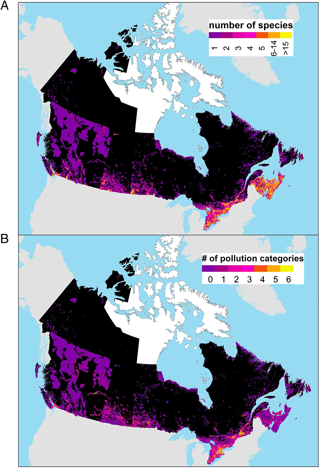
We observed a strong geographic bias in species at risk and pollution (Fig. 1). The richness of species at risk overlapped strongly with areas of greatest urbanization and landscape modification, such as southern Ontario, the Prairies, and the Lower Mainland of British Columbia (Fig. 1A). The number of categories of mapped pollution sources within grid squares occupied by one or more species at risk also tended to be higher in southern regions (Fig. 1B; see Supplementary Material 2 for overlap between occurrences of species at risk and each pollution category separately).
Fig. 1.
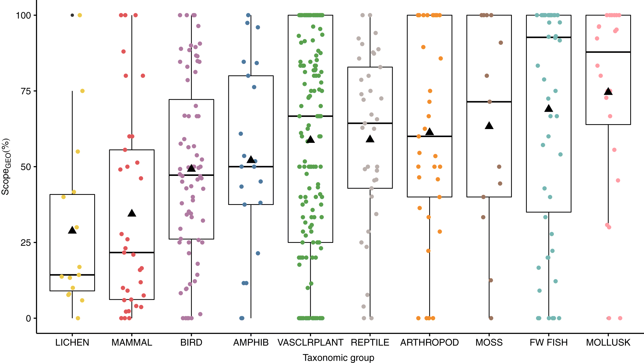
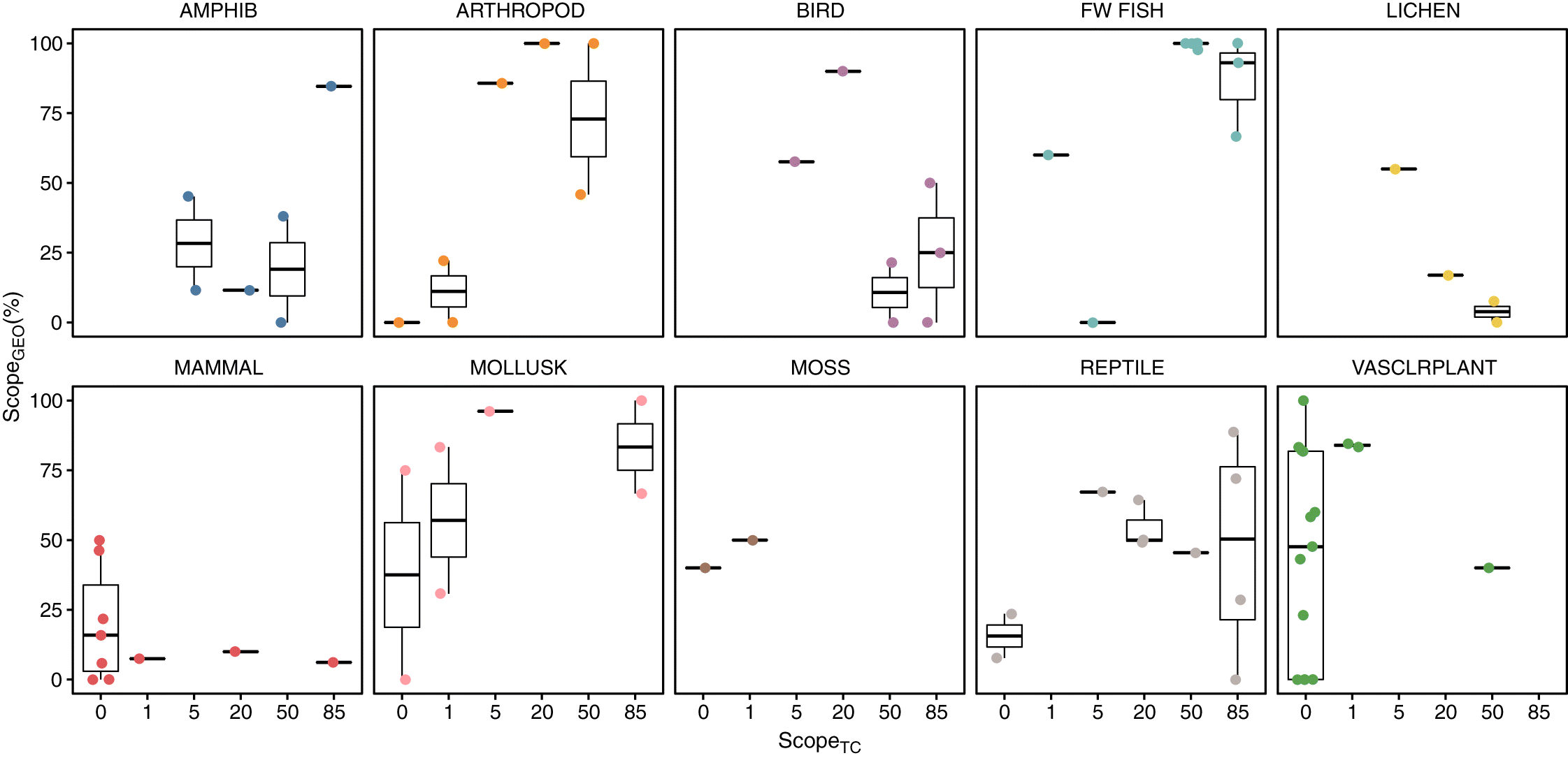
The proportion of mapped species occurrences that coincided with one or more categories of pollution (considering all pollution categories) ranged widely across the 488 species with mapping data (Fig. 2). On average, over half (57%) of a species’ range overlapped with at least one pollution source (all categories) and almost one-quarter (22%) of all species (n = 108) had at least one pollution source in all of the 100 km2 grid cells they are known to occupy (100% range overlap). Just over 12% of all species (n = 59) did not overlap with a single pollution source. Significant differences in scopeGEO existed between taxonomic groups; on average, fish and molluscs exhibited a significantly higher proportion of overlap compared with lichens and mammals, whereas vascular plants exhibited a significantly higher proportion of overlap compared with mammals (Fig. 2; Supplementary Material 3). Between taxonomic groups, differences were also present when considering each pollution category separately (Supplementary Material 3). For example, fish had significantly greater average overlap with Household Sewage and Urban Waste Water (category 9.1) than birds or mammals (respectively, mean percentage overlap = 50%, 30%, 20%). Mosses had significantly greater average overlap with Air-borne Pollutants (category 9.5) than birds, lichens, or mammals (respectively, mean percentage overlap = 49%, 20%, 8%, 16%; Supplementary Material 3).
Fig. 2.
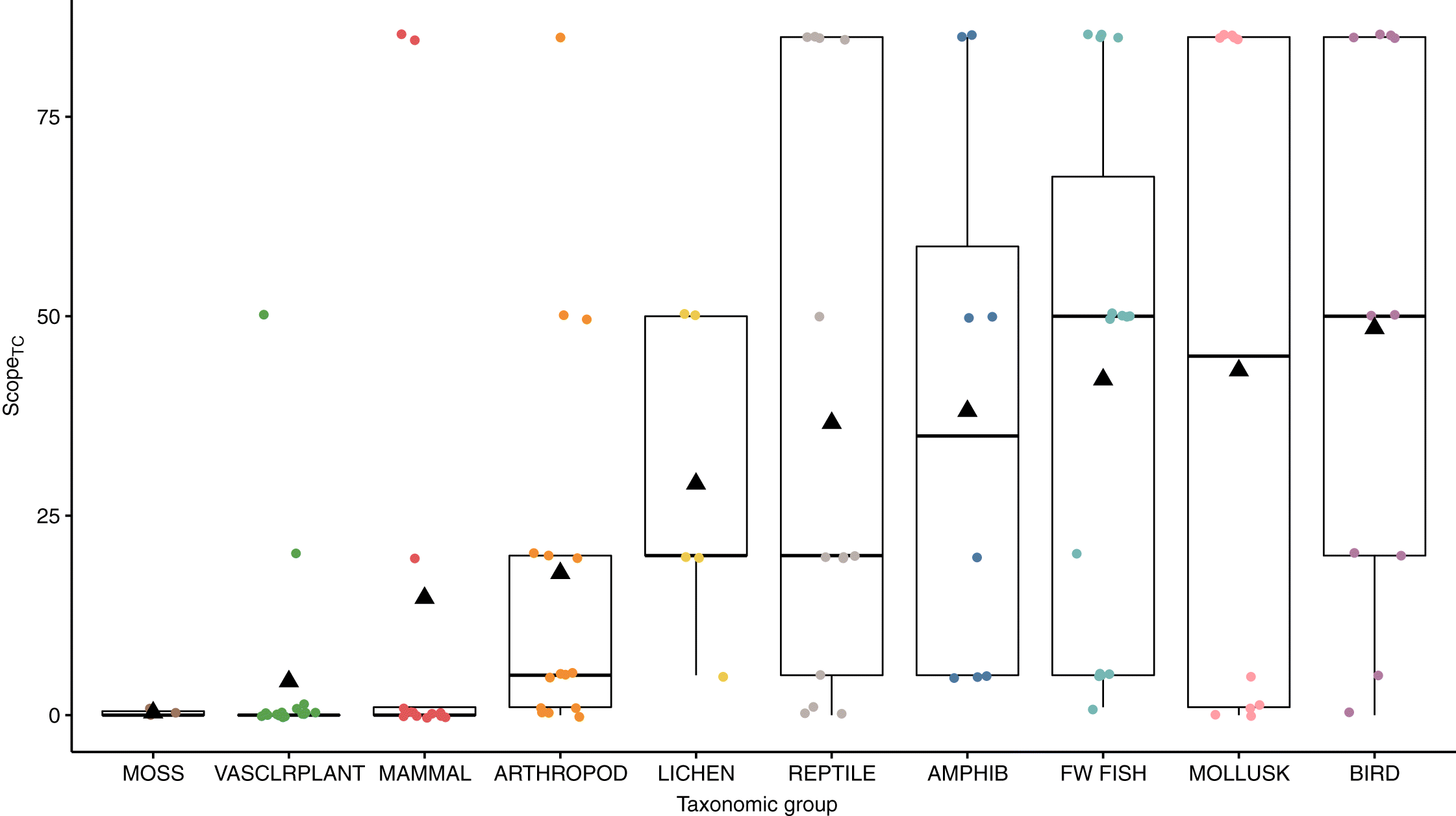
We also observed high inter-specific variation among scopeTC scores (Fig. 3). However, most species with Threats Calculators received either the highest scope (“pervasive”) or zero; fewer species received intermediate scores. Freshwater fish and birds had significantly higher scopeTC than vascular plants. Pairwise differences between taxonomic groups were otherwise not significant (Table S4b, Supplementary Material 4). There were also some significant differences when considering each pollution category separately (Supplementary Material 4). For example, fish and molluscs had significantly higher scope for Agricultural Effluents (category 9.3) than mammals and vascular plants.
Fig. 3.
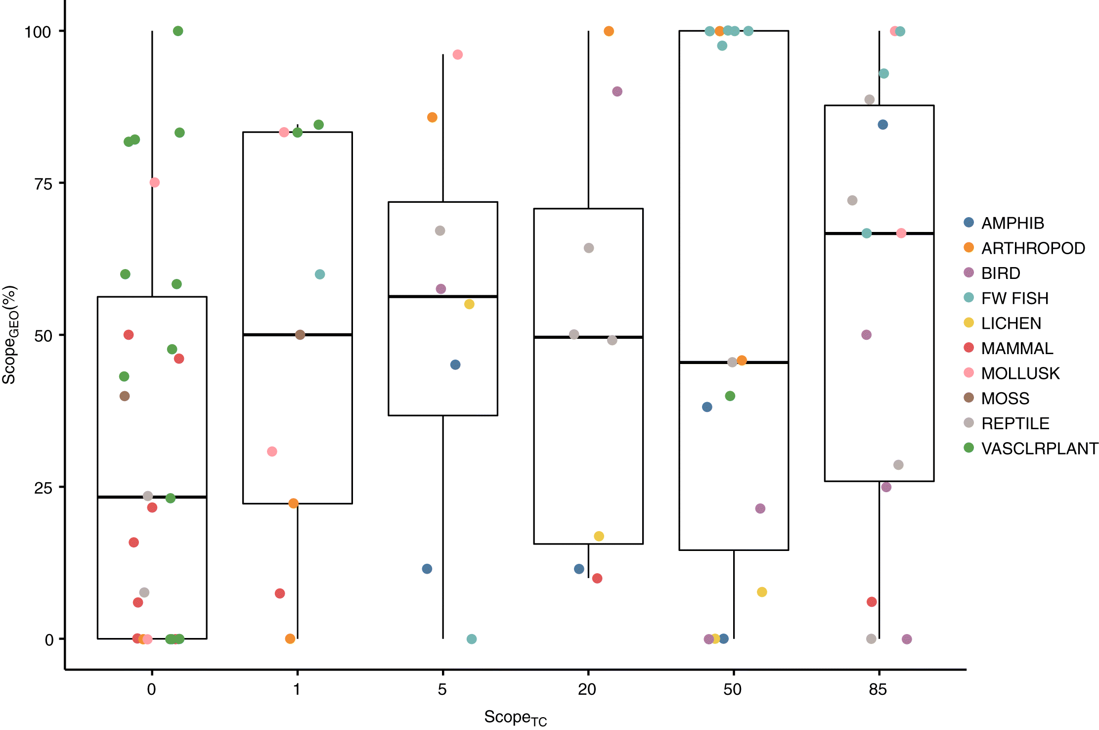
For the 80 species with both mapping data and Threats Calculators, the relationship between scopeGEO and scopeTC was weak. Although scopeTC was positively related to the proportion of geographic overlap with pollution sources, there was substantial unexplained variation (Fig. 4). A cumulative logit model for scopeTC based on scopeGEO was significantly better than an intercept-only model (p(χ2) = 0.029; ΔAIC = 2.79); however, the model explained only 1.77% of the residual deviance. The significant relationship is driven by the tendency for species with scopeTC pervasive to have higher proportion overlap, and species with scopeTC zero to have lower proportion overlap—there was little or no correspondence for the scope levels in between (Fig. 4; Supplementary Material 5).
Fig. 4.
ScopeGEO and scopeTC correspond strongly for some taxonomic groups, but poorly for others (Fig. 5). For example, mollusc species generally had a higher scopeTC with higher scopeGEO. The Yellow Lampmussel (Lampsilis cariosa) and Round Hickorynut (Obovaria subrotunda) both received a Threats Calculator scope of pollution of pervasive, corresponding to geographic overlap of 66.7% and 100%, respectively, whereas the Haida Gwaii snail with scopeTC of 0 correspondingly had a scopeGEO of 0%. However, some taxonomic groups, including molluscs, include species that scored 0 for scopeTC despite a large proportion of their known occurrences coinciding with one or more pollution sources. Incongruous scoring for scope was especially common in Threats Calculators for vascular plants and terrestrial mammals (Fig. 5).
Fig. 5.
Results comparing scopeTC and scopeGEO for each pollution category separately varied by pollution category. Species with a higher Threats Calculator scope for Household Sewage and Urban Waste Water (category 9.1) and Agricultural Effluents (category 9.3) also tended to have a higher proportion overlap, but there was a great deal of variation (Supplementary Material 5). Importantly, scopeGEO was not a significant predictor of scopeTC for any of the other pollution categories, and scopeTC was heavily zero-inflated (Supplementary Material 5).
Discussion
When considering all pollution categories together, we found little correspondence between the proportion of geographic overlap (scopeGEO) and assessed scope (scopeTC). Many species at risk that were assessed geographically as having high proportions of their known occurrences co-occurring with pollution sources received a score of zero or “negligible” for pollution in Threats Calculators. Mismatches of this type are concerning and suggest that the decision to score the scope of pollution as null or negligible may be made in the absence of supporting evidence. For example, the American hart’s-tongue fern (Asplenium scolopendrium var. americanum) occurs in 55 grid cells in southern Ontario, 45 of which also contain one or more pollution sources. Yet the Threats Calculator scores pollution scope as zero. The Lake Ontario population of the channel darter (Percina copelandi) occurs in only 10 grid cells, six of which co-occur with one or more point sources of pollution, but the Threats Calculator ranks the scope as negligible (<1% of the population affected). The gypsy cuckoo bee (Bombus bohemicus) and the spotted turtle (Clemmys guttata) have 86% and 67%, respectively, of their occupied grid cells co-occurring with at least one pollution source. However, the Threats Calculator for each of these species ranks the scope of pollution as “small” (1%–10% of the population). Other studies have suggested that exposure to pollution may be underestimated in conservation assessments and recovery planning. For example, an analysis of the impacts of oil development in Saskatchewan’s grasslands on species at risk concluded that the potential impacts of water pollution from oil or fracking were not mentioned in recovery documents, even though evidence supports that oil development has an impact on grassland birds and other species (Olive 2018).
There were also cases of mismatches in the opposite direction, whereby species with low geographic overlap with pollution sources nonetheless were scored a “large” or “pervasive” scope by experts participating in Threats Calculator panels. For example, many lichen species have received a scope of large for Air-Borne Pollutants, even though they rarely co-occur with point sources of this pollution category. Experts in these cases may have factored in the well-known ability of air pollutants to disperse over immense distances, and the documented accumulation of atmospheric contaminants in lichens, in assessing the scope of this pollution category (e.g., Carignan et al. 2002; Graney et al. 2017).
Our analysis shows that species at risk and pollution sources co-occur at a high rate in Canada. In general, the highest densities of pollution sources and species at risk are concentrated in the south, where the human population density is also highest. This observation corroborates a well-known pattern in Canada, in which species are disproportionately threatened in southern portions of the country, corresponding with regions of high human habitation (Coristine and Kerr 2011). There is no question that species at risk in Canada are threatened by habitat destruction, natural resource extraction, hunting and gathering, and disturbance via human recreation and work (McCune et al. 2013). Nonetheless, the scope of pollution as a threat is also high—especially for southern species—and should not be overlooked despite the dominant and sometimes more obvious presence of other threats. The taxonomic differences that we observed in proportion of geographic overlap between species’ ranges and pollution sources largely conforms with the distribution patterns of taxonomic groups. For all pollution categories combined, mammals and lichens have the lowest proportional overlap because they tend to have more northerly distributions, whereas freshwater fishes, molluscs, and vascular plants are dominated by species with southerly distributions.
We assume that if a species is present in a 10 km × 10 km grid cell that also contains one or more pollution sources, there is potential for exposure to the pollutant. In practice pollution effects will vary with the category of pollution, type of species, and proximity of the species to the source of pollution. For example, if a vascular plant species is present in the same grid cell as a municipal garbage dump, but is still several kilometres away, there may be a very low chance that the dump will threaten the plant species. In the case of other threat categories, the potential for a pollution source to threaten a species that co-occurs in the same grid cell is not easy to estimate. For example, nearly one-third of mapped vascular plant species at risk have 50% or more of their occurrences in grid cells that also include intensive agricultural land use. There are few studies considering the impact of herbicide or pesticide drift, or other agriculture-related pollution, on vascular plants growing nearby or at what distances such effects could manifest (but see Marrs et al. 1989; Boutin and Jobin 1998). Based on the definition of scope, it is reasonable to expect that those plants could be affected by agricultural effluents, yet only one vascular plant with a Threats Calculator has a scope >0 for agricultural pollution. In general, especially when little is known about contaminant concentrations, the distances they can move, or susceptibility of the species, it is prudent to assume that populations within a 10 km × 10 km grid cell that also contains a pollution source are more likely to be exposed to that pollution category than those in grid squares that do not contain a potential source of pollution. Therefore, species that co-occur with a pollution category should receive a non-zero value for the scope of that pollution category.
The scope of pollution as assessed by COSEWIC expert panels in Threats Calculators (scopeTC) was significantly lower for vascular plants than for freshwater fishes and birds. Taxonomic differences in scopeTC may reflect the expertise or conventions of the groups conducting assessments. COSEWIC relies heavily on the expertise of Species Specialist Sub-Committees (SSCs) that are responsible for particular taxonomic groups and whose members participate in completing Threats Calculators. Different SSCs may have slightly different tendencies in their scoring of pollution as a threat. For example, members of Threats Calculator groups for vascular plants may tend to record the scope of pollution as zero when the severity of pollution is deemed minimal or not a factor. We believe it is important to keep scope and severity separate, especially given the rapid evolution of new sources of pollution and changing scientific understanding of the effects of pollution on species. Data on geographic overlap provides a standardized and more rigorous method to quantify minimum scope. The species experts can then use these geographic data to inform more nuanced, species-specific discussions.
Our geographically explicit determination of overlap contributes to an evidence-based, systematic determination of minimum scope, which can then be modified based on evidence if and when evidence is available. Additional evidence could include substantiated information about: the area of pollutant influence, environmental persistence, and susceptibility of a particular species or taxonomic group. For example, excess energy such as light pollution has a pronounced effect on bird species’ migration routes, foraging times, and reproduction (Longcore and Rich 2004), yet the impacts to plants may be less direct (Bennie et al. 2015).
Pollution has been ranked below other threats, including habitat loss, overexploitation, and invasive species, in literature reviews of the dominant threats to species at risk (e.g., Venter et al. 2006; Prugh et al. 2010; McCune et al. 2013). A recent global analysis revealed that, even though the production and diversification of synthetic chemicals outpaces other agents of global change, mainstream ecological journals, meetings, and funding devote only a tiny effort (<2%) to the study of synthetic chemicals—which, unfortunately, has contributed to an ignorance among ecologists about how synthetic chemicals affect biodiversity and ecosystem function (Bernhardt et al. 2017). Our study, together with others, shows how the paucity of information about contaminants translates into pollution being underestimated as a threat to species at risk in Canada.
Acknowledgements
This project was made possible through funding from the Liber Ero Fellowship to all authors, an NSERC postdoctoral fellowship to JLM, and a Banting postdoctoral fellowship to DMO. We gratefully acknowledge NatureServe, the Nature Conservancy of Canada, and the Atlantic Canada Conservation Data Centre for sharing the species at risk occurrence data.
References
Agresti A. 2002. Categorical data analysis. Wiley, New York, New York.
Atlantic Canada CDC. 2016. Digital database of species locations for Newfoundland and Labrador. Atlantic Canada Conservation Data Centre, Sackville, New Brunswick.
Bennie J, Davies TW, Cruse D, Inger R, and Gaston KJ. 2015. Cascading effects of artificial light at night: resource-mediated control of herbivores in a grassland ecosystem. Philosophical Transactions of the Royal Society B, 370(1667): 20140131.
Bernhardt ES, Rosi EJ, and Gessner MO. 2017. Synthetic chemicals as agents of global change. Frontiers in Ecology and the Environment, 15: 84–90.
Boutin C, and Jobin B. 1998. Intensity of agricultural practices and effects on adjacent habitats. Ecological Applications, 8(2): 544–557.
Brook BW, Sodhi NS, and Bradshaw CJ. 2008. Synergies among extinction drivers under global change. Trends in Ecology & Evolution, 23(8): 453–460.
Carignan J, Simonetti A, and Gariépy C. 2002. Dispersal of atmospheric lead in northeastern North America as recorded by epiphytic lichens. Atmospheric Environment, 36: 3759–3766.
Choy ES, Kimpe LE, Mallory ML, Smol JP, and Blais JM. 2010. Contamination of an arctic terrestrial food web with marine-derived persistent organic pollutants transported by breeding seabirds. Environmental Pollution, 158(11): 3431–3438.
Coristine LE, and Kerr JT. 2011. Habitat loss, climate change, and emerging conservation challenges in Canada. Canadian Journal of Zoology, 89(5): 435–451.
Darling ES, and Côté IM. 2008. Quantifying the evidence for ecological synergies. Ecology Letters, 11(12): 1278–1286.
DMTI Spatial Inc. 2014. CanMap RouteLogistics user manual v2014.2.
DMTI Spatial Inc. 2015. CanMap ContentSuite Data Dictionary, 2015.3 release.
Donato DB, Nichols O, Possingham H, Moore M, Ricci PF, and Noller BN. 2007. A critical review of the effects of gold cyanide-bearing tailings solutions on wildlife. Environment International, 33: 974–984.
Dudgeon D, Arthington AH, Gessner MO, Kawabata ZI, Knowler DJ, Lévêque C, et al. 2006. Freshwater biodiversity: importance, threats, status and conservation challenges. Biological Reviews, 81: 163–182.
Government of Canada. 2016a. About COSEWIC [online]: Available from cosewic.gc.ca/eng/sct6/index_e.cfm.
Government of Canada. 2016b. Status reports [online]: Available from cosewic.gc.ca/eng/sct2/index_e.cfm.
Government of Canada. 2017a. Wastewater regulations overview [online]: Available from canada.ca/en/environment-climate-change/services/wastewater/regulations.html.
Government of Canada. 2017b. Groundwater contamination [online]: Available from ec.gc.ca/eau-water/default.asp?lang=En&n=6A7FB7.
Government of Canada. 2017c. About federal contaminated sites [online]: Available from canada.ca/en/environment-climate-change/services/federal-contaminated-sites.html.
Government of Canada. 2018. Canada’s National Pollutant Release Inventory: data highlights 2017 [online]: Available from canada.ca/en/environment-climate-change/services/national-pollutant-release-inventory/tools-resources-data/fact-sheet.html.
Graney JR, Landis MS, Puckett KJ, Studabaker WB, Edgerton ES, Legge AH, et al. 2017. Differential accumulation of PAHs, elements, and Pb isotopes by five lichen species from the Athabasca Oil Sands Region in Alberta, Canada. Chemosphere, 184: 700–710.
Haney JC, Geiger HJ, and Short JW. 2014. Bird mortality from the Deepwater Horizon oil spill. II. Carcass sampling and exposure probability in the coastal Gulf of Mexico. Marine Ecology Progress Series, 513: 239–252.
Hernández DL, Vallano DM, Zavaleta ES, Tzankova Z, Pasari JR, Weiss S, et al. 2016. Nitrogen pollution is linked to US listed species declines. BioScience, 66: 213–222.
Incardona JP, Carls MG, Holland L, Linbo TL, Baldwin DH, Myers MS, et al. 2015. Very low embryonic crude oil exposures cause lasting cardiac defects in salmon and herring. Scientific Reports, 5: 13499.
IUCN. 2019. Threats Classification Scheme (version 3.2) [online]: Available from iucnredlist.org/resources/threat-classification-scheme.
Joppa LN, O’Connor B, Visconti P, Smith C, Geldmann J, Hoffmann M, et al. 2016. Filling in biodiversity threat gaps. Science, 352: 416–418.
Kidd KA, Blanchfield PJ, Mills KH, Palace VP, Evans RE, Lazorchak JM, et al. 2007. Collapse of a fish population after exposure to a synthetic estrogen. Proceedings of the National Academy of Sciences of the USA, 104: 8897–8901.
Kidd KA, Paterson MJ, Rennie MD, Podemski CL, Findlay DL, Blanchfield PJ, et al. 2014. Direct and indirect responses of a freshwater food web to a potent synthetic oestrogen. Philosophical Transactions of the Royal Society B, 369: 20130578.
Liggio J, Li SM, Hayden K, Taha YM, Stroud C, Darlington A, et al. 2016. Oil sands operations as a large source of secondary organic aerosols. Nature, 534(7605): 91–94.
Longcore T, and Rich C. 2004. Ecological light pollution. Frontiers in Ecology and the Environment, 2: 191–198.
Marrs RH, Williams CT, Frost AJ, and Plant RA. 1989. Assessment of the effects of herbicide spray drift on a range of plant species of conservation interest. Environmental Pollution, 59(1): 71–86.
McCune JL, Harrower WL, Avery-Gomm S, Brogan JM, Csergo AM, Davidson LNK, et al. 2013. Threats to Canadian species at risk: an analysis of finalized recovery strategies. Biological Conservation, 166: 254–265.
Mee JA, Bernatchez L, Reist JD, Rogers SM, and Tayler EB. 2015. Identifying designatable units for intraspecific conservation prioritization: a hierarchical approach applied to the lake whitefish species complex (Coregonus spp.). Evolutionary Applications, 8: 423–441.
Muir DC, and Howard PH. 2006. Are there other persistent organic pollutants? A challenge for environmental chemists. Environmental Science & Technology, 40: 7157–7166.
National Energy Board. 2019. Incidents at NEB-regulated pipelines and facilities [online]: Available from apps2.neb-one.gc.ca/pipeline-incidents/.
NatureServe. 2015. NatureServe Central DataBases. NatureServe, Arlington, Virginia.
NatureServe. 2019a. NatureServe conservation status assessments: rank calculator version 3.193 [online]: Available from connect.natureserve.org/conservation-tools/conservation-rank-calculator.
NatureServe. 2019b. National and subnational conservation status definitions [online]: Available from explorer.natureserve.org/nsranks.htm.
Nilsen E, Smalling KL, Ahrens L, Gros M, Miglioranza KS, Picó Y, et al. 2019. Critical review: grand challenges in assessing the adverse effects of contaminants of emerging concern on aquatic food webs. Environmental Toxicology and Chemistry, 38: 46–60.
Novacek MJ, and Cleland EE. 2001. The current biodiversity extinction event: scenarios for mitigation and recovery. Proceedings of the National Academy of Sciences of the USA, 98(10): 5466–5470.
Olive A. 2018. Oil development in the grasslands: Saskatchewan’s Bakken formation and species at risk protection. Cogent Environmental Science, 4: 1443666.
Ontario Council of University Libraries. 2016. Scholars Geoportal users guide [online]: Available from guides.scholarsportal.info/geoportal.
Papadimitriou T, Katsiapi M, Vlachopoulos K, Christopoulos A, Laspidou C, Moustaka-Gouni M, et al. 2018. Cyanotoxins as the “common suspects” for the Dalmatian pelican (Pelecanus crispus) deaths in a Mediterranean reconstructed reservoir. Environmental Pollution, 234: 779–787.
Prugh LR, Sinclair ARE, Hodges KE, Jacob AL, and Wilcove DS. 2010. Reducing threats to species: threat reversibility and links to industry. Conservation Letters, 3: 267–276.
R Core Team. 2018. R: a language and environment for statistical computing. R Foundation for Statistical Computing, Vienna, Austria [online]: Available from R-project.org/.
Rao YR, Howell T, Watson SB, and Abernethy S. 2014. On hypoxia and fish kills along the north shore of Lake Erie. Journal of Great Lakes Research, 40: 187–191.
Salafsky N, Salzer D, Stattersfield AJ, Hilton-Taylor C, Nuegarten R, Butchart SHM, et al. 2008. A standard lexicon for biodiversity conservation: unified classifications of threats and actions. Conservation Biology, 22: 897–911.
Sasaki K, Lesbarrères D, Beaulieu CT, Watson G, and Litzgus J. 2016. Effects of a mining-altered environment on individual fitness of amphibians and reptiles. Ecosphere, 7: e01360.
United Nations Environment Programme (UNEP). 2019. Global Chemicals Outlook II: from legacies to innovative solutions [online]: Available from unenvironment.org/resources/report/global-chemicals-outlook-ii-legacies-innovative-solutions.
Venter O, Brodeur NN, Nemiroff L, Belland B, Dolinsek IJ, and Grant JWA. 2006. Threats to endangered species in Canada. BioScience, 56: 903–910.
Supplementary material
Supplementary Material 1
- Download
- 153.13 KB
Supplementary Material 2
- Download
- 1.14 MB
Supplementary Material 3
- Download
- 1.02 MB
Supplementary Material 4
- Download
- 799.61 KB
Supplementary Material 5
- Download
- 690.27 KB
Information & Authors
Information
Published In
FACETS
Volume 4 • Number 1 • June 2019
Pages: 598 - 614
Editor: Stephen B. Heard
History
Received: 28 May 2019
Accepted: 24 August 2019
Version of record online: 27 November 2019
Copyright
© 2019 McCune et al. This work is licensed under a Creative Commons Attribution 4.0 International License (CC BY 4.0), which permits unrestricted use, distribution, and reproduction in any medium, provided the original author(s) and source are credited.
Data Availability Statement
All relevant data are within the paper and in the Supplementary Material.
Key Words
Sections
Subjects
Plain Language Summary
Pollution might be a bigger threat to endangered species in Canada than we think
Authors
Author Contributions
All conceived and designed the study.
All performed the experiments/collected the data.
JLM, CMD, and RS analyzed and interpreted the data.
All drafted or revised the manuscript.
Competing Interests
The authors have declared that no competing interests exist.
Metrics & Citations
Metrics
Other Metrics
Citations
Cite As
Jenny L. McCune, Sheila R. Colla, Laura E. Coristine, Christina M. Davy, D.T. Tyler Flockhart, Richard Schuster, and Diane M. Orihel. 2019. Are we accurately estimating the potential role of pollution in the decline of species at risk in Canada?. FACETS.
4(1): 598-614. https://doi.org/10.1139/facets-2019-0025
Export Citations
If you have the appropriate software installed, you can download article citation data to the citation manager of your choice. Simply select your manager software from the list below and click Download.
Cited by
1. Spatial and temporal patterns in the threats to at-risk freshwater fish species in Canada
2. Toward a wild pollinator strategy for Canada: expert-recommended solutions and policy levers
3. CAN-SAR: A database of Canadian species at risk information
4. Effects of methylmercury and food stress on migratory activity in song sparrows, Melospiza melodia
5. Resilience of larval wood frogs (Rana sylvatica) to hydrocarbons and other compounds released from naturally weathered diluted bitumen in a boreal lake
6. Canada’s human footprint reveals large intact areas juxtaposed against areas under immense anthropogenic pressure
7. Early warning indicators of population collapse in a seasonal environment
8. Key information needs to move from knowledge to action for biodiversity conservation in Canada
9. The biodiversity crisis in Canada: failures and challenges of federal and sub-national strategic and legal frameworks