Fluctuating water levels influence access to critical habitats for threatened Cowichan Lake lamprey
Abstract
Cowichan Lake lamprey (Entosphenus macrostomus) is a threatened species resident to Mesachie Lake, Cowichan Lake, and adjoining Bear Lake and their major tributaries in British Columbia. Decreases in trapping success have created concerns that the population is declining. Some potential threats include water use, climate change, and management actions. Owing to the absence of long-term data on population trends, little information is available to estimate habitat quality and factors that influence it. We sought to fill this gap by examining associations between habitat area and variables representing suspected key drivers of habitat availability. Critical habitat areas were imaged using an unmanned aerial vehicle over a period of three years at three sites at Cowichan Lake and a subsequent habitat area was classified. Meteorological and anthropogenic controls on habitat area were investigated through automatic relevance detection regression models. The major driver of habitat area during the critical spawning period was water level during the storage season, which also depends on the meteorological variables and anthropogenic control. It is recommended that regulation of the weir should aim to ensure that the water level remains above the 1 m mark, which roughly equates to the 67% coverage of water on the habitat area used for spawning.
1. Introduction
Identifying, characterizing, and tracking threats to critical habitat of endangered species is an active and important conservation need (Camaclung et al. 2015; Martin et al. 2017). Critical habitat is the minimum set of conditions and resources required for population persistence over time; however, methods and data required to delineate critical habitats differ significantly for different species. Globally, species using marine and freshwater habitats account for over 13 000 of International Union for Conservation of Nature Red List threatened species, and their protections can be impeded by lack of knowledge of basic ecology regarding their habitat requirements and related threats (Arthington 1998; Arthington and Pusey 2003; Arthington et al. 2016). To categorize threats and prioritize conservation and habitat protections, high-resolution mapping and spatial delineation of habitat boundaries is often needed. However, to better understand critical habitat requirements and threats, knowing the temporal dynamics of space utilization is also required; this often requires long-term observation of key variables and interactions, requirements out of sync with management timescales (Martin et al. 2017). Further, anthropogenic pressures on habitat that vary seasonally or periodically complicate static assessments of critical habitat. Therefore, the development of rapid mapping and data synthesis methods in support of critical habitat delineation is an important research need.
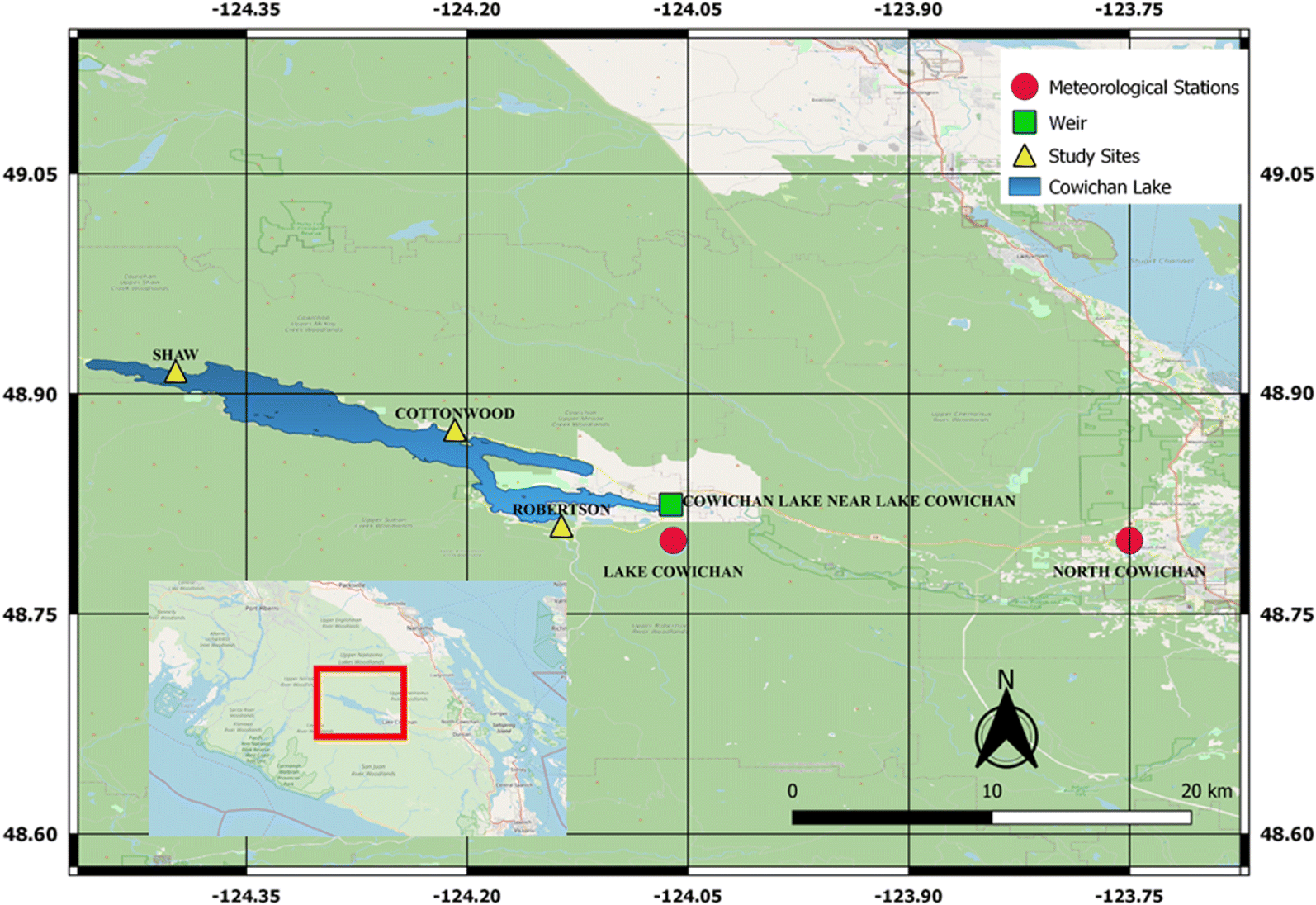
Cowichan Lake lamprey (Entosphenus macrostomus) is a freshwater parasitic fish species endemic to the Cowichan Valley watershed on Vancouver Island, British Columbia (DFO 2007; MacConnachie and Wade 2016). It was recognized as a distinct species in 1982 (Beamish 1982) and in 2003, was listed as Threatened under Canada’s Species at Risk Act (SARA). The listing is based on its restricted distribution and inherent vulnerability to localized threats (Wade et al. 2018a), including habitat alteration such as droughts and water management, sediment mobilized following upslope logging, and shoreline development (DFO 2016). Critical habitat for Cowichan Lake lamprey has been recommended as Cowichan and Mesachie Lakes in their entirety, the adjoining waterways (including the contiguous Bear Lake) and 100 m upstream of tributaries into the lakes (MacConnachie and Wade 2016) (Fig. 1). This critical habitat recommendation was made based on the habitat requirements and distribution of all life stages. Critical habitat has been proposed (MacConnachie and Wade 2016) and is waiting for formal legal approval by the issuance of a regulatory order under SARA.
Fig. 1.
Since its listing in 2003, there have been sporadic efforts to determine the basic biology and environmental requirements of the species. Adults in spawning condition have been captured from the beginning of May to the end of August, with peak spawning in June (Beamish and Wade 2008). Mature lampreys have been captured in three locations, the mouth of an unnamed tributary to Mesachie Lake (Beamish 1982; Beamish and Wade 2008), the mouth of Robertson River in Bear Lake (Beamish 1982; Wade et al. 2018a), and the confluence of Cottonwood Creek and Cowichan Lake (Wade et al. 2018a). Nest building and spawning was observed for the first time in 2017 at the mouth of Robertson River (Wade et al. 2018a). It is assumed that if spawning is occurring at the confluences of tributaries and lakes that early rearing of ammocoetes also occurs in these locations. The duration of the ammocoetes stage in the life cycle of Cowichan Lake lamprey is unknown, but in similar species range from 30 to 84 months (Wade 2019). Excluding landlocked populations of anadromous lamprey, eight species of freshwater parasitic lamprey have been identified. The basic biology of two species, Chestnut lamprey (Ichthyomyzon castaneus) and Silver lamprey (Ichthyomyzon unicuspis) has been studied (see Wade 2019 for details).
Cowichan Lake lamprey and Miller Lake lamprey (Eremosaprinus minimus) are the only two species of freshwater parasitic lamprey known to spawn in the nearshore area of lakes (most species spawn in tributaries) (Wade 2019). Although few studies of have been conducted on the distribution of ammocoetes in Cowichan and Mesachie Lakes, ammocoetes can be found near the outflow if creeks and rivers emptying into these lakes and where suitable rearing habitat exists (MacConnachie and Wade 2016). Miller Lake lamprey have also been observed spawning in rivers (Lorion et al. 2000), while to date Cowichan Lake lamprey have not. As the tributaries to Cowichan and Mesachie Lakes routinely dewater during the summer, it is unlikely that these areas would be reliable spawning locations. Cowichan Lake lamprey have been observed spawning in loose sand with small pebbles and rocks on three different occasions in water 42, 58, and 65 cm deep (Wade et al. 2018a). Temperature was measured for a 9 d period during which the average daily temperature was 18.2 °C (Wade 2017). Experiments were conducted in 2018 to determine the spawning period and extent of tributary use for spawning; however, efforts were cut short due to drought conditions (Wade et al. 2018b).
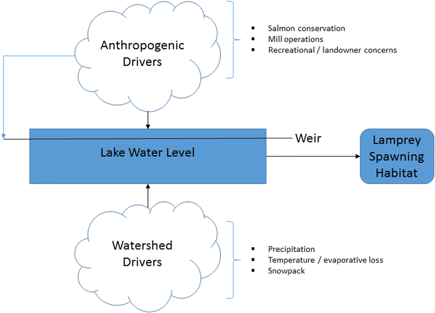
MacConnachie and Wade (2016) recommended Cowichan and Mesachie Lakes in their entirety, the adjoining waterways, and 100 m upstream of tributaries into the lakes as critical habitat. Once authorized by the Federal Fisheries Minister, this habitat will be protected under SARA. The outflow of Cowichan Lake, and by consequence the lake level, is regulated through a weir which has supplied water since 1957 via the Cowichan River to meet the socio-economic and ecological needs of the watershed (Stephen and Wade 2018). As water level directly relates to available spawning habitat in nearshore outflow areas, and is the outcome of both anthropogenic (i.e., regulation via the weir) and natural drivers (such as temperature and precipitation), we hope to better understand how habitat area relates to these drivers.
Figure 2 demonstrates our hypothesized conceptual diagram of the social–ecological–hydrometeorological drivers that affect the spawning habitats of the Cowichan Lake lamprey. The weir-controlled lake water level affects lamprey spawning habitat during critical life phases. Lamprey in spawning condition have been captured as early as 3 May and as late as 18 August (Beamish and Wade 2008). These dates can provide guidance as to a spawning period for the species but should be used cautiously as few studies have been conducted to refine this timing. The weir is typically regulated from March to October (Weir Operation Guidelines 2016). Dates and flow vary depending on environmental conditions in-season. The lake water level has two major drivers: watershed drivers that consist of precipitation, temperature and evaporation loss, and snowpack melting, and anthropogenic drivers that consist of weir operation and water withdrawal for downstream use including salmon conservation, water requirements for a timber mill, and recreational and landowner requirements (Department of Fisheries and Oceans Canada 2016). In this study, we aim to quantify the relative importance of selected drivers through investigation of relationships between meteorological variables, anthropogenic controls on water level, and lamprey habitat area at selected sites.
Fig. 2.
Therefore, the objectives of this study were to:
1.
Characterize seasonal fluctuation of lamprey spawning habitat area while considering ecological, hydro-meteorological, and anthropogenic controls.
2.
Build a conceptual framework of different drivers affecting the lamprey spawning habitat.
3.
Provide viable recommendations to conserve lamprey habitat areas on Cowichan Lake.
2. Methods
Several sources of data were combined into a two-step analytical process to characterize spawning habitat of Cowichan Lake lamprey and its relationship to lake level. First, aerial surveys via unmanned aerial vehicle (UAV) were conducted along with field data collection to obtain spatially detailed maps of known or suspected spawning habitat sites. These sites were surveyed 11 times during the spring summer and fall of 2017 and 2018. Second, UAV-derived habitat maps were linked to hydrological parameters with data available over a long time series. Systematic relationships between spatial and temporal drivers allowed for a retrospective analysis of habitat change to gauge the relative threats posed by recent changes in water demand and availability of water resources from winter snowpack.
2.1. Study sites
Cowichan Lake is one of the largest bodies of water on Vancouver Island, British Columbia; it encompasses an area of 6204 ha and reaches a maximum depth of 152 m and mean depth of 50 m (Cowichan Watershed Board in MacConnachie and Wade 2016). Cowichan Lake is an oligotrophic, monomictic lake that does not freeze in the winter and only stratifies in the summer (Vancouver Lamprey Recovery Team 2007; BC Lake Stewardship Society 2014). It is bordered by steep mountains and a rocky shoreline (BC Lake Stewardship Society 2014). Situated at an elevation of approximately 164 m, the lake empties into Cowichan River through a controlled weir located in the Town of Lake Cowichan (MacConnachie and Wade 2016).
The watershed is home to a variety of recreational and economic water resource users. There are approximately 6000 residents in Cowichan Lake area with several thousand summer visitors (MacConnachie and Wade 2016). Cowichan region is an agricultural area with a high potential for increased agricultural development with 80% of the arable land in the watershed requiring irrigation (Cowichan Watershed Board). The area has a long history of logging and continues today in the watershed. Another user in the watershed is a paper mill located in Crofton, British Columbia. They extract water from the Cowichan River to maintain operations.
Cowichan Lake currently functions as a water source for the Town of Lake Cowichan and a reservoir supporting the ecological and anthropogenic functions of the watershed (MacConnachie and Wade 2016). The weir is operated to serve two main goals: to maintain a discharge rate in Cowichan River above 7 m3/s and to maintain sufficient water in Cowichan Lake as long as possible (MacConnachie and Wade 2016). It has been typical that in late summer it is not possible to satisfy both objectives, and operational judgement is made based on lake level, discharge rate in Cowichan River, salmon priorities, and rainfall predictions (Cowichan Watershed Board). In recent years, water storage shortages have occurred earlier in the year.
Three study sites were selected as spawning and early rearing habitat for Cowichan Lake lamprey. This species has been shown to spawn in the alluvial fan area (Wade et al. 2018a); therefore, the survey sites were in these areas where rivers or creeks empty into lakes. The primary study site is Robertson River (Fig. 1). This river empties into Bear Lake, but as it is contiguous with Cowichan Lake (accessible through a large, deep channel) for the purposes of this study is considered emptying into Cowichan Lake. Cottonwood Creek and Shaw Creek are the two other study sites. They are located on the northern side of Cowichan Lake (Fig. 1). Like Robertson River, Cottonwood Creek empties into Cowichan Lake creating a visible alluvial fan with rapid and steep drop off. Shaw Creek does not have as discernable alluvial fan due to deep pools near the convergence with the Lake.
2.2. Phase 1—spatial data acquisition and habitat mapping
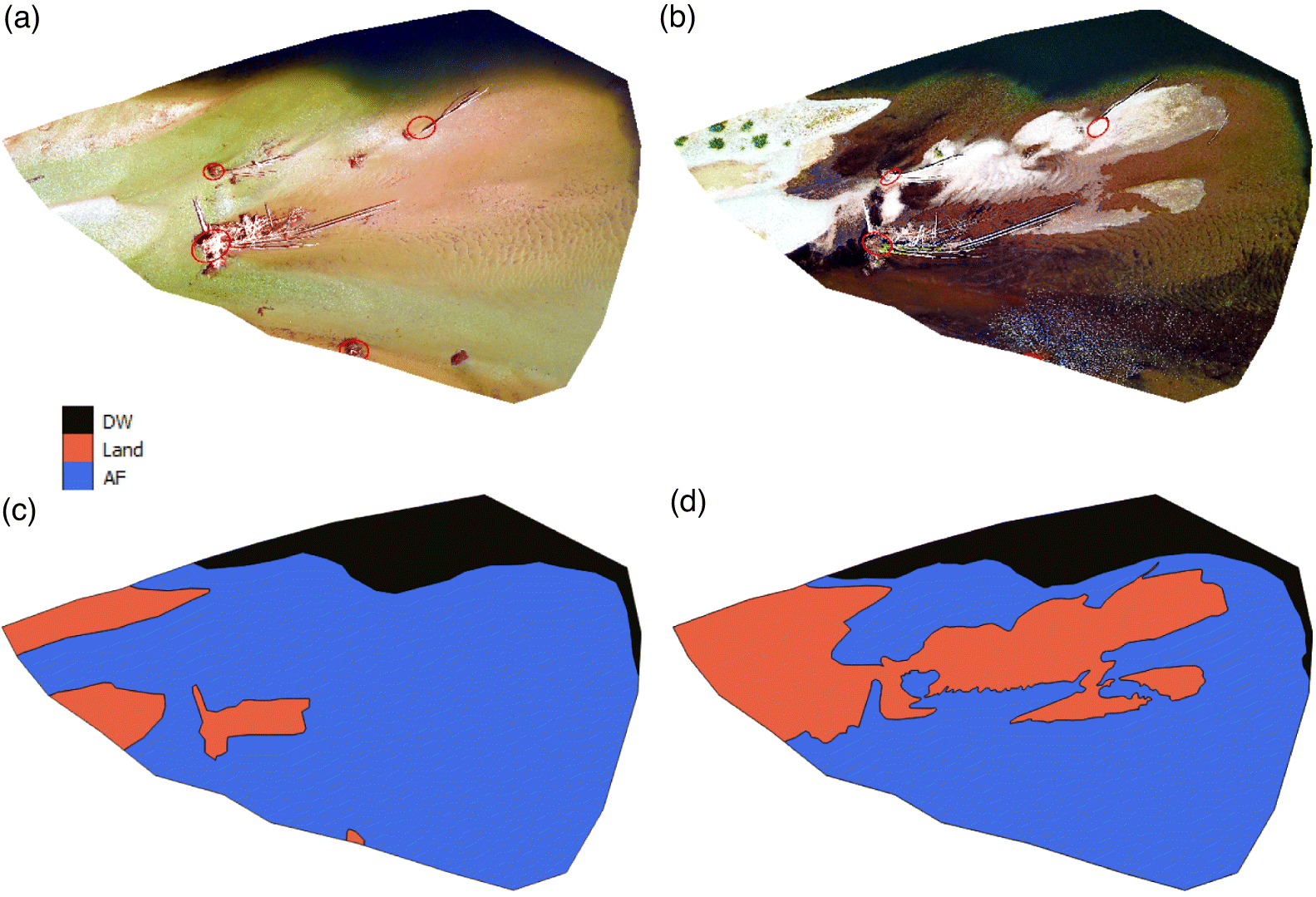
Aerial images were obtained from flight campaigns in 2017 and 2018 at the mouths of Robertson River, Shaw Creek, and Cottonwood Creek (Fig. 1). All images were taken at a maximum altitude of 119 m in an orthogonal position with a DJI Mavic Pro drone. Landmarks were identified and georeferenced using a handheld GPS (Garmin GPSmap 60Cx, Garmin Ltd., Olathe, Kansas, United States). Visual inspection through Google Earth was used when landmark data were unavailable. The georeferenced images have a resolution of 2 m. Georeferenced images were then mapped into three polygon features classes using ArcGIS software (ArcGIS software; Esri, Redlands, California, United States) to identify dark water (DW), alluvial fan (AF), and land (Land). Figure 3 shows examples of the classification results for the Robertson River site during June and September 2018. Deep water is defined as the lake area around the alluvial fan. Alluvial fan is defined as the depositional area at the confluence of the tributary and lake, the key habitat class for spawning and early rearing for Cowichan Lake lamprey. Land was defined as the area within the spatial boundaries which is not wetted.
Fig. 3.
Because images were acquired in different positions throughout the various field campaigns, the area common to all images used for analysis had to be identified and extracted. As the amount of overlap at Cottonwood and Shaw creeks was too small to establish a relationship with hydro or meteorological variables, the images from these sites are described qualitatively. The study focuses on samples taken in the spring, summer, and early fall in each of the three locations in 2018 (images taken during 2017 could not be used due to image quality problems). Furthermore, field surveys and spawning traps (see Wade et al. 2018a, 2018b for details) were placed in the alluvial fan areas of major tributaries to Cowichan Lake in 2017 to attempt to capture lamprey in spawning condition and observe spawning and nest building. A total of 31 lamprey were captured from three locations. Nest building was only observed in one location, at the confluence of Robertson River and Cowichan Lake, in the alluvial fan. Most fish (29/31) were captured in the traps installed at the Robertson River location. In 2018, these efforts were repeated in the most successful location, the mouth of Robertson River, and the study was expanded to determine the spawning window and if lamprey were spawning in the river.
2.3. Phase 2—retrospective habitat change analysis
Meteorological data from two Environment Canada stations near our study sites were obtained to provide historical weather data for the retrospective analysis. The Lake Cowichan station (48.8°, −124.06°, 171 m mean sea level (MSL)) and North Cowichan station (48.8°, −123.75°, 45 mg MSL) observations for the period 1980–2018 were extracted from the Environment Canada climate data Application Programming Interface through the R package rclimateca (github.com/paleolimbot/rclimateca). Lake water level data were obtained for the Cowichan Lake gauge from Environment Canada website (wateroffice.ec.gc.ca/mainmenu/historical_data_index_e.html). These data were used to build a regression model to predict habitat area at the Robertson study site during the survey year (2018). To capture the influence of antecedent conditions on water level, we used the 7-d average maximum, minimum, and mean temperatures; the total rainfall from Lake Cowichan weather station; and the 7-d total rainfall from North Cowichan weather station as independent variables to predict total habitat area at our primary study site (Robertson River). The correlation matrix of these variables and our dependent variable, AF area, are presented in Table S1.
These variables were normalized and then applied to an automatic relevance detection (ARD) regression framework (Tipping 2001). Compared to traditional ordinary least-square regression, this method can effectively handle multi-collinearity (Farrar and Glauber 1967) using regularization in a Bayesian framework (MacKay 1992). This will ensure the model gives suitable weights to the independent uncorrelated variables rather than similar weights for similar correlated variables. Given the inherent multicollinearity in our meteorological variables, this was an important modelling requirement.
The generative linear model of the ARD regression between the independent variables X and dependent variable Y is given by;where the random white noise ε ∼2 N (0, α) and the regularization over w is given by P(w|λ = N(0, λI) with the precision parameter λ = {λ1,…,λp} where p is the number of independent variables in vector X. The model parameters are estimated by minimizing;
(1)
(2)
Note, if the precision (λp) of any feature (p) is high, then its weight (wp) is likely to be close to zero. The assumption of elliptical Gaussian distribution regardless of weights leads to sparser w, which can be a measure of the relevance of the associated variable.
This model was used to compute the equivalent alluvial fan area for the entire lake height and meteorological data set (1982–2018). The earliest of entire coverage of data is available since 1982; therefore, we restrict our retrospective study period between 1982 and 2018. A key limitation of this method is that it assumes that the geomorphology of the site would remain the same every year. Since this is unlikely to be true, we consider our results illustrative of general conditions in alluvial fan areas around Cowichan Lake over time rather than the actual size of the AF at the study site.
Further, we tried to understand the governing factors for lake water level using the same regression framework. To properly understand the natural drivers, the variables were segregated into different “seasons” based on the regulation schedule at the weir. During the “free-flow” season (October–March), the weir floodgates remain open and water flows freely over the weir. During the “storage season” (April–June), the floodgates remain closed, and the water is stored up to the crest of the weir. During “regulation season” (July–September), the water is occasionally released following a specified regulation protocol which aims to maintain discharge in the river through the low water season at the end of August and early fall. These operations have a profound impact on the water level of the lake that cannot be captured through considerations of the natural drivers alone. Furthermore, animals in spawning condition have been observed from the beginning of May until the end of August, which in turn indicates the crucial impact of storage season and regulation season on the spawning of lamprey. We considered minimum seasonal water level as our target variable of interest as that can be critical to the water coverage on the alluvial fan area. We used seasonally averaged mean, maximum, and minimum temperatures and mean rainfall from Lake Cowichan station and seasonal mean rainfall from North Cowichan station as independent variables. Furthermore, to consider the antecedent conditions into our model, we used the water level from the previous season as another independent variable. While the model itself doesn’t consider anthropogenic activities, the segregation of season and consideration of water level from the previous season can act as a proxy for how human intervention is impacting spawning and early rearing habitat area for Cowichan Lake lamprey. The output of the models will provide guidance for water managers to ensure sufficient coverage of spawning habitat for Cowichan Lake lamprey.
3. Results
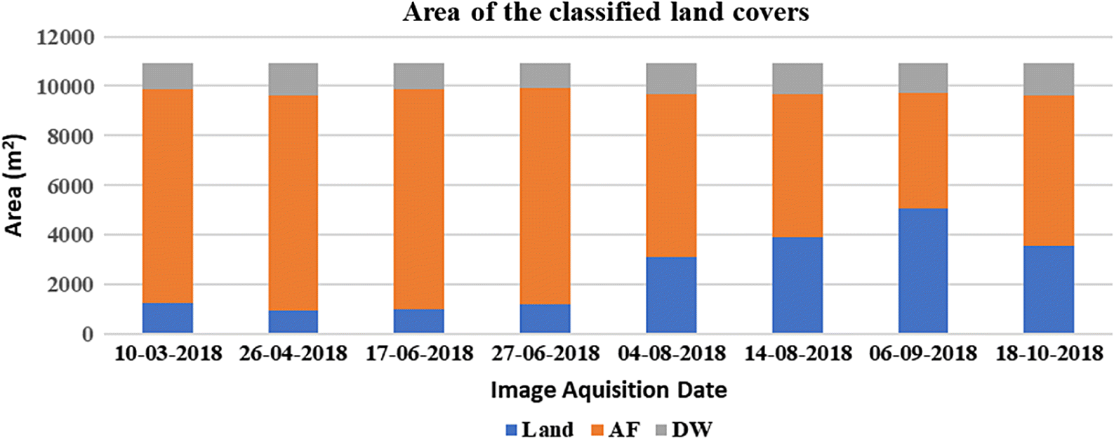
The total common study area identified via spatial overlap of georeferenced UAV images was measured as 10 948 m2. The landcover class areas at the Robertson River study site in 2018 are presented in Fig. 4. As expected in an area with little summer rainfall, the amount of alluvial fan area covered in water decreased throughout the summer with a resulting increase in dry land area. The drop in the alluvial fan area coincides with the period of active management of water level via the weir.
Fig. 4.
The correlation coefficient of the ARD multiple-linear regression is 0.95 with mean absolute relative error (MARE) of 5%. Coefficients and associated precisions of different variables are provided in Table S2. Lower values for precision estimates indicate how far the variable is from zero and vice versa. The coefficient values show that the lake water level as measured at the weir is the most relevant variable in the estimation of the extent of water coverage at the alluvial fan, followed by the precipitation at the North Cowichan weather station.
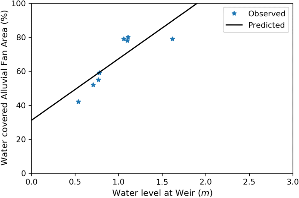
We excluded all variables except water level to see how much predictive power there was using this alone as a proxy for alluvial fan water coverage. Results of this model (Table S2) show that the correlation co-efficient between predicted and observed alluvial fan coverage is 0.84 with MARE of 10%. The relationship between the observed and predicted alluvial fan area from all the images at the Robertson River study site in 2018 for full and water-level only models is depicted in Fig. 5. Relating this back to water level at the weir, the percentage of water covered alluvial fan area in the total area of interest is compared against the water level in Fig. 6. We see that as water level varies from 0.5 to 1 m to 1.5 m, the percentage of the study site alluvial fan covered by water shifts from 50% to 67% and 85%, respectively.
Fig. 5.
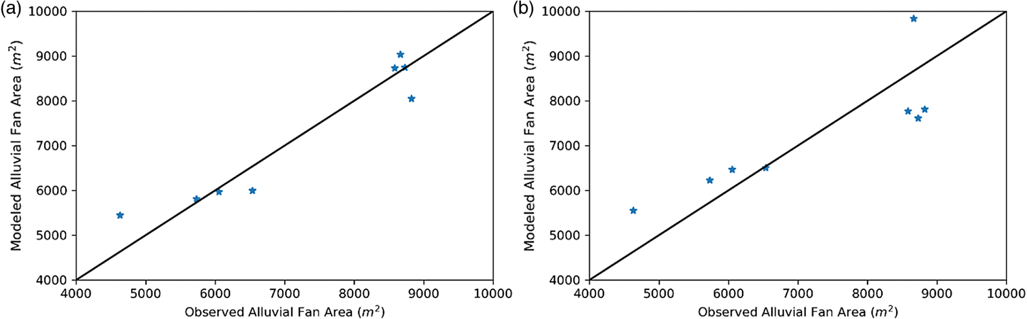
Fig. 6.
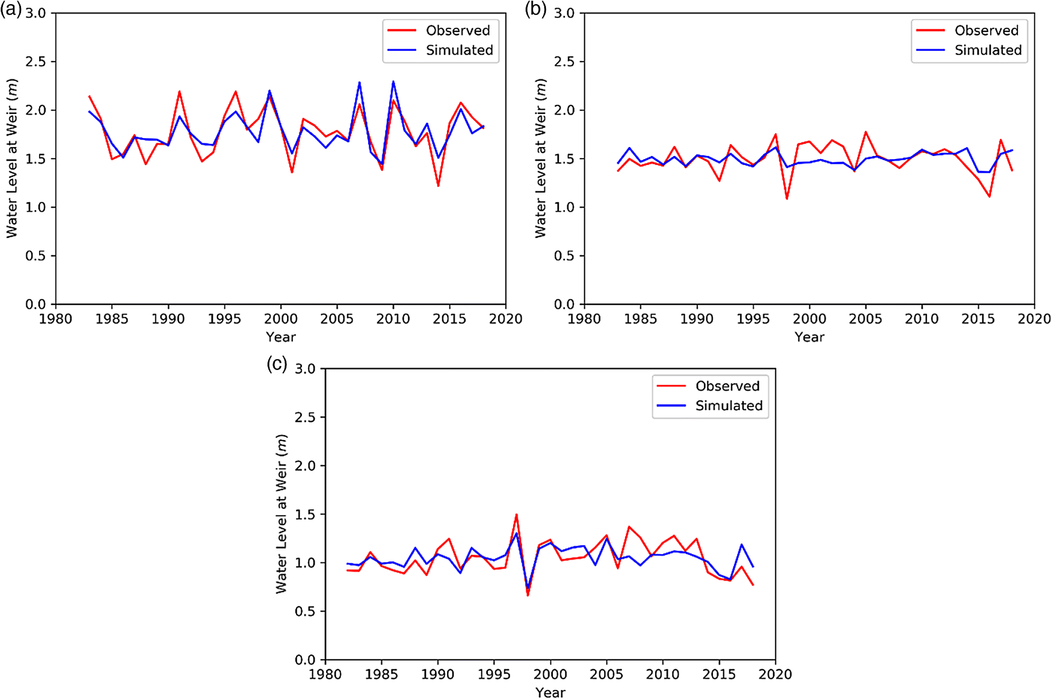
Because it is clear from the regression analysis above that water level at the weir plays a vital role in controlling the water coverage in the AF area, we tried to investigate the drivers that are important in controlling the minimum seasonal water level using ARD regression. Table S3 presents the coefficient values and associated precisions, and corresponding model results for different seasons and different variables. During free-flow season, the precipitation at the Lake Cowichan weather station influences the water level the most, with a model correlation estimate of 0.63 and MARE of 0.09. During the storage season, precipitation at both the North Cowichan and Lake Cowichan weather stations, along with the mean air temperature at Lake Cowichan plays important roles in predicting minimum water level at the AF area of Robertson River. During the regulation season, the water level in the storage season was the most explanatory factor. For the model during the storage season, the correlation was 0.5 with 7% MARE, while during the regulation season the correlation was 0.69 with MARE of 9%. Figure 7 compares the observed and predicted minimum seasonal water level during different seasons. For the regulated season, it is apparent that while the modelled water level is a good approximation of observed values for the overall time series, in recent years a gap has emerged suggesting perhaps other factors are becoming more important in determining lake water level.
Fig. 7.
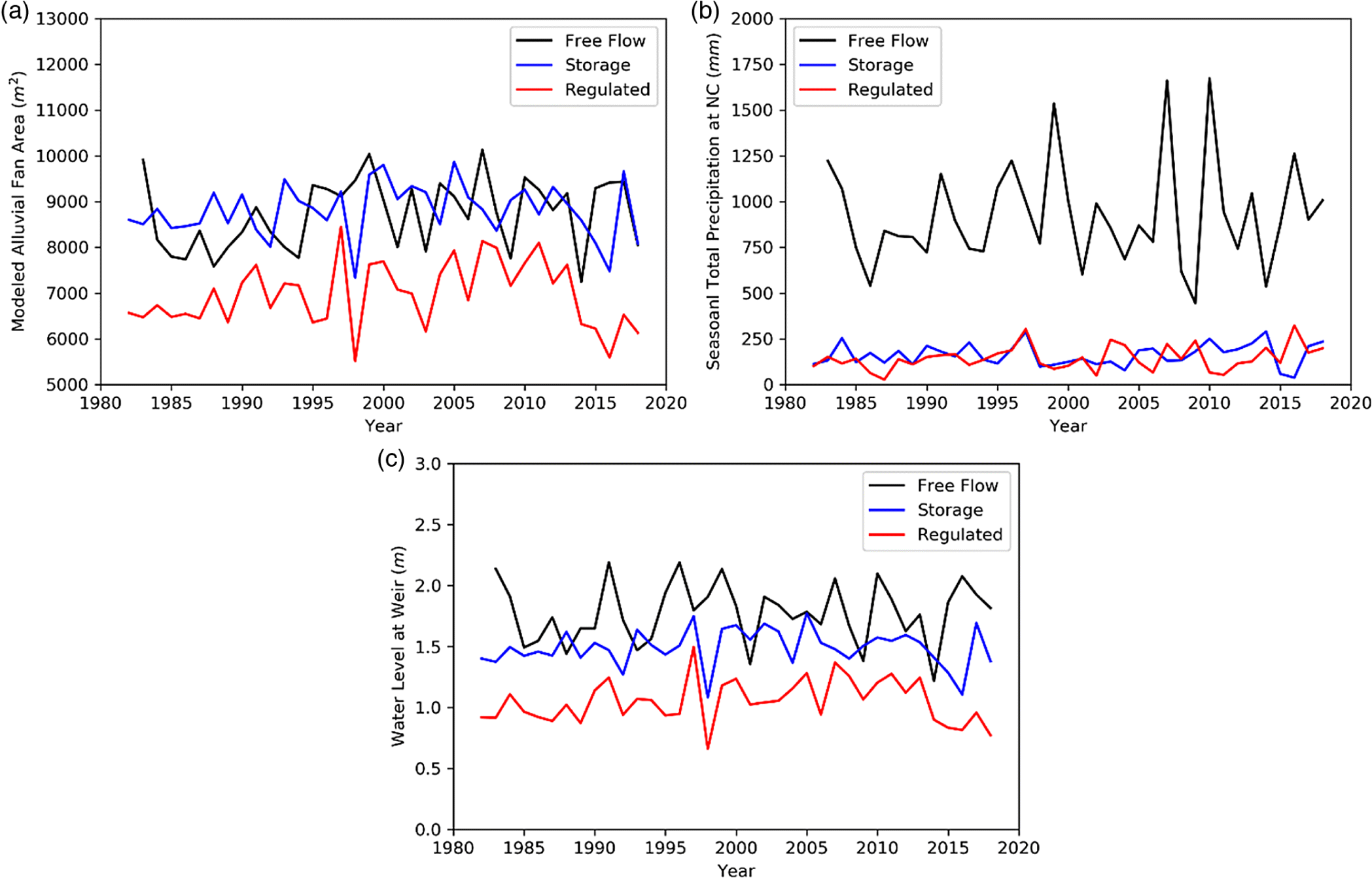
Back-casting of the AF area was done for the period 1982–2018 using the fitted model and covariates for lake level (Fig. 8). This output enabled us to closely analyze the seasonal and annual pattern of the habitat area and how it is related to the rainfall over the region. Interestingly, April 2017 was the historical maximum AF area. Furthermore, July and August 2018 fall (6494 and 5844 m2, respectively) well below the historical minimum level (6869 and 5869 m2, respectively). This suggests that when all other factors are held constant, 2018 was an exceptionally dry year with limited local pooling areas available in AFs. The period 2014–2018 signifies the driest modelled summer AF area in the time series.
Fig. 8.
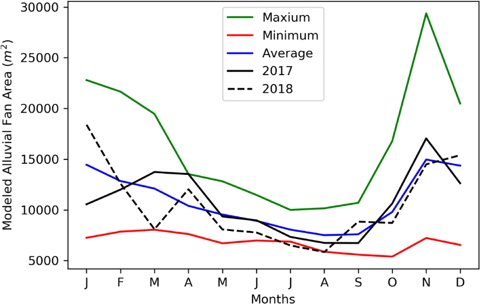
Seasonal patterns of minimum water coverage in AF area at the Robertson River site were assessed based on regression model estimates (Fig. 9). The seasonal average water level and the seasonal total precipitation at the North Cowichan weather station were also plotted to understand the effect of these on the water covered AF area. Note that the model is built only based on the water level and previous model indicated that precipitation at North Cowichan as second most important driver. When modelled over the entire time series (1982–2018), there is variation within a season and as expected, between seasons. Modelled water coverage of the minimum AF area in the free-flow season (October–March) varied between 7247 and 10 131 m2 (average 8731 m2) with a total precipitation variation of 445–1674 mm (average 927 mm) and average water level variations of 1.22–2.19 m (average 1.8 m). Modelled water coverage of the AF varied between 7338 and 9865 m2 (average 8809 m2) with a total precipitation variation of 36–289 mm (average 162 mm) and average water level variation of 1.08–1.77 m (average 1.5 m) in storage season (April–June), between 5514 and 8446 m2 (average 6965 m2) with a total precipitation variation of 26–322 mm (average 144 mm) in regulated season and average water level variation of 0.66–1.5 m (average 1 m) (September–November). Due to geo-referencing issues, this analysis was only conducted at the Robertson River study site. Images were also taken in both 2017 and 2018 in two other locations, Cottonwood and Shaw creeks (Figs. S1 and S2), which, although difficult to compare quantitatively, tend to show overall higher levels of inundation (i.e., water coverage of alluvial fan area) in 2017 compared to 2018.
Fig. 9.
4. Discussion
The relationship between the AF area and lake water level reveals the control of weir regulation on the water coverage of habitat area. The results demonstrate the marked low water-covered AF area during the regulated season of 2018. However, the precipitation time series doesn’t show any anomalies in this season or prior (Fig. 9b). Winter precipitation, which is one of the major sources of water in this area, was also within normal variation. This reduction of AF area came from the reduction of water level which again depends on the water level during the storage season. So, under normal rainfall conditions, the water level during the regulated season and in turn water level during the storage season, resulted in the marked reduction of AF area. The separation in the modelled and observed minimum water level evident in Fig. 7c suggests that extreme low water levels in recent years cannot be attributed to rainfall and (or) snowmelt factors alone, since the storage season water level was not particularly low. It may be that evaporative loss due to summer warming could be impacting water levels in recent years, exacerbating critical threats to lamprey nearshore habitat areas.
Furthermore, the water level during the storage season is of primary importance because it also has greatest control on the water level during regulation season. During these two seasons, it is assumed that the lamprey are spawning and rearing. Therefore, for the continued persistence of the species, it is important to maintain the water level in the storage season. The recent decrease in precipitation demands a careful consideration of the regulation strategies. One solution to prevent the decrease in water level during the storage season and in turn regulation season can be early closing of weir gate during the free-flow season. This will essentially store enough water to sustain spawning and early rearing habitat. However, greater storage during the high-flow season may result in a reduction in downstream river flow with potential negative effects for river dwelling species. Recent proposals to rebuild the weir to a higher height would improve the water resource issues which are impacting lamprey habitat during this critical period (storage season).
The reduction in spawning and early rearing habitat demonstrated in this study at Robertson River in 2018 in conjunction with a reduction in lake height is akin to that seen at the other two locations; this is demonstrated in June (Fig. S1) and September (Fig. S2). These images provide some evidence that similar processes are occurring at other sites around the lake.
During July and August 2018, the minimum areal coverages were 64% and 53% and water levels were 0.98 and 0.6 m, respectively. During July and August 2017, the minimum areal coverages were 73% and 62% with water levels 1.3 and 1.01 m, respectively. We were successful in catching lamprey in spawning condition in 2017 but not in 2018. Without going into statistical inference owing to lack of data, we can at least qualitatively say that the water level in 2018 was not suitable (i.e., dewatered) for lamprey spawning, whereas 2017 was suitable. This gives a qualitative limit for water level of approximately 1 m which provides enough coverage of the alluvial fan at Robertson River during this part of the spawning season to be available for spawning and early rearing. This water level recommendation needs to be further refined with the analysis of additional locations and spawning surveys.
According to our regression model, a water level of 1 m equates to 67% average areal coverage at the Robertson site (Fig. 6). Based on our field observations of lamprey when levels were lower than 1 m, this may be an important threshold for water coverage of spawning sites in the lake. To fully utilize the results of this study to inform the management of the weir in the control of lake height, it would be beneficial to develop a relative guide based on lake height and resulting AF coverage for multiple spawning locations. With the current study, it is reasonable to utilize the Robertson River spawning site as a representative location. The results of this study demonstrate that lake heights of 1.5 m result in 85% coverage of spawning habitat in this location, while 0.5 m lake height equates to 50% coverage. It is recognized that it may not be possible to balance the water needs of all species in all years, but this study demonstrates that water retention during the winter and spring is important to ensure accessible spawning habitat for the SARA-listed Cowichan Lake lamprey. The population-level consequences of not maintaining adequate coverage for successful spawning and early rearing on a year-to-year basis are unknown. It is likely that intermitted years of poor recruitment will not cause catastrophic population-level effects due to the extended larval period of the species; however, if winters of little precipitation, summer droughts and increased water extraction become the norm these will likely have significant negative impacts on the survival of the species.
Our recommendations regarding weir control procedure for conservation are:
1.
As lake water level differs considerably between years, the weir control protocols should be flexible to account for extremes.
2.
Weir control should employ comprehensive, whole ecosystem-focused methods (Acreman 2003; Acreman and Dunbar 2004); therefore, it is recommended that they should consider the spawning and rearing requirements of Cowichan Lake lamprey.
3.
Regulation of the weir should aim to ensure that the water level remains above the 1 m mark, which equates to 67% coverage of water on the AF area. Increasing the height of the weir to increase storage season capacity is one way to achieve this.
Conserving critical habitat that is dynamic in nature and subject to competing conservation and social or economic priorities requires careful consideration of crucial seasonally determined life stage and habitat requirements. Our work in this manuscript provides this information for Cowichan Lake lamprey through extensive field survey and careful modeling of different drivers related to Cowichan Lake lamprey spawning area.
Acknowledgements
This work was funded in part by the Global Water Futures research programme and, the Species at Risk Program of Fisheries and Oceans Canada, Science, Pacific Region. Thank you to Vanessa Hodes, Lindsay Dealy, and Craig Stephen for field assistance.
References
Acreman MC. 2003. Case studies of managed flood releases. Environmental flows assessment Part III. World Bank Water Resources and Environment Management Best Practice Brief No. 8. World Bank, Washington, D.C.
Acreman MC, and Dunbar MJ. 2004. Defining environmental river flow requirements—a review. Hydrology and Earth System Sciences, 8: 861–876.
Arthington AH. 1998. Comparative evaluation of environmental flow assessment techniques: review of holistic methodologies. LWRRDC Occasional Paper No. 26/98. Land and Water Resources Research and Development Corporation, Canberra, Australia. 46 p.
Arthington AH, and Pusey BJ. 2003. Flow restoration and protection in Australian rivers. River Research and Applications, 19: 377–395.
Arthington AH, Dulvy NK, Gladstone W, and Winfield IJ. 2016. Fish conservation in freshwater and marine realms: status, threats and management. Aquatic Conservation: Marine and Freshwater Ecosystems, 26: 838–857.
BC Lake Stewardship Society. 2014. BC Lake Stewardship and Monitoring Program. Cowichan Lake Report 2004–2013. Cowichan Watershed Board, Kelowna, BC.
Beamish RJ. 1982. Lampetra macrostoma, a new species of freshwater parasitic lamprey from the west coast of Canada. Canadian Journal of Fisheries and Aquatic Sciences, 39: 736–747.
Beamish RJ, and Wade J. 2008. Critical habitat and the conservation ecology of the freshwater parasitic lamprey, Lampetra macrostoma. The Canadian Field-Naturalist, 122(4): 327–337.
Camaclang AE, Maron M, Martin G, and Possingham HP. 2015. Current practices in the identification of critical habitat for threatened species. Conservation Biology, 29: 482–492.
Department of Fisheries and Oceans Canada (DFO). 2007. Recovery strategy for Vancouver lamprey (Lampetra macrostoma) in Canada. Species at Risk Act Recovery Strategy Series. Fisheries and Oceans Canada, Ottawa, Ontario.
Department of Fisheries and Oceans Canada (DFO). 2016. Report on the progress of recovery strategy implementation for Cowichan Lake Lamprey (Entosphenus macrostomus) in Canada for the period 2007–2015. Species at Risk Act Recovery Strategy Report Series. Fisheries and Oceans Canada, Ottawa. iii + 12 pp.
Farrar DE, and Glauber RR. 1967. Multicollinearity in regression analysis: the problem revisited. The Review of Economics and Statistics, 49(1): 92–107.
Lorion CM, Markle DF, Reid SB, and Docker MF. 2000. Redescription of the presumed-extinct Miller Lake lamprey, Lampetra minima. Copeia, 2000(4): 1019–1028.
MacConnachie SEM, and Wade J. 2016. Information in support of the identification of critical habitat for the Cowichan (Vancouver) lamprey (Entosphenus macrostomus). Research Document 2016/109. DFO Canadian Science Advisory Secretariat, Ottawa, Ontario.
MacKay DJC. 1992. Bayesian interpolation. Neural Computation, 4: 415–447.
Martin TG, Camaclang AE, Possingham HP, Maguire LA, and Chadès I. 2017. Timing of protection of critical habitat matters. Conservation Letters, 10: 308–316.
Stephen C, and Wade J. 2018. Wildlife population welfare as coherence between adapted capacities and environmental realities: a case study of threatened lamprey on Vancouver Island. Frontiers in Veterinary Science, 5: 227.
Tipping ME. 2001. Sparse Bayesian learning and the relevance vector machine. Journal of Machine Learning Research, 1: 211–244.
Vancouver Lamprey Recovery Team. 2007. Recovery strategy for the Vancouver lamprey (Lampetra macrostoma) in Canada. Species at Risk Act Recovery Strategy Series. Fisheries and Oceans Canada, Ottawa, Ontario. ix + 21 p.
Wade J. 2017. Field report: trapping of Cowichan Lamprey (Entosphenus macrostomus) in Cowichan and Bear Lakes 2017. Prepared for the British Columbia Conservation Foundation, Nanaimo, BC. 22 p.
Wade J. 2019. Can we learn from other freshwater parasitic lampreys to help manage Cowichan Lake Lamprey (Entosphenus macrostomus). Canadian Manuscript Report of Fisheries and Aquatic Sciences 3184. v + 29 p.
Wade J, Dealy L, and MacConnachie S. 2018a. First record of nest building, spawning and sexual dimorphism in the threatened Cowichan Lake lamprey Entosphenus macrostomus. Endangered Species Research, 35: 39–45.
Wade J, Dealy L, Hodes V, and Grant P. 2018b. Identifying factors contributing to the successful spawning and early rearing of cowichan lake lamprey (Entosphenus macrostomus). Canadian Manuscript Report of Fisheries and Aquatic Sciences 3169. v + 13 p.
Weir Operation Guidelines. 2016. [online]: Available from catalystpaper.com/sites/default/files/node_uploads/page/attachments/cowichan_weir_operating_guidelines.pdf
Supplementary material
Supplementary Material 1 (DOCX / 6.21 MB).
- Download
- 6.22 MB
Information & Authors
Information
Published In
FACETS
Volume 5 • Number 1 • January 2020
Pages: 488 - 502
Editor: Brett Favaro
History
Received: 23 September 2019
Accepted: 14 April 2020
Version of record online: 29 June 2020
Copyright
© 2020 Chaudhuri et al. This work is licensed under a Creative Commons Attribution 4.0 International License (CC BY 4.0), which permits unrestricted use, distribution, and reproduction in any medium, provided the original author(s) and source are credited.
Data Availability Statement
All relevant data are within the paper and in the Supplementary Material.
Key Words
Sections
Subjects
Authors
Author Contributions
All conceived and designed the study.
All performed the experiments/collected the data.
All analyzed and interpreted the data.
All contributed resources.
All drafted or revised the manuscript.
Competing Interests
The authors have declared that no competing interests exist.
Metrics & Citations
Metrics
Other Metrics
Citations
Cite As
Chiranjib Chaudhuri, Joy Wade, and Colin Robertson. 2020. Fluctuating water levels influence access to critical habitats for threatened Cowichan Lake lamprey. FACETS.
5(1): 488-502. https://doi.org/10.1139/facets-2019-0054
Export Citations
If you have the appropriate software installed, you can download article citation data to the citation manager of your choice. Simply select your manager software from the list below and click Download.
There are no citations for this item