Communicating complexity: interactive model explorers and immersive visualizations as tools for local planning and community engagement
Abstract
Models that capture relationships between a variety of social, economic, and environmental factors are useful tools for community planning; however, they are often complex and difficult for diverse audiences to understand. This creates challenges for participatory planning and community engagement. Conducted in the community of Squamish (British Columbia, Canada), this study develops and examines tools for communicating outcomes of a community scenario modelling exercise to diverse stakeholders. These tools are (i) a “model explorer” and (ii) realistic, immersive visualizations. The model explorer is an online, HTML5-based tool that can be used to learn about the model, view community scenario maps, and explore potential outcomes of the scenarios. The visualizations are virtual environments that are navigated from the first-person perspective, and they were developed using a combination of ArcGIS, Trimble SketchUp, Adobe Photoshop, and the Unity3D game engine. A local government and community stakeholder focus group and public open house event were held to solicit feedback on the scenarios and tools. Findings of the research suggest that the two types of tools can be used in a complementary fashion, and tool integration can better harness their respective strengths in a manner that comprehensively communicates the implications of different development pathways to diverse community members.
1. Introduction
Sustainable community development requires reconciliation of social, economic, and environmental imperatives (Dale 2001; Newman and Jennings 2008; Rydin 2010); therefore, it is best performed through integrated approaches that recognize how plans, polices, and strategies link to broader goals for humans and the environment (Ling et al. 2009; Shaw et al. 2014; Dale et al. 2018). Significant advancements in computation and modelling have led to sophisticated tools that can be used to understand the complex, interrelated considerations involved in land use and community development (Almeida et al. 2009; Chase et al. 2010; Keirstead and Sivakumar 2012), and accordingly, these tools can support integrated planning efforts (Newell et al. 2018, 2020). Models can be used to elucidate a variety of different outcomes associated with community plans and strategies, such as transportation effectiveness, land use efficiency, energy consumption, water consumption and conservation, and (or) greenhouse gas emissions (e.g., Salvini and Miller 2005; Wagner and Wegener 2007; Eluru et al. 2008; Frank et al. 2009; Sperling and Berke 2017). However, because of their complexity, it can be difficult for diverse users and stakeholders to interpret and fully understand the implications of model outputs (Newell and Picketts 2020a, 2020b), thereby presenting a need for complementary tools that clearly communicate these outputs and allow for effective exploration and understanding of model outcomes. This research explores such communication tools, namely an interactive “model explorer” and realistic visualizations, to examine their potential as tools for supporting participatory processes and community engagement in integrated planning.
Stakeholder participation is widely recognized as an integral component of effective planning processes (Raymond and Brown 2007; Robinson et al. 2011; Sheppard et al. 2011). Governance is most effective when done in cooperation with those that experience its associated problems and opportunities (Jentoft and Chuenpagdee 2009), and stakeholder participation in community planning ensures a plan is grounded in local realities and the appropriate social, cultural, political, economic, and environmental contexts (Ling et al. 2009). Accordingly, tools for effectively engaging stakeholders and community members are invaluable for effective planning. Although models have potential for supporting integrated community planning, these tools often experience an “implementation gap”, meaning that the insights and knowledge gained through the tools are not often effectively put into practice (Silva et al. 2017). A major contributor to this gap is a lack of attention to the user experience, or how users interact with the tools and gain insights from model outputs (Russo et al. 2015). Therefore, if models are to be effective tools for communicating to the public, they need to be approachable, usable, and developed in accordance with the needs of the intended users.
A number of different approaches and techniques exist for communicating outcomes of modelling exercises to diverse community members. One approach involves creating a clear, intuitive, and engaging interface that allows users to explore these outcomes, referred to in this research as a “model explorer”. For example, Summers et al. (2015) developed the Landscape Futures Analysis Tool, which communicated agricultural production, carbon sequestration, and biodiversity conservation implications of different land management decisions through a user interface for exploring management scenarios, maps, and data. Another effective communication technique involves the use of realistic visualizations that convey different environmental management and (or) community development scenarios to provide people with a strong impression of “potential futures” that could transpire if certain plans or strategies were implemented. Because of their realism, these tools can convey complex information in a salient manner to diverse groups and provide a vivid understanding of how one would react to the implementation of different planning decisions (Sheppard 2001; Newell and Canessa 2015; Newell et al. 2017a, 2017b). Previous research has found that visualizations show promise as effective tools for planning and stakeholder engagement, with studies that have demonstrated their application in climate adaptation planning (Sheppard et al. 2011), natural resource management (Lewis and Sheppard 2006), stakeholder engagement in land-use planning (Schroth et al. 2011), community development and residential expansion (Salter et al. 2009), urban green space planning (Grêt-Regamey et al. 2013), and local and regional development (Tress and Tress 2003). One of the reasons visualizations serve as effective tools for planning is because they connect with people’s sense of place (Newell and Canessa 2015, 2017; Newell et al. 2017a), and this allows users to engage with aspects of management and development plans that are difficult to convey though quantitative data or model outputs, such as impacts to viewsheds and changes to the character of a place (Newell et al. 2017b, 2018). The application of realistic visualizations may be beneficial in identifying and harmonizing the values of citizens and governments in urban planning initiatives, contributing to a robust local sense of community and place.
Although interactive interfaces and visualizations have exhibited promise as effective tools for participatory planning and community engagement, often they are developed only by researchers and (or) practitioners, whereas a truly participatory planning process would involve broader community involvement and values in the design of models and scenarios (Prell et al. 2007; Woodward et al. 2008; Amer et al. 2013). Such involvement would lead to models and communication tools that reflect a range of different concerns, needs, and interests associated with different management options and community development pathways. Clark et al. (2016) discussed how the production of usable knowledge through technology-based tools has been constrained by one-directional, expert-driven process, whereas collaborative, iterative approaches that result in co-production are more effective for strengthening relationships between knowledge-making and decision-making. A critical (but challenging) aspect of effective participatory scenario planning is to develop and improve processes for translating of stakeholder values, narratives, and visions into information that can be captured in models and other planning tools (Scolobig and Lilliestam 2016). In addition, it is important to recognize that a variety of different types of planning and engagement tools exist, each with their own limitations, and they cannot simply be substituted for one another (Lewis and Sheppard 2006). When developing and evaluating the utility and effectiveness of digital tools, McNamara and Kirakowski (2006) recommended considering their functionality, meaning “what does the product do?” (p. 26); in the case planning tools such as maps, visualizations, and data, these tools have different functions that allow people engage in planning information and exercises in different ways (Newell et al. 2017b). It is, therefore, important to understand how these tools can be used in a complementary fashion to optimize their potential for supporting planning processes. Ultimately, although advancements have been made in research on participatory planning and community engagement tools, knowledge gaps still exist, particularly in terms of how to develop appropriate tools based on broad community interests and objectives and how to effectively use them in a complementary manner.
This study develops and examines two tools designed to support participation and engagement in community planning, that is, an interactive model explorer and realistic visualizations. The study is part of a larger project, “Spaces, Places and Possibilities”, which involves three phases: (i) designing community scenarios and model based on local government and stakeholder input; (ii) using the model to calculate/estimate possible social, economic, and environmental outcomes of the scenarios; and (iii) creating tools for communicating the model and scenarios to diverse community members and the broader public. This paper focuses on the third research phase, and it discusses the development of the model explorer and visualizations, as well as their assessment through focus group and open house activities. The other research phases are documented in publications (Newell and Picketts 2020b; Newell et al. 2020), project reports (Newell and Picketts 2018, 2019a, 2019b, 2020a), and on the project webpage: crcresearch.org/spaces-places-and-possibilities.
2. Methods
2.1. Study site
The District of Squamish is a town of 20 000 people in southwestern British Columbia, Canada, located approximately 50 km north of the City of Vancouver on the traditional territory of the Squamish Nation (Fig. 1). The region has a complex geography, being located at the terminus of Howe Sound at the Pacific Ocean and in the Coast Mountain range. The geography constrains growth and increases natural hazards, while also providing a multitude of outdoor recreational opportunities and aesthetic landscape views.
Fig. 1.
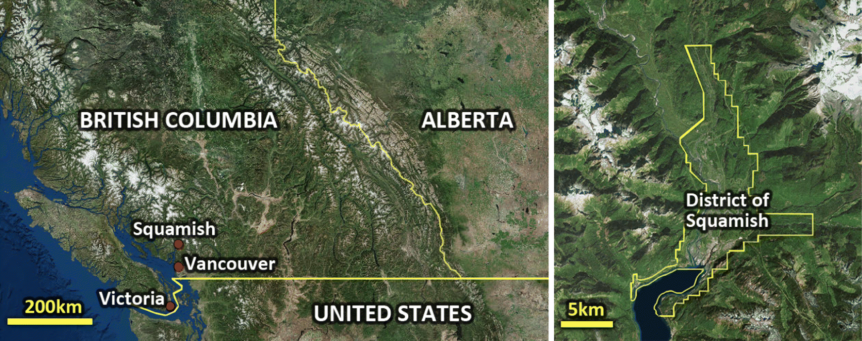
Squamish is currently experiencing rapid population growth, largely due to its proximity to Vancouver. People who work in Vancouver’s metropolitan area can commute from Squamish, thus providing an attractive “small town” (and less expensive) option for residency. Accommodating rapid growth within the town’s geographical limitations is one of the major planning challenges the community of Squamish faces (District of Squamish 2017). Coupled with population sprawl and limited service infrastructure, the region’s planning strategy focuses on increasing accessibility to services and amenities. However, the logistical demand for increased-density development runs contrary to the region’s cultural relationship with wilderness and private, single-family housing. Such challenges highlight the value of Squamish as a case study for integrated planning research; however, these circumstances are not unique to the municipality and are broadly applicable to a variety of rapidly growing communities.
2.2. Scenario modelling
The scenario modelling exercise done for this research was conducted in previous phases of the project; thus, it is not detailed in this paper. However, a summary of the modelling activities is included below to provide context for the current study on developing and examining tools for communicating model outcomes. For more information on the previous research phases, refer to Newell et al. (2020) and Newell and Picketts (2018, 2019a, 2019b, 2020a, 2020b).
The modelling process first involved developing a community systems model to capture relationships between planning challenges, development strategies, and community outcomes, and scenarios were defined to identify potential “futures” for Squamish (i.e., plausible ways the community could develop). The model and scenarios were developed through two focus groups, consisting of (i) a preliminary project scoping meeting with four members of the District of Squamish’s Community Planning and Infrastructure Department and (ii) a broader community stakeholder meeting that included 12 participants from nongovernmental organizations (NGOs), local government, business interests, development, public transportation, and academia.
The systems model was applied in an integrated modelling exercise that calculated indicators for potential social, economic, and environmental outcomes of different development directions. A series of calculations were conducted primarily using ArcGIS (version 10.6) and R (version 3.6.0) software, and the relationships and elements in the systems model informed what and how community outcomes should be measured/calculated. A review of academic and grey literature identified a series of relevant measurement methods, and these were applied to estimate outputs and indicators for each of the scenarios. Once the scenarios were modelled, another local government and community stakeholder focus group was held to gain feedback on the results of the modelling exercise; 15 participants attended this session, with about half of them being new to the project. The systems model and community scenarios (Table 1) were refined based on the feedback, and the modelling exercise was conducted again using the refined model and scenarios.
Table 1.
| Scenario | Description |
|---|---|
| Low-density residential neighbourhoods | New residential neighbourhoods are developed with single-family detached houses and do not contain mixed-use or commercial buildings. Current residential areas are not redeveloped through infill and densification, and instead, undeveloped areas outside Squamish’s growth management boundaries are used for residential growth. |
| Medium-density neighbourhoods and enhanced agriculture | Residential neighbourhoods are redeveloped to consist of a mix of duplexes, multiplexes, small houses, townhouses, and semi-detached houses. Densification primarily occurs in existing residential areas, but some hillside areas are also developed to reserve valley floor space for agriculture while also accommodating population growth. |
| High-density neighbourhood nodes | Residential areas are redeveloped as walkable neighbourhood communities with local businesses and amenities. New development consists of mixed-use apartment buildings, townhouses, and duplexes. Densification occurs near public transit routes to increase transit access and viability. |
Population growth is the main driver of effects in and dynamics of the model, and it was kept consistent across all three scenarios (i.e., all scenarios assumed the same future population size). Land availability is the major constraint in the model; developing community land presents considerations around how to balance competing land uses, such as residential, commercial, agricultural, and green space (i.e., parks and natural spaces). Development strategies were explored in the model, and these included densification, mixed-use development, corridor development, smaller houses, etc. The strategies have implications for a variety of community outcomes, such as access to schools, food and farm systems, local employment, access to green spaces, walkability, health, threats to habitat, etc. A list of the different systems model elements is given in Table 2, and graphical depictions of the model and relationships between the elements can be found in Newell and Picketts (2019b).
Table 2.
| Element type | Model elements |
|---|---|
| Model driver | Population growth |
| Model constraint | Land availability |
| Land uses | Agricultural space, commercial space, green space, residential space |
| Local development strategies | Corridor development, hill and slope development, local businesses, missing middle, mixed housing types, mixed-use development, reduced traffic and commuting, smaller houses, transit accessibility |
| Community outcomes | Access to amenities, access to green space, access to schools, affordability, air quality, biodiversity, carbon sequestration, density, floodplain management, food and farm, greenhouse gas reductions, habitat, health, local employment, social diversity, viewshed, walkability, wildfire management |
Scenario modelling firstly involved mapping the “current conditions” of Squamish in ArcGIS to create a baseline scenario for the community. The mapping used data from Statistics Canada, the District of Squamish’s Open Data Portal, and other sources (Newell and Picketts 2019a, 2019b), and it included distributions of housing types and residents, commercial space and employee numbers, businesses, local amenities, neighbourhood boundaries, schools and public school catchment areas, parks, natural areas and sensitive habitat, lowland floodplain areas, wildfire risk zones, gardens, agricultural land, transit routes, and bus stops. Squamish has plans for future developments, and these were also mapped to make the community scenarios more relevant to Squamish’s “future conditions” (District of Squamish 2015, n.d.). New development included residential buildings that have been approved for development, commercial land (and associated local employment opportunities), new transit routes to service growing areas, and new schools.
The community development scenarios were built upon the future conditions baseline, and each scenario targeted a population of 34 000, as per a local growth projection given by the District of Squamish (2017) that estimates this population level will be reached by 2036. The future conditions scenario can accommodate approximately 29 900 people; thus, scenario modelling involved distributing 4100 people around the community in different ways. Particular neighbourhoods of interests for future development planning were identified through discussions with local government and community stakeholders, and these were the foci of the scenario mapping and modelling.
2.3. Communication tools development and assessment
The research developed two tools for communicating the model outcomes and scenarios, namely an interactive model explorer and scenario visualizations. The purpose of creating the tools was to provide a means for communicating complex data and the output produced through the scenario modelling exercise to diverse community members. Accordingly, the effectiveness of the tools were assessed through a community focus group and open house event, following the methodology of other studies that research online interactive tools (e.g., Herring et al. 2016; Newell et al. 2016) and visualizations (e.g., Tress and Tress 2003; Schroth et al. 2009, 2011; Newell et al. 2017a, 2017b). The following sections describe the development and features of the model explorer and visualization tools, the assessment of the tools using focus group and open house methodology, and the analysis of the data produced through the focus group and open house event.
2.3.1. Model explorer
The model explorer is an HTML5-based interactive interface for engaging with the model. The tool is navigated using a mouse, and it can be used to learn about how the model was created, view community scenario maps, and explore potential outcomes of developing the community of Squamish in different ways. The model explorer is available online, and it can be accessed here: changingtheconversation.ca/model-explorer.
When accessing the model explorer, users first encounter an introduction page that summarizes the purpose of the research project and explorer tool. After clicking an “enter model explorer” button, users are given options to navigate to the three different sections of the explorer: (i) About the Model, (ii) Scenario Maps, and (iii) Model Outcomes. The About the Model section provides information on how the community scenario modelling exercise was done, and it describes the different steps of the modelling process. It also describes the mapping that was done for the current and future baseline scenarios, and it gives detail on the features and development approaches of the different community scenarios.
The Scenario Maps section of the model explorer provides detailed information on, and views of, the development characteristics and features of the different community scenarios. Users can view maps of areas that were developed/redeveloped for the different scenarios, identified and highlighted using map overlays, and labels of their respective community development features (Fig. 2). When users first enter the Scenario Maps section, the neighbourhoods that served as the foci of the modelling exercise (i.e., places of interests for future development planning identified through the focus groups) are highlighted on a full map of the District of Squamish, and users can click on them to zoom in and explore different scenario maps. Most of the neighbourhood maps cover areas of approximately 1.25 km × 1.25 km, with the exception of an area of 5.5 km × 5.5 km located outside of Squamish’s growth management boundaries that served as the site for a hypothetical new neighbourhood in the low-density residential neighbourhood scenario. Users can also access a summary table in this section, which gives local populations and total areas of residential development/redevelopment in the neighbourhoods for each of the scenarios.
Fig. 2.

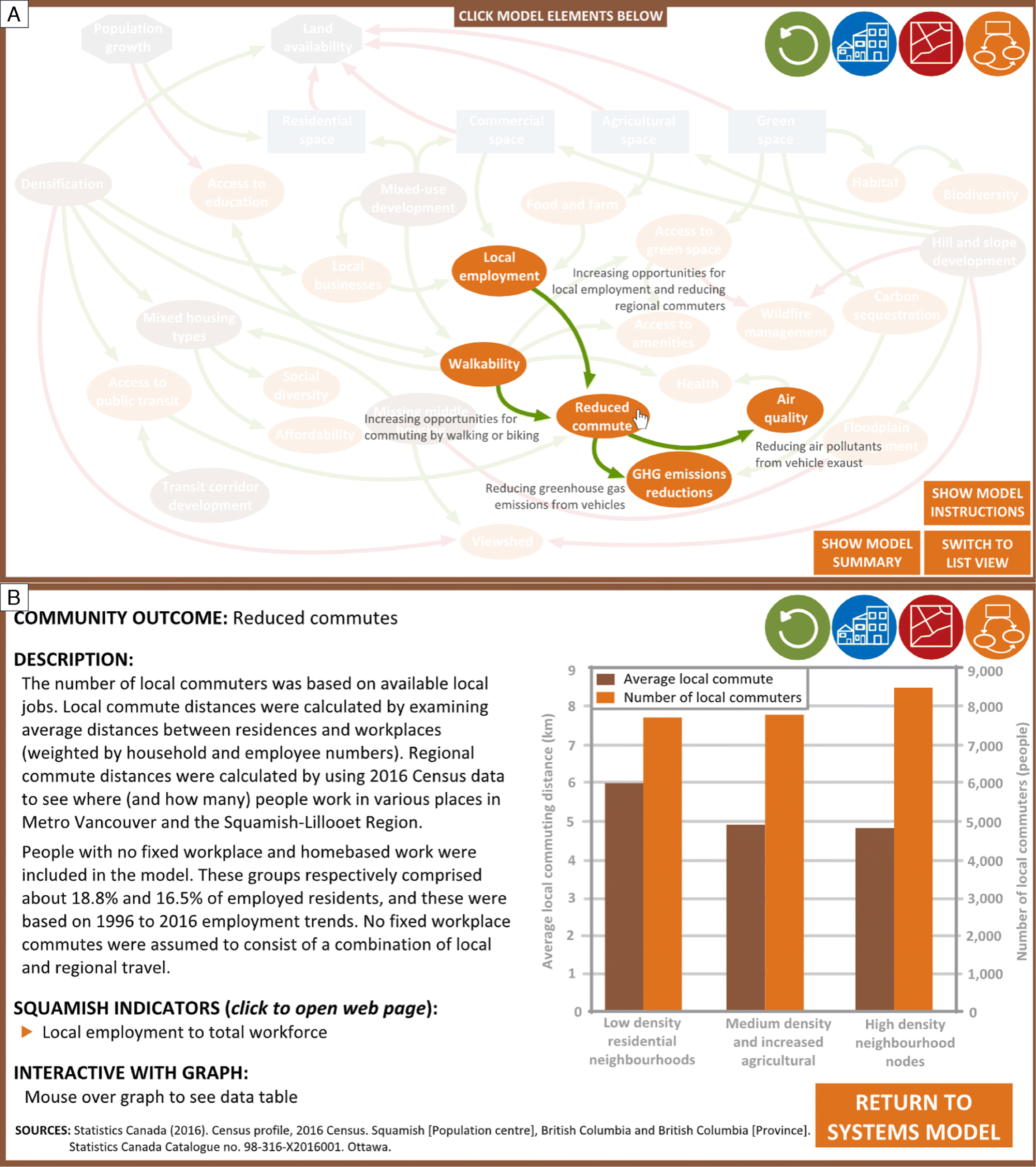
The Model Outcomes section of the model explorer presents the various social, economic, and environmental indicators estimated for each of the community development scenarios, as well as information on how these outputs were calculated. Users interact with the community systems model by moving their cursor over the model elements to see systems relationships between these elements (Fig. 3). Clicking on the elements will open pages that display information, graphs, and (or) tables on a respective model driver, model constraint, land use, development strategy, or community outcome. Where applicable, the pages contain links to related Squamish Community Performance Indicators (District of Squamish 2019) to present the relevance of the model to Squamish’s community sustainability goals.
Fig. 3.
2.3.2. Visualizations
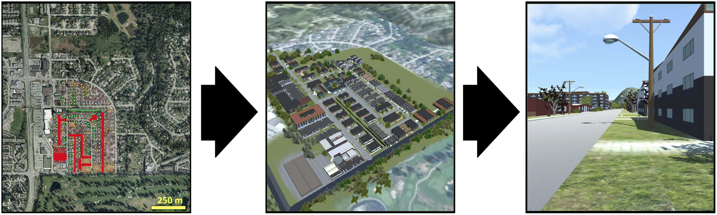
The type of visualizations created through this research take the form of realistic, immersive, virtual environments that are experienced from the first-person perspective. Users can digitally “walk through” the visualizations and view the scenarios to gain impressions and place-based understandings around what the scenarios would look and “feel” like if implemented in the community (Newell and Canessa 2015). Sounds were added to the virtual environment, drawing upon previous research that has found soundscapes can enhance a visualization’s ability to resemble a real-world place (Lindquist et al. 2016; Newell et al. 2017a). Detailed information on the visualization development process can be found in the Supplementary Materials, and the visualization application is available for download from the project website: crcresearch.org/spaces-places-and-possibilities#visualization.
Visualizations were created for two of the focal neighbourhoods used in the modelling exercise: a low-density suburban residential neighbourhood and a rural residential neighbourhood. After developing baseline representations of the neighbourhoods (i.e., the current conditions), the terrain, objects, and textures modelled for the baseline scenarios were copied and modified to resemble the different community development scenarios. As explained in Section 2.2., maps of the scenarios were created for the modelling exercise (Newell and Picketts 2019a, 2019b), and these maps were used to create “reference maps” for the scenario visualizations (Fig. 4), which are maps that contain orthophoto and (or) vector data of different structures and features of the neighbourhoods and are used to guide placement of objects and textures (Newell et al. 2017a). It is worth noting that the neighbourhoods in the low-density scenario did not differ from the baseline scenario in terms of density or dwelling type (i.e., single-family detached houses); however, in the visualization, low-density did not represent a “no change” scenario. Redevelopment is expected to occur in the community regardless of density changes; thus, in the low-density scenario, some houses were replaced with a more modern design.
Fig. 4.
In the modelling exercise, scenario mapping involved placing dwellings and people within land parcels based on dwelling unit per area densities for different dwelling types (e.g., Parolek 2016). The mix of housing types used for the medium-density scenario resulted in an average density of 42 units/ha in redeveloped parcels; however, the mapping done in the scenario modelling occurred at the parcel level and it did not include the necessary/likely road and path infrastructure for accessing these units. This infrastructure was added to the visualizations, ultimately reducing parcel space available for residential units in the medium-density scenario, and 25 units or approximately 60 residents were removed from the suburban residential neighbourhood visualization. This issue was particular to the medium-density scenario and visualizing the high-density scenario did not result in loss of units. The high-density scenario was mapped with the assumption that apartments and mixed-use building footprints will at most take 50% of parcels to leave room for parking and common spaces, and this approach also provided parcel space for new access routes.
Scenario visualization also involved making changes to animated objects to capture potential differences in local vehicle and pedestrian traffic. Such changes were done based on the assumption that local traffic will increase due to population growth. It was difficult to make exact predictions on what the local traffic would be for the scenarios because it is dependent on a number of community-wide factors, such as popular travel routes and commercial destinations. Therefore, for this research, only rough estimates around traffic changes were calculated, and these were (for the most part) based on changes in neighbourhood populations. Some qualitative judgements on traffic levels were also made on a case-by-case basis; for example, the low-density residential neighbourhoods visualization depicted a traffic increase on a road that would serve as the primary route for a hypothetical new neighbourhood development.
Other elements added to scenario visualizations were those that captured key aspects of a given scenario’s “story”; for example, the medium-density and enhanced agriculture scenario featured signs and tractors in the rural residential neighbourhood visualization. The scenario involved reserving more valley floor space in this neighbourhood for developing local food and farm systems, and these objects signalled that a significant part of the area was being used for agricultural purposes. As another example, groups of socializing people were added to parks and public spaces in commercial centres to signify that these would be places of public use, community gathering, and social interaction.
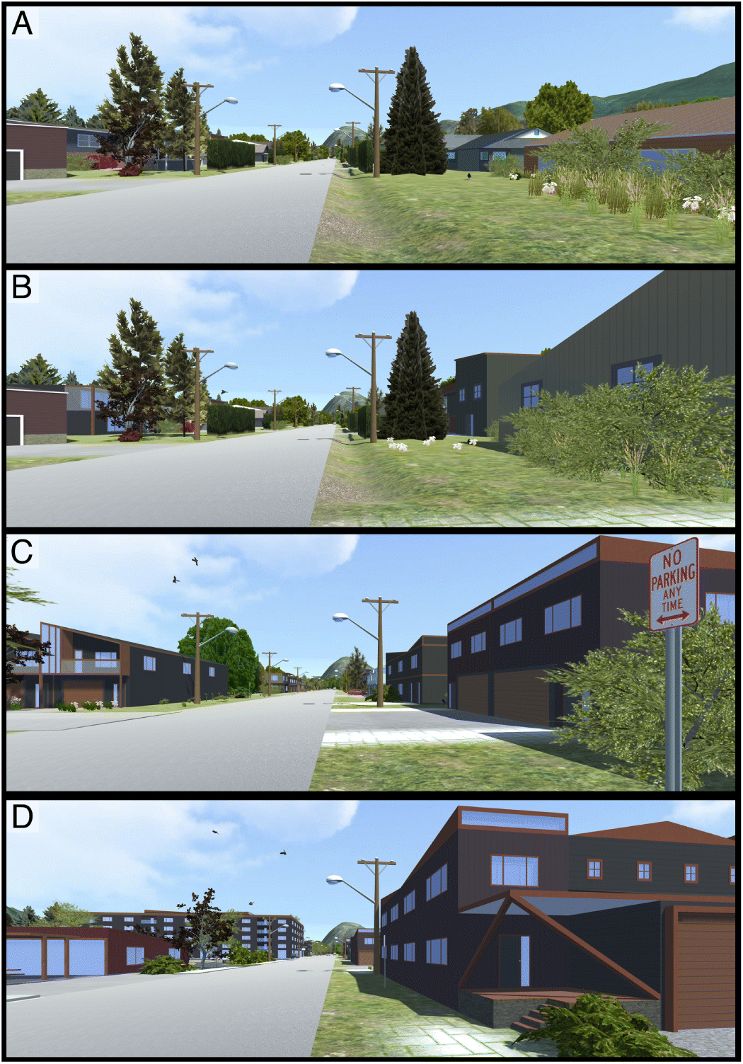
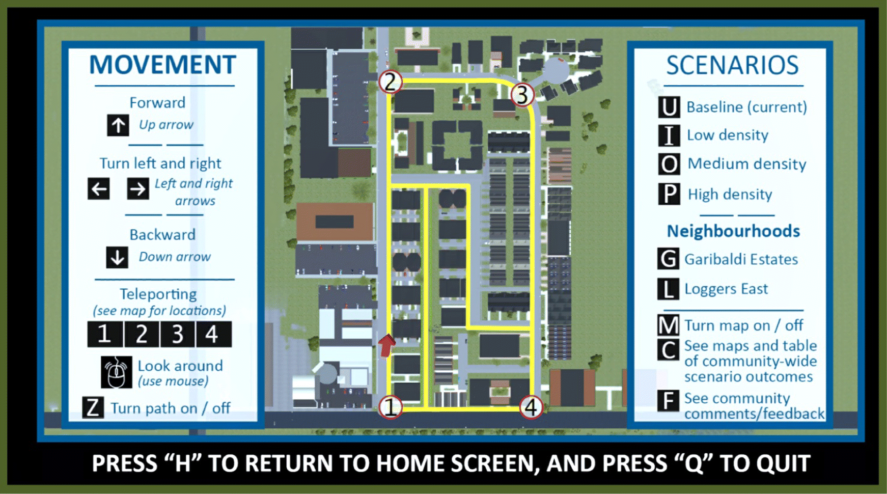
Visualization users toggle different scenarios using key commands (Fig. 5), and this function allows them to clearly compare different local development patterns and options. Visualization users are restricted to particular walking routes (which could be highlighted using a key command), and for each neighbourhood visualization, users can walk through an area that approximately covers the size of a neighbourhood block. The purpose of restricting user movement is two-fold: (i) it gives users a (somewhat) guided experience that better highlights significant changes between scenarios, and (ii) it allows for a more “economical” build of the visualizations, involving strategic exclusions of unnecessary objects and textures.
Fig. 5.
In addition to the first-perspective perspective views, users can explore scenarios through a “map view” (Fig. 6). The map view helps users orient themselves within the visualizations, and it displays locations that can be teleported to using key commands (allowing for easier access to different areas within the virtual environments). The “map view” also contains instructions for the different key commands for using the visualization and exploring scenarios.
Fig. 6.
2.3.3. Community focus group
The focus group was comprised of local government and community stakeholders. Recruitment involved contacting people that had previously participated in the project, as well as snowball sampling (i.e., some previous participants suggested other potential participants). In total, 28 people were invited to the focus group through an e-mail recruitment letter, 12 accepted, and 9 attended. Most of the attendees had previously participated in the research, but 2 were new to the project. Albeit a small group, it consisted of a mix of people from private, public, and NGO sectors, and it collectively represented a range of social, environmental, and economic interests associated with the development of the community. In this way, the study’s method follows other research involving small focus groups of people with specialized and relevant knowledge (Onwuegbuzie et al. 2009).
The focus group ran for 2 h. Before engaging in focus group activities, participants were provided with letters of consent, as per research ethics standards. Prior to commencing the project, a research ethics review was conducted and approved by the Research Ethics Board at Royal Roads University (under the project name: “Developing and using realistic interactive visualizations as tools for collaborative planning in communities”), and it was also approved by the Research Ethics Board at the collaborating institution, Quest University Canada (protocol number: 2018-0203). The letter of consent contained information on the purpose of the project, research methods, participant time commitment, rights and procedures for withdrawing from the study, dissemination of results, potential risks and inconveniences associated with participating, anonymity and confidentiality, data collection and storage, conflicts of interest (or lack thereof), and contact details for the researchers and the Research Ethics Board. Participants reviewed the letter, were given opportunities to ask questions, and then signed the letter to indicate their consent for participation in the research.
Following the signing and collection of letters of consent, the researchers gave a presentation on the research project and ran demonstrations of the model explorer and visualization tools. Participants were then invited to try out the tools independently, while the researchers made themselves available for questions and comments. After experimenting with the tools, the participants regrouped for a discussion guided by the following questions (participants were also given feedback forms to provide written comments on these questions):
•
What do the model explorer and visualizations tell you about the ways Squamish can develop and the potential implications of these development directions?
•
How do the model explorer and visualizations provide different insights and perspectives on the community scenarios? What information do you get from the model explorer but not the visualizations, and vice versa?
•
How effective are the model explorer and visualizations for helping you understand the implications of developing Squamish in different ways? What aspects of these tools are missing or could be improved?
•
Do you prefer either the model explorer or visualizations for gaining a better understanding of the scenarios (please explain why or why not)?
2.3.4. Open house event
Refinements to model explorer and visualizations were made based on the feedback provided by focus group participants, such as critiques of the tools and suggestions for improvement (see Section 3.2), and a public open house event was then held on the Quest University campus in Squamish. The purpose of the event was to broaden engagement beyond select focus group participants, and to give Squamish community members the opportunity to use the model explorer and visualization tools. The event was advertised through the local newspaper, community networks of the previous participants, and posters displayed throughout the town. Room set-up for the open house included posters with information on the research project and a series of computers made available for the attendees to try the model explorer and visualizations tools. Researchers were at the event to answer questions from the attendees.
Attendees were offered questionnaires that solicited feedback on the scenarios and the effectiveness of the model explorer and visualization tools. As per research ethics standards, participants were also provided with a letter of informed consent. The letters contained the same types of information as the letters of consent given to focus group participants, with the major exception being that open house participants were informed that submitting a completed questionnaire (rather than a signed form) indicated consent for participation. This change was made to the participant consent procedures due to the open house being less structured than the focus group, and an informed consent approach allowed participants to simply drop off completed questionnaires at their convenience.
The questionnaires provided Likert scale questions ranging from 1 to 10, which asked participants to assess both the scenarios and the communication tools. Participants were asked to rate the three community scenarios (1 = not a desirable future for Squamish; 10 = very desirable) and the usefulness of the tools for understanding and assessing the scenarios (1 = not useful at all; 10 = very useful). In addition, comments on the scenarios and tools were solicited through open-ended questions, including:
•
What do the model explorer and visualizations tell you about the ways Squamish can develop and the possible outcomes of these development directions?
•
Do the model explorer and visualizations provide different insights and perspectives on the community scenarios, and if so, explain these differences?
•
What aspects are missing or could be improved for the model explorer and the visualizations?
2.3.5. Data analysis
Feedback data from the focus group and open house event were examined to identify strengths and weaknesses of the model explorer and visualizations in terms of their potential uses as tools for community planning and public engagement. Several themes emerged from this feedback, and these are discussed below. Data consisted of transcripts of the focus group discussion, written comments provided through the focus group feedback forms, and comments provided through the open house event questionnaires.
The analysis primarily focused on qualitative data, and it employed thematic coding methodology (Seidel and Kelle 1995; Gibbs 2007), performed using the RQDA (version 0.3-1) package for R software. Focus group and open house data were analyzed separately. In both cases, inductive coding methods were used in a process that involved both applying and revising the coding framework as data were reviewed and analyzed (Thomas 2006).
The main purpose of the focus group data analysis was to identify common themes around the evaluation of the planning tools, including their strengths, critiques, and areas where they could be improved/refined. Similarly, the open house data were analyzed to identify common themes around strengths and weaknesses/limitations of the tools for planning and community engagement. In both cases, open coding was used, which involved reviewing the data to identify reoccurring ideas and common themes (Gibbs 2007). The process resulted in 14 codes applied to the focus group data and 17 codes applied to the open house data (Table 3). After the open coding stage was completed, an axial coding process was employed, which involved grouping coded data based on commonalities in themes and ideas (Simmons 2017). Through axial coding, a series of coherent themes emerged from the focus group and open house feedback, and these themes provide insights on the model explorer and visualizations in terms of their effectiveness as tools for community planning and public engagement.
Table 3.
| Data set | Codes |
|---|---|
| Focus group | Affordability, climate action, ecological values, highlighting key information, information summaries, tool integration, traffic and transportation, natural hazards, planning challenges, scale, types of information communicated, urban elements and design, user experience, user instructions |
| Open house event | Affordability, community livability, community values, expanding tool functionality, feasibility and plausibility, food and agriculture, green space, habitat and ecosystems, information complexity, land availability, planning support, public opinion, trade-offs, tool integration, traffic and transportation, types of information communicated, user experience |
3. Results
3.1. Focus group feedback
Eight themes emerged from the analysis of the focus group data. The themes provided insight on the effectiveness of model explorer and visualizations as tools for community planning and public engagement and potential ways of improving these tools. Descriptions of the themes are as follows.
Consider the tools as complementary but not substitutes for one another. Although some preferences were expressed for a particular tool, the model explorer and visualizations were (for the most part) described as communicating different information, rather than one being better than the other. Participants noted the strength of the model explorer to be that it provides extensive information on social, economic, and environmental implications of developing Squamish in certain ways, whereas the visualizations were described as useful for illuminating personal preferences for certain development approaches and urban forms. The model explorer was described as a tool for gaining “objective” understanding of the scenarios, whereas information conveyed through visualizations was described to be more “subjective”.
Integrate the model explorer and visualization. Focus group participants recommended strengthening the connection between the model explorer and visualizations. As noted above, the model explorer and visualizations communicate different information; thus, gaining a comprehensive understanding of the scenarios requires the use of both tools. However, participants noted that switching between the tools was not very convenient, and doing so disrupted continuity of thought. Accordingly, recommendations were made to integrate the tools, particularly in terms of adding features to the visualization that show how the model outcomes relate to the scenarios (e.g., pop-up windows with data and model outcomes).
Display scenarios at different scales. Participant feedback illuminated problems associated with reconciling different scales when using the model explorer and visualization tools to explore community development scenarios. This issue emerged when participants examined environmental outcomes related to the low-density residential neighbourhood scenario. The low-density scenario involves the development of residential neighbourhoods outside growth management boundaries, and as these areas currently consist of primarily natural spaces, the scenario resulted in relatively high values for indicators related to residential development encroaching on habitat. However, because the visualizations and scenario maps in the model explorer primarily focused on neighbourhoods and not the larger community scale, some participants were confused as to why low-density residential form (i.e., fewer people within redeveloped neighbourhoods) would result in greater overall encroachment on habitat. The issue demonstrated a need for highlighting community-wide changes associated with the scenarios in both the model explorer and visualization tools, in addition to the local changes.
Rethink the design of buildings and infrastructure. Developing visualizations with high degrees of realism requires making a number of decisions around the style and form of different models and elements within a virtual environment, such as the colour and shapes of houses, density and types of vegetation, presence and design of paths, etc. In this project, the researchers erred on the side of being conservative and not taking too many “creative liberties” when adding models/elements; however, in some cases, this approach impacted the realism and likelihood of aspects of the depictions. Participants noted that with high-density development, improvements would be made to infrastructure such as bike paths, streetlights, power lines, etc., and such improvements were not adequately captured in the visualizations. In addition, participants commented on the design of the residential dwellings, noting that new buildings would be designed differently and in accordance with floodplain considerations (e.g., elevated ground floors).
Highlight differences between scenarios. Focus group participants commented on how the model is quite information dense, and it would be useful to highlight significant differences between scenarios. It was suggested that the model explorer could present curated information that clearly conveys the benefits and trade-offs of the different scenarios. However, potential problems associated with taking such an approach were also discussed. Highlighting certain model outcomes and not others could unduly emphasize and ascribe value to particular social, economic, or environmental considerations. The tools aim to provide comprehensive understanding of the implications of different development directions, and their purpose is not to identify a “correct” development pathway. Regardless, the discussion indicated a need for a method of communicating a summary of scenario outcomes.
Communicate local planning concerns and challenges. The model explorer and visualizations did not capture all planning considerations and concerns associated with the different neighbourhoods, and participant feedback indicated that this could be problematic when using the tools to communicate planning options. For example, the rural residential neighbourhood has been the focus of conservation and restoration efforts, and it was expressed that the density scenarios and increases in local population could impact the area through higher levels of local traffic, recreation, and other human activity. These comments bring to light the need for community engagement tools that incorporate a range of place-based information and contexts to provide broader understanding of the implications of actualizing a scenario in a particular locality.
Expand the model. Communities are complex; thus, it is not feasible to include everything within a community systems model. Participants in this focus group commented on considerations and elements that were missing from the model and could be valuable to include. Examples of these included increases in impermeable surfaces from residential and commercial development, greenhouse gas emission reductions from new developments that adhere to higher building standards, available rental housing, and costs of developing new public infrastructure.
Improve user interface and experience. Several comments were made about the user interface and experience, and suggestions were made for improving user-friendliness. Such suggestions included changing (or adding) key commands used to make selections in the title screen, incorporating zoom in and out features in the visualization tool’s map view, and including a key map in the corner of the visualization first-person view screen. Recommendations for the model explorer included changing terminology of model “outcomes” to a less vague term, such as “effects” or “results”.
3.2. Refinement of communication tools
As described in Section 2.2, this research project has involved iterative processes, where planning tools have been developed and refined through multiple discussions with local government and community stakeholders. In accordance with this approach, refinements were made to the model explorer and visualizations based on the focus group feedback (although time did not permit incorporating all the feedback), and the refined versions of the tools were presented at the open house event. Tool refinements are described below.
Summary tables. Tables summarizing model outcomes were added to both tools. In the model explorer, the summary table provides a comprehensive view of the scenario outcomes. In the visualization tool, the table serves as a way of better integrating the outcomes and perspectives produced through scenario modelling work with visualization platform.
Community-wide maps. Maps that display extents of development/redevelopment in all areas of Squamish for the different scenarios were added to both tools. The maps provide a more complete understanding of the development implications associated with each of the scenarios, as opposed to the limited perspectives given through neighbourhood maps in the model explorer and the neighbourhood environments in the scenario visualizations.
Stakeholder comments. Feedback and comments on the scenarios and visualizations given in the focus group were presented through the visualization tool. Time limitations prevented making significant changes to the visualization models and virtual environments; however, to improve transparency in terms of communicating the limitations and shortcomings of the visualizations (Lewis et al. 2012), pop-up windows featuring comments/points that emerged through the focus group were added to the visualization tool. Such comments included in this feature consist of key critiques that emerged through the focus group data analysis, but they could not be addressed in a timely manner through visualization revisions. The comments represent feedback given by people with expert knowledge in local planning and community development issues (i.e., the focus group participants); thus, they serve broaden user understanding around the implications of scenarios and highlight areas of uncertainty or potential misrepresentations. Examples of community feedback presented through this visualization feature include points such as: “the infrastructure in the medium- and high-density scenarios would likely experience more improvement than what is visualized here, including more bike lanes, better street lights, potentially burying transmission lines, etc.” The feedback feature and lists of the comments can be seen by downloading and accessing the visualization application (see Section 2.3.2 ).
User experience. The user interface and controls were improved, particularly in terms of title screen navigation. Key commands were added to make it easier to select visualization options in the title screen. Other added features include a “please wait while visualization loads…” comment that appears as users wait for the Garibaldi Estates or Loggers East virtual environments to load.
3.3. Open house event
Approximately 25 people attended the open house event, and a total of 14 questionnaires were returned. The results cannot be considered representative of the entire community of Squamish; however, this sample size is comparable to other research on participatory planning tools (e.g., Lewis and Sheppard 2006; Salter et al. 2009; Newell et al. 2017a, 2017b), and qualitative feedback data produced through these studies have provided useful insights on the effectiveness of such tools. This paper focus on the qualitative data analysis; whereas, quantitative (i.e., Likert scale) data is only reported on briefly to provide an impression of the participants in terms of their preferences toward scenarios and evaluation of the tools.
3.3.1. Scenario and tool ratings
Median ratings on a scale from 1 (not a desirable future for Squamish) to 10 (very desirable were calculated for all scenarios, and although sample sizes were too small to perform reliable statistical analyses, descriptive statistics are provided. Low-density residential neighbourhoods had a median rating of 4 (n = 13, IQR = 4), medium-density and enhanced agriculture had a rating of 8 (n = 13, IQR = 2), and high-density neighbourhood nodes had a rating of 7 (n = 13, IQR = 5). Preferences for each scenario ranged among the participants, and values for minimum, maximum, and percentage of respondents in the “desirable” range of the scale (i.e., >5) were as follows: low-density residential neighbourhoods (minimum (min) = 1, maximum (max) = 9, desirable = 46%), medium-density and enhanced agriculture (min = 3, max = 10, desirable = 77%), and high-density neighbourhood nodes (min = 1, max = 10, desirable = 54%).
Usefulness ratings tended toward the high end of the scale (i.e., “very useful”) for both tools. The model explorer had a median rating of 8 (n = 10, IQR = 1), and the visualizations had a rating of 8.5 (n = 12, M = 8.5, IQR = 2). Descriptive statistics indicate that opinions for the most part were favourable in terms of usefulness of the tools, with values of minimum, maximum, and percentage of respondents in the “useful” range of the scale (i.e., >5) being: model explorer (min = 6, max = 10, useful = 100%), and visualizations (min = 5, max = 10, useful = 92%).
3.3.2. Open house event feedback
Seven themes emerged through the qualitative analysis of the open house data. Some similarities were found between these themes and those that emerged from the focus group; however, overall, open house comments more related to how the tools can be used, rather than (as in the case of the focus group) how they can be improved. Descriptions of the themes follow.
Using the model explorer and visualizations as complementary tools. Similar to the focus group feedback, comments from the open house participants indicated that the model explorer and visualization tools are complementary tools, rather than substitutes for one another. In some cases, participants stated a preference for one tool over the other, but for the most part, the tools were described as communicating different information. The model explorer was noted to be useful for gaining specific information on changes that could occur in the neighbourhoods and community, whereas the visualizations were described as providing a “sense” or “feeling” of what it would be like to be within a particular community scenario. One participant mentioned that interacting with the model explorer prior to the visualizations was useful for developing a better understanding of the broader implications of the scenarios seen in the virtual environment. As with the focus group, some comments recommended a better integration of the model explorer and visualization; however, other participants noted that inclusion of the model outcomes table in the visualization tool (at least to some degree) provided this integration.
Demonstrating the liveability of different community futures. The visualizations appeared particularly useful for communicating how certain development patterns could affect liveability and quality of life. Opinions were divided on what constitutes a “liveable” neighbourhood; for example, some considered the high-density scenario to be overly crowded, whereas others found it to be relatively liveable and not as heavily urbanized as densification might suggest. Regardless of specific reactions toward the scenarios, the visualizations demonstrated that they can be used to help users understand how pleasant or unpleasant it would be to live within a certain scenario. Participants noted that the visualizations were particularly useful for understanding how development could impact views of the local landscape, suggesting that the tool can provide an impression of how certain developments can affect sense of place.
Using tools to incorporate community values into planning. Participants commented on how their preferences for scenarios were based on personal values for community living and development (e.g., walkability, climate action, local food production, affordable housing, etc.), and the model explorer and visualization tools were described as useful for highlighting how certain scenarios align or conflict with said values. Accordingly, it was suggested that the tools could be used to inform planning that incorporates community values. Participants recognized that everyone in Squamish would not necessarily have the same values, but the tools could be used to facilitate discussion around shared values and ways of developing the community in a manner consistent with the Official Community Plan.
Illuminating the trade-offs around different ways Squamish could develop. The tools were noted to be useful for highlighting trade-offs associated with development decisions. For example, one participant recognized the benefits of densification that were identified through the model explorer (e.g., local jobs, reduced greenhouse gas emissions, etc.), but also found the high-density scenario depicted in the visualization to be too crowded and would compromise quality of life. Other participants mentioned that medium-density could be an “acceptable” level of community change, indicating that the tools can be used in concert to illuminate trade-offs to consider how to effectively weigh and balance advantages and disadvantages of different development patterns.
Understanding limitations associated with space and land use. Several open house participants provided comments related to space limitations within the community of Squamish. Participants mentioned that the model explorer and visualization tools effectively conveyed the key planning challenge of accommodating growth within a geographically restricted environment (i.e., limited valley floor space within mountainous terrain). Some participants recognized that although low-density is the preferred residential form for many community members, continuing to develop this way may not be realistic in light of the projected population growth. Participant feedback also indicated that the model explorer and visualization tools demonstrated how growth can be accommodated through different development patterns, and (through densification) room for growth exists in spatially limited areas. Ultimately, these comments indicate that the tools were useful for understanding local spatial limitations, as well as approaches for and potential challenges around addressing these limitations in community with a growing population.
Expanding the model and visualization. Open house participants identified important considerations that were not included in the model, such as availability of rental housing and traffic concerns related to Squamish’s positioning along a major transportation corridor in the province. Participants also made recommendations related to expanding the visualization capabilities, such as allowing users free movement through the scenarios (as opposed to being restricted to paths), ability to see more side streets and alleyways, and another virtual environment for the scenarios in downtown Squamish. In addition, other scenarios for the visualizations were suggested. For example, a participant expressed a desire to see a scenario that increases density beyond the modelled high-density scenario, after experiencing the high-density scenario and considering it not too dramatic or impactful.
Improving the user experience. As with the focus group, the open house participants gave recommendations for improving the user experience for the tools. Recommendations included the ability to adjust variables within the model, increasing walking speed in the visualization environment, and including a small map within the visualization first-person view window for orientation purposes.
4. Discussion
This research confirmed that different tools for community planning and public engagement should not necessarily be regarded as substitutes for one another, as such tools can benefit from complementary strengths. Although some research participants indicated a stronger preference for a particular tool, overall, it was recognized the tools serve different purposes. The visualizations were described by participants as particularly useful for providing a “sense” or “feeling” of what certain scenarios would be like if implemented in the real world. This is consistent with other research; for example, a participant in Lewis and Sheppard’s (2006) study on visualizations for natural resource planning scenarios noted that this type of tool can provide “a way better understanding [that is] almost a feeling” (p. 308). Such references to “sensing” and “feeling” align with theories posited by Newell and Canessa (2015), who argued that visualizations are effective tools for participatory planning and community engagement because of their ability to connect with people’s sense of place. Realistic visualizations transform abstract data into meaningful information concerning familiar real-world places (Jude et al. 2007; Sheppard et al. 2011; Lewis et al. 2012), and the ways people interact with and react to management and (or) development scenarios depicted through visualizations are reflective of the meanings, values, beliefs, and (or) feelings people associate with these places (Newell and Canessa 2017; Newell et al. 2017b). Albeit useful place-based tools, visualizations in this study were not effective for presenting specific details and data on community development scenarios; however, the model explorer was useful in this regard. Research participants provided an interesting description of the differences in how the tools communicate information to users, noting that the model explorer gave “objective” understandings of the scenarios whereas the visualizations were more “subjective” in terms of the information they conveyed and impressions they provided. These comments speak to the relative strengths and weaknesses of each tool, and the research findings suggest that using the tools in concert can be beneficial for providing multiple ways of understanding a community development proposal or plan.
Participants found that using the model explorer and visualizations together was useful for gaining a more comprehensive understanding of the scenarios, with some noting that beginning with the explorer provided a strong understanding of the broader scenario implications depicted in the visualizations. Although the tools can be used in concert, participants also indicated a stronger integration of the tools would make them more effective. Previous research has explored integrating different types of information with scenario visualization tools; for example, Grêt-Regamey et al.’s (2013) visualization of the proposed Linear Park in Masdar City (Abu Dhabi, UAE) featured different vegetation scenarios, and these scenarios were presented with water consumption, shade cover, and habitat suitability indicators. As another example, Salter et al.’s (2009) visualization of housing density scenarios in the community of Bowen Island (British Columbia, Canada) included metrics on population, water, and energy consumption, and waste production. In these examples, there were relatively few indicators presented with the visualizations; whereas, the challenge for this research was to communicate the outcomes of a much more complex model. To meet this challenge, tool integration was attempted following the first focus group by incorporating a table of model outcomes and community-wide scenario maps. Participants in the open house event expressed that these were favourable features, which indicates that the refinements did somewhat contribute to better tool integration; however, some participants still expressed a desire for even stronger integration. Future research on the development of planning tools should continue to pursue this challenge and explore ways of harnessing increasingly sophisticated modelling, interactive media, and visualization technologies to create fully integrated tools that provide a single platform for examining potential planning options and community development directions.
Because different planning tools have complementary strengths, tool integration can be useful for overcoming weaknesses and limitations. The visualizations developed for this research are experienced from the first-person perspective, and Orland et al. (2001) describes these as “egocentric” tools that are well-suited for ground-level assessments related to decisions that affect smaller areas. This suggests that these types of visualization tools have scale limitations, meaning they may not serve as effective planning tools for larger areas (Newell et al. 2017b). Such scale issues were observed in this research. In the focus group, the community-wide impacts of the different scenarios were not immediately clear to some participants when using the tools to examine scenarios on neighbourhood levels, which created confusion as to why (for example) certain environmental indicators exhibited greater impacts with low-density development. Community-wide maps were incorporated into the visualization tool following the focus group, and in the subsequent open house event, such confusions related to scale were not expressed. This is not to say that the visualization tool refinements had effectively “resolved” all issues associated with scale, but regardless, this research has illustrated a need for recognizing limitations of planning tools and potential ways of overcoming these limitations through the integration of different tool features.
Research participants commented on how the model explorer and visualization tools were useful for communicating trade-offs between the different scenarios. Trade-offs are important to identify and understand when considering how certain community development plans and strategies may align or conflict with different social, economic, and environmental objectives (Raymond et al. 2017). Systems models are particularly useful for identifying trade-offs (Newell et al. 2018), and the model explorer was found to be useful in this regard. Furthermore, the complementary use of the model explorer and visualizations provided a much broader understanding of trade-offs than could be gained solely by examining the systems model through the explorer tool. Participants recognized the benefits of density that were communicated through the model explorer (e.g., local jobs, reduced greenhouse gas emissions, etc.), but some also found the high-density scenario to be too crowded and representing lower liveability and quality of life. This is an important finding because concepts like liveability and quality of life are significant to social sustainability, but are also elusive and difficult to define in a given local context (Dempsey et al. 2011; de Haan et al. 2014). This research has demonstrated that visualizations can prove a means for assessing how certain development options can affect these important yet vague aspects of community, and by using the model explorer and visualizations in concert, community members can gain understanding of these options in terms of both qualities that can be clearly defined through metrics and those that are based more on visceral reactions.
The model explorer and visualization tools can provide a cross-communication platform for citizens and their regional authorities. Municipal governments must address issues around access to essential services, environmental considerations, and infrastructural capacity in community planning; however, citizens may not be familiar with these governmental priorities that direct local and regional development. The tools presented in this study indicate great potential for identifying and harmonizing the values of public officials and their constituents in the development process. For example, some open house participants favoured the medium-density scenario, with comments expressing that it was an “acceptable” level. Such comments highlight a potential path for negotiating the demands of regional growth with local aesthetic and cultural preferences. In the case of Squamish, medium-density preferences align with some existing zoning measures and new neighbourhood developments within the community, and these tools can provide a means for co-discovering this alignment between local planning priorities and community values. Moreover, iterative processes, such as those employed in this study, can allow these overlaps to be recognized proactively, rather than risk contentious situations and ineffective attempts to retroactively gain buy-in following implementation of development plans.
The results of this study concur with a growing body of literature that speaks to the endorsement of democratized municipal planning. As a product of the iterative approach undertaken to produce the visualizations, stakeholder feedback became imperative to the imagining of potential futures for the community. In this way, the study embraced the spirit of community-based research (Hacker et al. 2012) and participatory planning (Jentoft and Chuenpagdee 2009; Ling et al. 2009), as it incorporated community values and pursued goals of community members. The purpose of this work was to create tools that allow community members to understand how certain development directions can align or conflict with their social, economic, and environmental objectives, as opposed to arguing for a particular scenario or development option.
By fostering spaces for ideological dialogue, stakeholders may work to address disconnects between citizens and representatives. The exploration and feedback cycles used in this study promote collaborative planning strategies, which may contribute to citizens’ sense of belonging within rapidly changing communities. Moreover, exploration into “democratized” planning reveals an increased sense of passion, community investment, and civic responsibility within community members (Munthe-Kaas and Hoffmann 2016; Guimarães 2019). In practicing democratized planning, governments may work toward addressing local concerns around citizen power (or lack thereof). Such practices serve as an admission of privileged authority and power in constructing society, while empowering local actors and invigorating communities with a sense of mutualism between citizen and government (Munthe-Kaas and Hoffmann 2016). The approach taken in this study involved space for dialogue and co-production of knowledge, and such research approaches can lead to new platforms for mobilizing the values of a democratized planning process.
Effectively communicating complex information is a challenging task, and focus group participants indicated that tools for communicating model outcomes should clearly illustrate the major differences between the scenarios to convey social, economic, and environmental benefits and trade-offs. Participants elaborated on this point, explaining that such highlighting should not simply consist of presenting a comprehensive list of model outcomes; rather, it should involve curating and highlighting key indicators. However, specifically highlighting certain indicators in these tools can lead users of the tools to believe that there is a “correct scenario”. Ultimately, the tools were equipped with summary tables of the model outcomes and links to Squamish Community Performance Indicators (District of Squamish 2019), but these functions do not fully respond to the focus group recommendation of a curated list of model outcomes and key scenario differences. Findings from the open house event were encouraging in terms of the potential the tools have for supporting participatory planning, as participants explicitly expressed that the tools can help the community members form opinions on the local development scenarios based on their (and their community’s) values. However, the tension between the need for clearly communicating complexity (i.e., highlighting particular scenario differences) and the importance of respecting local values and agency (i.e., avoiding leading stakeholder opinions) is still a challenge that deserves further research attention.
In addition to being useful for communication and stakeholder engagement, the visualizations also produced important insights simply through the process of developing the tool. Models used to support urban planning and land-use decisions often employ spatial methods that operate at resolutions coarser than the household level, such as district, regions, or blocks (e.g., Liu and Phinn 2003; Yang and Lo 2003; Mikovits et al. 2018; Marull et al. 2019). Albeit practical, modelling at this resolution can obscure important considerations for scenarios when these development options are actually implemented in a community. For example, this research modelled development and density in terms of how many units could fit within different land parcels, and although this approach was useful for the modelling exercise, dwelling units had to be reduced in the visualizations for the medium-density scenario to provide sufficient space for road and path access. This was not the case for the high-density scenario, which thusly demonstrated that density objectives are achieved when pursuing high-density building forms but could be more challenging with the medium-density form. In addition, the visualization development process also elucidated nonspatial considerations associated with the scenarios; for example, focus group participants commented that improvements to infrastructure such as street lights would occur with higher density and these had not been effectively captured in the visualizations. Visualizing a scenario with a high degree of realism requires visualization developers to think about aspects of community development that could be overlooked when using other (less visually detailed) tools such as models and maps (Newell et al. 2017b). For such reasons, the visualization development process can be just as useful for supporting planning as is actually employing the tools in participatory planning and community engagement practices.
The tools developed in this research demonstrate promise for supporting participatory planning due to their ability to communicate complex model outputs to diverse stakeholders and audiences, and this is encouraging in terms of closing the implementation gap between community modelling efforts and local action. However, it is important to recognize that challenges still remain around the implementation gap, particularly in terms of the limitations around users further developing the tools and exploring new scenarios. Similar to other research on planning tools (e.g., Salter et al. 2009; Shaw et al. 2009; Schroth et al. 2011), the model explorer and visualizations were developed by researchers, and although community members were informed on how to use the tools, the project ultimately did not involve building local expertise and capacity for further developing them. Future research can address the implementation challenge in one of two ways. One approach would be to develop a platform that allows for scenario building (i.e., in addition to scenario exploration). This could be a viable avenue for future research in this area, as the visualizations were developed using a game engine and other researchers have used games such as SimCity to investigate the utility in urban planning education (e.g., Gaber 2007; Terzano and Morckel 2017). However, it is important to recognize that games like SimCity were not developed as planning tools, and researchers caution that they do not adequately capture the complexities involved in urban design and community development (Minnery and Searle 2014).
Another approach for further closing the implementation gap would be to incorporate training components into research efforts. The visualization development methods used in this research employed programs that either have free versions (i.e., Unity, SketchUp) or could be replaced with similar, open source alternatives (i.e., QGIS instead of ArcGIS, GIMP instead of Photoshop); this was regarded by the researchers to be important as it increases access and ability for groups with limited budgets (e.g., NGOs) to employ the visualization techniques. In addition, Newell et al. (2017a, 2017b) documented the visualization process in detail in open access journals with the hope that this would encourage the adoption and use of these techniques. However, the likelihood of a municipal government or community groups employing the visualization techniques based on access to software and documentation alone is low, and future research could address this issue by also incorporating training sessions on how to use the software and conduct the workflow. Such research could involve three steps: (i) co-developing models and visualization tools, as done in this study, (ii) training government and (or) community members on how to further develop the tools, and (iii) conducting a longitudinal study to investigate whether government and community groups have continued to use/develop the tools (and why or why not).
The study has revealed an opportunity for what can be understood as a bespoke approach to urban design, in that model explorer and visualizations tools can be developed and employed in concert for tailoring community development based on creative collaboration and individual empowerment. In doing so, however, consideration must be given to the role of the researcher in manifesting the results of their study through creation of the tools. Many of the principles upheld by democratized planning should be practiced in planning research, such as done in this study. These include an acknowledgment of privilege and power in the shaping of opinion and imagination, which are able to translate tangibly should any research findings contribute to the outcomes of community development (Munthe-Kaas and Hoffmann 2016). Similarly, in developing selection criteria for research participants, the researcher ultimately holds the authority to determine which voices are represented in the final product. Thus, even when using community-based methods and incorporating participant feedback in iterative studies, the inherent bias of researchers will inevitably be represented in some component of the project, which in the case of action research, will influence the products/outcomes. This research developed tools for participatory planning, and thus biases influence the content and user experience of these tools. Discovering new and better ways of minimizing these biases and maximizing inclusivity will be an ongoing research challenge in the field community planning and engagement.
A significant challenge (and source of bias) that exists when developing visualizations as planning tool relates to the designer choices involved in modelling the virtual environment and visual elements. Bresciani and Eppler (2008) noted that such designer-induced problems include misleading visuals and hiding/obscuring certain elements; these problems can affect the ability visualizations have as tools for supporting effective decision-making. To address such challenges, Sheppard (2001) and Lewis et al. (2012) outlined codes of ethics for visualization developers and explained that it is important for these representations to be made accurate as possible in terms of their depictions of future environmental conditions. However, as stated by Appleton et al. (2002), “reality will always exceed our ability to simulate it” (p. 147), and in many cases, misrepresentations and omissions by visualization developers are unintentional, but problematic nonetheless. Lewis et al. (2012) acknowledged these issues; however, they also noted that the issues should not prevent progress in visualization research and practice, instead advocating for continual improvement and transparency on the shortcomings of the visualization tools. In the case of this research, increased transparency on the visualizations’ shortcomings (and obscured aspects of scenarios) was attempted by including stakeholder critiques of the visualizations in pop-up windows. However, the open house participants did not provide detailed comments on whether this feature improved the visualization tool, and more research is needed to assess whether this was an effective approach for increasing transparency.
In some cases, designer-induced issues can occur due uncertainty around particular conditions. For example, in this study, predicting the specific design (e.g., colour, style, etc.) of the buildings in future development scenarios was not possible, thusly compromising the accuracy of the representation. Some researchers suggest using a combination of realistic and abstract elements (e.g., Chassin et al. 2019), which would address the design uncertainty issues; however, such an approach was not taken in this study for multiple reasons. As discussed above, the research aimed to develop a tool that connects with people’s sense of place. A feeling of being “present” within a virtual environment supports this ability (Newell and Canessa 2015), and some visualization research has found that a lack of realism can distract from a sense of presence (Hayek et al. 2016). In addition, the scenarios explored in this research involved more than just building construction; they included multiple aspects of community development, such as parks, paths, traffic, gardens, etc. Modelling all these added/changed elements as abstract shapes would greatly reduce the realism of the representation (perhaps to the point of not being a relatable environment), and modelling only some as abstract would being misleading in that it would suggest that certain elements (i.e., the realistic models) have a confirmed design. Finally, Lovett et al. (2015) explained that realism in visualizations can contribute significantly to diverse users’ ability comprehend a scene. Technical trade-offs occur with realism relating to processing and rendering time (Appleton et al. 2002; Lovett et al. 2015); however, these have reduced (and continue to reduce) significantly with technological advancements. As researchers and practitioners take advantage of these technological advancements, a key research question will be: how do we embrace and harness these opportunities, while fully being transparent about the uncertainties and shortcomings of representations of “potential futures” given through realistic visualizations?
This research project employed a participatory approach for creating planning tools, and it iteratively developed the tools based on feedback of local government and community stakeholders (Newell and Picketts 2018, 2019a, 2019b, 2020a, 2020b). Such an approach is particularly useful for the development of both integrated models and visualizations. Developing a comprehensive model to support integrated planning is a challenging task because it requires capturing and overwhelming level of complexity (Sperling and Berke 2017). Similarly, developing realistic visualizations based on these systems model presents the challenge of capturing a great degree of detail (Appleton et al. 2002). However, by employing a participatory approach, models (Newell and Picketts 2018; Newell et al. 2020) and visualizations (Newell et al. 2017a) can be developed in a manner that is both reasonable in scope and relevant to a community’s planning needs. Environmental, social, cultural, and economic characteristics differ from place-to-place and community-to-community; thus, no “one-size-fits-all” approach to sustainable community development exists (Dale et al. 2018), and accordingly, the model and visualizations were developed in this research to be specific to the place-based characteristics and challenges of the community of Squamish. However, the approach and process documented in this paper can be applied to other communities, and other research and modelling/visualization exercises could involve similar participatory approaches for co-developing planning tools in collaboration with the stakeholders and community members that will use the tools.
In many cases, it can be impractical to address all community recommendations when developing planning tools; however, advancements in technologies for developing interactive media have provided interesting opportunities for acknowledging and incorporating feedback in innovative ways with minimal temporal and financial costs. In this research, the visualization tool was refined after the focus group to include pop-up windows that list concerns and critiques given by focus group participants on the visualizations and scenarios. Through this feature, community thoughts and feedback were made available to future visualization users with relatively modest changes to the tool, thereby providing users with a more complete understanding of the scenarios and their implications with minimal effort on the part of the tool developers.
5. Conclusion
Community participation is an essential component of effective local planning (Ling et al. 2009), and to this end, this study explored the development and use of tools for supporting participatory planning and community engagement. This research process has resulted in a promising, novel, and synergetic methodology of urban design that merges technological advancements with an appreciation for humanized and locally oriented governing practices. The model explorer and visualization tools created through this research differ significantly in terms of their form and the types of information each communicates, and these differences provided interesting opportunities for comparing their strengths and weaknesses. However, the purpose of this comparison was not to investigate whether one tool was more effective than the other; rather, the research elucidated how complementary strengths can be harnessed when employing these tools in concert. Moreover, the research indicated that integration of different types of tools could further harness their respective strengths, and future research should take advantage of opportunities for tool integration offered by advancements in interactive media technologies. Such research will lead to tools that can comprehensively convey the implications of developing a community in a certain way to diverse stakeholders and community members, thereby effectively supporting integrated planning and sustainable community development.
Acknowledgements
We gratefully acknowledge the Banting Postdoctoral Fellowships Program and the Social Sciences and Humanities Research Council of Canada’s Partnership Engage Grants program (892-2018-3000) for its support of this research project. We would also like to acknowledge the District of Squamish and community members, who participated in this research effort.
References
Almeida AM, Ben-Akiva M, Pereira FC, Ghauche A, Guevara C, Niza S, et al. 2009. A framework for integrated modeling of urban systems. In Proceedings of the 45th ISOCARP International Congress, Porto, Portugal. pp. 18–22.
Amer M, Daim TU, and Jetter A. 2013. A review of scenario planning. Futures, 46: 23–40.
Appleton K, Lovett A, Sünnenberg G, and Dockerty T. 2002. Rural landscape visualisation from GIS databases: a comparison of approaches, options and problems. Computers, Environment, and Urban Systems, 26(2): 141–162.
Bresciani S, and Eppler MJ. 2008. The risks of visualization: a classification of disadvantages associated with graphic representations of information. ICA Working Paper #1/2008. pp. 1–22.
Chase L, Boumans R, and Morse S. 2010. Participatory modeling as a tool for community development planning: tourism in the Northern Forest. Community Development, 41(3): 385–397.
Chassin T, Ingensand J, Lotfian M, Ertz O, and Joerin F. 2019. Challenges in creating a 3D participatory platform for urban development. Advances in Cartography and GIScience of the International Cartographic Association, 1: 3.
Clark WC, Van Kerkhoff L, Lebel L, and Gallopin GC. 2016. Crafting usable knowledge for sustainable development. Proceedings of the National Academy of Sciences of the United States of America, 113(17): 4570–4578.
Dale A. 2001. At the edge: sustainable development in the 21st century. UBC Press, Vancouver, British Columbia.
Dale A, Burch S, Robinson J, and Strashok C. 2018. Multilevel governance of sustainability transitions in Canada: policy alignment, innovation, and evaluation. In Climate change in cities: innovations in multi-level governance. Edited by S Hughes, E Chu, and S Mason. Springer, Cham, Switzerland. pp. 343–358.
De Haan FJ, Ferguson BC, Adamowicz RC, Johnstone P, Brown RR, and Wong TH. 2014. The needs of society: a new understanding of transitions, sustainability and liveability. Technological Forecasting and Social Change, 85: 121–132.
Dempsey N, Bramley G, Power S, and Brown C. 2011. The social dimension of sustainable development: defining urban social sustainability. Sustainable Development, 19(5): 289–300.
District of Squamish. 2015. Employment lands strategy. District of Squamish, Squamish, British Columbia [online]: Available from squamish.ca/assets/Economic-Development/RTC-ELS-Council-Regular-Mar-17-150310-COMPLETE.pdf.
District of Squamish. 2017. District of Squamish OCP Update. Phase 3: community engagement summary report. District of Squamish, Squamish, British Columbia [online]: Available from squamish.ca/assets/OCP-Review/Phase-3-Engagement-Summary-FINAL-with-ADDENDA-Sep7.pdf.
District of Squamish. 2019. Community performance dashboard launches to track progress and support decision-making towards #Squamish2040 goals [online]: Available from squamish.ca/yourgovernment/news/community-performance-dashboard-launched-to-track-progress-and-support-decision-making-towards-squamish2040-goals.
District of Squamish. n.d. Development showcase map [online]: Available from squamish.ca/business-and-development/home-land-and-property-development/development-and-project-showcase/development-showcase-map/.
Eluru N, Pinjari AR, Guo JY, Sener IN, Srinivasan S, Copperman RB, et al. 2008. Population updating system structures and models embedded in the comprehensive econometric microsimulator for urban systems. Transportation Research Record, 2076: 171–182.
Frank LD, Kavage S, Greenwald M, Chapman J, and Bradley M. 2009. I-PLACE3S health and climate enhancements and their application in King County. King County HealthScape, Seattle, Washington.
Gaber J. 2007. Simulating planning: SimCity as a pedagogical tool. Journal of Planning Education and Research, 27(2): 113–121.
Gibbs G. 2007. Thematic coding and categorizing. In Analyzing qualitative data. Edited by U Flick. Sage, London, UK. pp. 38–56.
Grêt-Regamey A, Celio E, Klein TM, and Hayek UW. 2013. Understanding ecosystem services trade-offs with interactive procedural modeling for sustainable urban planning. Landscape and Urban Planning, 109(1): 107–116.
Guimarães A. 2019. Community participation: how the population contributes to urban planning and cities’ development in Brazil and Portugal. Terra Plural, 13(3): 388–409.
Hacker K, Tendulkar SA, Rideout C, Bhuiya N, Trinh-Shevrin C, Savage CP, et al. 2012. Community capacity building and sustainability: outcomes of community-based participatory research. Progress in Community Health Partnerships, 6(3): 349–360.
Hayek UW. 2016. Exploring issues of immersive virtual landscapes for participatory spatial planning support. Journal of Digital Landscape Architecture, 1: 100–108.
Herring J, VanDyke MS, Cummins RG, and Melton F. 2016. Communicating local climate risks online through an interactive data visualization. Environmental Communication, 11(1): 90–105.
Jentoft S, and Chuenpagdee R. 2009. Fisheries and coastal governance as a wicked problem. Marine Policy, 33(4): 553–560.
Jude SR, Jones P, Brown I, Watkinson R, and Gill J. 2007. The development of a visualization methodology for integrated coastal management. Coastal Management, 35(5): 525–544.
Keirstead J, and Sivakumar A. 2012. Using activity‐based modeling to simulate urban resource demands at high spatial and temporal resolutions. Journal of Industrial Ecology, 16(6): 889–900.
Lewis JL, and Sheppard SR. 2006. Culture and communication: can landscape visualization improve forest management consultation with indigenous communities? Landscape and Urban Planning, 77(3): 291–313.
Lewis JL, Casello JM, and Groulx M. 2012. Effective environmental visualization for urban planning and design: interdisciplinary reflections on a rapidly evolving technology. Journal of Urban Technology, 19(3): 85–106.
Lindquist M, Lange E, and Kang J. 2016. From 3D landscape visualization to environmental simulation: the contribution of sound to the perception of virtual environments. Landscape and Urban Planning, 148: 216–231.
Ling C, Hanna K, and Dale A. 2009. A template for integrated community sustainability planning. Environmental Management, 44(2): 228–242.
Liu Y, and Phinn SR. 2003. Modelling urban development with cellular automata incorporating fuzzy-set approaches. Computers, Environment and Urban Systems, 27(6): 637–658.
Lovett A, Appleton K, Warren-Kretzschmar B, and Von Haaren C. 2015. Using 3D visualization methods in landscape planning: an evaluation of options and practical issues. Landscape and Urban Planning, 142: 85–94.
Marull J, Farré M, Boix R, Palacio AB, and Ruiz-Forés N. 2019. Modelling urban networks sustainable progress. Land Use Policy, 85: 73–91.
McNamara N, and Kirakowski J. 2006. Functionality, usability, and user experience: three areas of concern. Interactions, 13(6): 26–28.
Mikovits C, Rauch W, and Kleidorfer M. 2018. Importance of scenario analysis in urban development for urban water infrastructure planning and management. Computers, Environment and Urban Systems, 68: 9–16.
Minnery J, and Searle G. 2014. Toying with the city? Using the computer game SimCity™4 in planning education. Planning Practice & Research, 29(1): 41–55.
Munthe-Kaas P, and Hoffmann B. 2016. Democratic design experiments in urban planning—navigational practices and compositionist design. CoDesign, 13(4): 287–301.
Newell R, and Canessa R. 2015. Seeing, believing, and feeling: the relationship between sense of place and geovisualization research. Spaces & Flows: An International Journal of Urban & Extra Urban Studies, 6(4): 15–30.
Newell R, and Canessa R. 2017. Picturing a place by the sea: geovisualizations as place-based tools for collaborative coastal management. Ocean & Coastal Management, 141: 29–42.
Newell R, and Picketts IM. 2018. Spaces, places and possibilities: summary of systems model and scenario development. Royal Roads University, Victoria, British Columbia.
Newell R, and Picketts IM. 2019a. Spaces, places and possibilities: summary of community systems modelling and focus group feedback. Royal Roads University, Victoria, British Columbia.
Newell R, and Picketts IM. 2019b. Spaces, places and possibilities: refining the systems model and community development scenarios. Royal Roads University, Victoria, British Columbia.
Newell R, and Picketts IM. 2020a. Spaces, places and possibilities: model explorer and visualizations. Royal Roads University, Victoria, British Columbia.
Newell R, and Picketts IM. 2020b. Spaces, places and possibilities: a participatory approach for developing and using integrated models for community planning. City and Environment Interactions, 6: 100040.
Newell R, Dale A, and Winters C. 2016. A picture is worth a thousand data points: exploring visualizations as tools for connecting the public to climate change research. Cogent Social Sciences, 2(1): 1201885.
Newell R, Canessa R, and Sharma T. 2017a. Modelling both the space and place of coastal environments: exploring an approach for developing realistic geovisualizations of coastal places. Frontiers in Marine Science, 4: 87.
Newell R, Canessa R, and Sharma T. 2017b. Visualizing our options for coastal places: exploring realistic immersive geovisualizations as tools for inclusive approaches to coastal planning and management. Frontiers in Marine Science, 4: 290.
Newell R, Dale A, and Roseland M. 2018. Climate action co-benefits and integrated community planning: uncovering the synergies and trade-offs. The International Journal of Climate Change: Impacts & Responses, 10(4): 1–23.
Newell R, Picketts IM, and Dale A. 2020. Community systems models and development scenarios for integrated planning: lessons learned from a participatory approach. Community Development, 51(3): 261–282.
Newman P, and Jennings I. 2008. Cities as sustainable ecosystems—principles and practices. Island Press, Washington, D.C.
Onwuegbuzie AJ, Dickinson WB, Leech NL, and Zoran AG. 2009. A qualitative framework for collecting and analyzing data in focus group research. International Journal of Qualitative Methods, 8: 1–21.
Orland B, Budthimedhee K, and Uusitalo J. 2001. Considering virtual worlds as representations of landscape realities and as tools for landscape planning. Landscape and Urban Planning, 54: 139–148.
Parolek K. 2016. Missing middle housing: responding to the demand for walkable living. In SV@Home, San Jose, USA [online]: Available from spur.org/sites/default/files/events_pdfs/2016.05.17%20Reimagining%20Density%20and%20Housing%20Diversity%20%28Karen%20Parolek%29.pdf.
Prell C, Hubacek K, Reed M, Quinn C, Jin N, Holden J, et al. 2007. If you have a hammer everything looks like a nail: traditional versus participatory model building. Interdisciplinary Science Reviews, 32(3): 263–282.
Raymond C, and Brown G. 2007. A spatial method for assessing resident and visitor attitudes towards tourism growth and development. Journal of Sustainable Tourism, 15(5): 520–540.
Raymond CM, Frantzeskaki N, Kabisch N, Berry P, Breil M, Nita MR, et al. 2017. A framework for assessing and implementing the co-benefits of nature-based solutions in urban areas. Environmental Science & Policy, 77: 15–24.
Robinson J, Burch S, Talwar S, O’Shea M, and Walsh M. 2011. Envisioning sustainability: recent progress in the use of participatory backcasting approaches for sustainability research. Technological Forecasting and Social Change, 78(5): 756–768.
Russo P, Costabile M, Lanzilotti R, and Pettit C. 2015. Usability of planning support systems: an evaluation framework. In Planning support systems and smart cities. Edited by S Geertman, J Ferreira, R Goodspeed, and J Stillwel. Springer International Publishing, Cham, Switzerland. pp. 337–354.
Rydin Y. 2010. Governing for sustainable urban development. Earthscan, London, UK.
Salter JD, Campbell C, Journeay M, and Sheppard SRJ. 2009. The digital workshop: exploring the use of interactive and immersive visualisation tools in participatory planning. Journal of Environmental Management, 90: 2090–2101.
Salvini P, and Miller EJ. 2005. ILUTE: an operational prototype of a comprehensive microsimulation model of urban systems. Networks and Spatial Economics, 5(2): 217–234.
Schroth O, Pond E, Muir-Owen S, Campbell C, and Sheppard SRJ. 2009. Tools for the understanding of spatio-temporal climate scenarios in local planning: Kimberley (BC) case study. Swiss National Science Foundation Report PBEZP1-122976.
Schroth O, Hayek UW, Lange E, Sheppard SRJ, and Schmid WA. 2011. Multiple-case study of landscape visualizations as a tool in transdisciplinary planning workshops. Landscape Journal, 30: 53–71.
Scolobig A, and Lilliestam J. 2016. Comparing approaches for the integration of stakeholder perspectives in environmental decision making. Resources, 5: 37.
Seidel J, and Kelle U. 1995. Different functions of coding in the analysis of textual data. In Computer-aided qualitative data analysis: theory, methods and practice. Edited by U Kelle. Sage, London, UK. pp. 52–61.
Shaw A, Sheppard S, Burch S, Flanders D, Wiek A, Carmichael J, et al. 2009. Making local futures tangible-Synthesizing, downscaling, and visualizing climate change scenarios for participatory capacity building. Global Environmental Change, 19(4): 447–463.
Shaw A, Burch S, Kristensen F, Robinson J, and Dale A. 2014. Accelerating the sustainability transition: exploring synergies between adaptation and mitigation in British Columbian Communities. Global Environmental Change, 25: 41–51.
Sheppard SRJ. 2001. Guidance for crystal ball gazers: developing a code of ethics for landscape visualization. Landscape and Urban Planning, 54(1–4): 183–199.
Sheppard SRJ, Shaw A, Flanders D, Burch S, Wiek A, Carmichael J, et al. 2011. Future visioning of local climate change: a framework for community engagement and planning with scenarios and visualisation. Futures, 43: 400–412.
Silva C, Bertolini L, te Brömmelstroet M, Milakis D, and Papa E. 2017. Accessibility instruments in planning practice: bridging the implementation gap. Transport Policy, 53: 135–145.
Simmons N. 2017. Axial coding. In The SAGE encyclopedia of communication research methods. Edited by A Mike. SAGE Publications, Thousand Oaks, California. pp. 80–82.
Sperling JB, and Berke PR. 2017. Urban nexus science for future cities: focus on the energy-water-food-X nexus. Current Sustainable/Renewable Energy Reports, 4(3): 173–179.
Summers DM, Bryan BA, Meyer WS, Lyle G, Wells S, McLean J, et al. 2015. Simple models for managing complex social–ecological systems: the Landscape Futures Analysis Tool (LFAT). Environmental Modelling & Software, 63: 217–229.
Terzano K, and Morckel V. 2017. SimCity in the community planning classroom: effects on student knowledge, interests, and perceptions of the discipline of planning. Journal of Planning Education and Research, 37(1): 95–105.
Thomas DR. 2006. A general inductive approach for analyzing qualitative evaluation data. American Journal of Evaluation, 27(2): 237–246.
Tress B, and Tress G. 2003. Scenario visualisation for participatory landscape planning—a study from Denmark. Landscape and Urban Planning, 64: 161–178.
Wagner P, and Wegener M. 2007. Urban land use, transport and environment models: experiences with an integrated microscopic approach. disP—The Planning Review, 43(170): 45–56.
Woodward SJR, Romera AJ, Beskow WB, and Lovatt SJ. 2008. Better simulation modelling to support farming systems innovation: review and synthesis. New Zealand Journal of Agricultural Research, 51(3): 235–252.
Yang X, and Lo CP. 2003. Modelling urban growth and landscape changes in the Atlanta metropolitan area. International Journal of Geographical Information Science, 17(5): 463–488.
Supplementary material
Supplementary Material 1 (DOCX / 20 KB)
- Download
- 20.05 KB
Information & Authors
Information
Published In
FACETS
Volume 6 • Number 1 • January 2021
Pages: 287 - 316
Editor: Victoria Metcalf
History
Received: 9 June 2020
Accepted: 20 December 2020
Version of record online: 4 March 2021
Copyright
© 2021 Newell et al. This work is licensed under a Creative Commons Attribution 4.0 International License (CC BY 4.0), which permits unrestricted use, distribution, and reproduction in any medium, provided the original author(s) and source are credited.
Data Availability Statement
All relevant data are within the paper and in the Supplementary Material.
Key Words
Sections
Subjects
Plain Language Summary
Tools for community engagement and thinking about possible futures for our communities
Authors
Author Contributions
RN and IP conceived and designed the study.
All performed the experiments/collected the data.
RN, NM, and IP analyzed and interpreted the data.
All contributed resources.
RN, NM, and IP drafted or revised the manuscript.
Competing Interests
The authors have declared that no competing interests exist.
Metrics & Citations
Metrics
Other Metrics
Citations
Cite As
Robert Newell, Nate McCarthy, Ian Picketts, Fynn Davis, Grace Hovem, and Stefan Navarrete. 2021. Communicating complexity: interactive model explorers and immersive visualizations as tools for local planning and community engagement. FACETS.
6(): 287-316. https://doi.org/10.1139/facets-2020-0045
Export Citations
If you have the appropriate software installed, you can download article citation data to the citation manager of your choice. Simply select your manager software from the list below and click Download.
Cited by
1. Extensions of Fuzzy Cognitive Maps: A Systematic Review
2. Participatory Research Methods for Examining Lessons from COVID-19 about Local Food Systems Vulnerabilities to Exogenous Shocks
3. Digital Participation Models as Public Engagement Tools in Planning: A Concept Exploration
4. Media Coverage of 3D Visual Tools Used in Urban Participatory Planning
5. Participatory Modeling: A Methodology for Engaging Stakeholder Knowledge and Participation in Social Science Research
6. Co-Creating Climate Adaptation Pathways in Coastal Cities: A Practical Guide for Engaged Scholars and Urban Designers
7. Experiencing virtual geographic environment in urban 3D participatory e-planning: A user perspective
8. Digital City Modeling and Emerging Directions in Public Participation in Planning
9. Digital City Modeling and Emerging Directions in Public Participation in Planning