Changes in shipping navigability in the Canadian Arctic between 1972 and 2016
Abstract
There have been rapid recent reductions in sea ice age and extent in the Canadian Arctic, but little previous analysis of how this has impacted the navigability of Arctic shipping. In this study we analyze how navigability changed over the period 1972–2016 by converting Canadian Ice Service ice charts to shipping navigability charts for different hull strength classifications based on the Arctic Ice Regime Shipping System. Analysis focuses on the southern route of the Northwest Passage, and the Arctic Bridge route across Hudson Bay, for changes in early-season (∼25 June), mid-season (∼3 September), and late-season (∼15 October) conditions. Results reveal that there has been a marked easing in shipping navigability for all vessels over the past decade, driven by reductions in the area and age of sea ice, particularly across the southern route of the Northwest Passage. Both medium (Type B) and little (Type E) ice strengthened vessels were able to transit the full length of this route in the middle part of the shipping season in 2012–2016, but not in 1972–1976 or 1992–1996.
1. Introduction
Shipping traffic in the Canadian Arctic has undergone dramatic changes over the past few decades, with almost a tripling of total distance travelled between 1990 and 2015 (Dawson et al. 2018), a shift towards vessels with lower hull strengthening (Copland et al. 2019), and large increases in some categories such as pleasure craft, bulk carriers and passenger ships. For example, pleasure craft, such as private yachts, were rare in the 1990s, travelling a total average distance of 2590 km year−1. However, by 2011–2015 their total annual distance covered had increased by more than 20 times, to an average of 52 799 km year−1 (Dawson et al. 2018). Pizzolato et al. (2016) showed significant relationships between increases in shipping activity and reductions in sea ice cover in parts of the Northwest Passage, Baffin Bay, and the Beaufort Sea, although other factors such as northern population growth, improvements in living standards, tourism, and opening and closing of mines have also been important in driving shipping demand.
Mudryk et al. (2018) reported significant reductions in sea ice concentration across almost all regions of Canada over the period 1981–2015, with the largest declines of >10% decade−1 occurring offshore eastern Canada in winter and spring, and in the Canadian Arctic Archipelago and Hudson Bay in summer and fall. Associated with these losses has been a marked reduction in sea ice age, with areas to the east of Somerset Island, for example, losing summer multi-year ice area at a rate of 16%–20% decade−1 over the period 1968–2016. There has also been an increase in the variability of sea ice in the Canadian Arctic, with areas that previously experienced few changes now seeing large inter-annual changes, particularly in the central part of the Northwest Passage (Haas and Howell 2015). This seems to be connected to increased import of multiyear sea ice into the interior channels of the Queen Elizabeth Islands from the Arctic Ocean as open water has allowed for greater sea ice movement (Howell et al. 2013).
Given the observed changes in shipping traffic, an important question is whether shipping navigability is also changing over time. That is, for a ship of a given hull strength, is it becoming easier for it to navigate through the Canadian Arctic due to changes in sea ice cover? In this study we examine how shipping navigability changed over the period 1972–2016 across the Canadian Arctic for different vessel hull strengths, with a particular focus on the southern route of the Northwest Passage and the Arctic Bridge route across Hudson Bay and Hudson Strait.
2. Methods
Our study area covers the NORDREG (Northern Canada Vessel Traffic Services Zone Regulations) zone, which encompasses all marine waters within the Canadian Arctic and Hudson Bay (Fig. 1). This is the region where most vessels are required to provide daily reporting of their position to the Canadian Coast Guard and where the Canadian Ice Service produces ice charts during the shipping season. We quantify navigability by converting these ice charts to shipping navigability charts using the Arctic Ice Regime Shipping System (AIRSS), which is a regulatory standard under the Arctic Shipping Pollution Prevention Regulations (Justice Laws 2020). AIRSS provides an alternative to the older zone/date system (Transport Canada 1998), and it is used to assess whether conditions are safe for a vessel to proceed by comparing the ice conditions along a route to the structural capability of a ship. There are nine ship classes within AIRSS, moving from most ice strengthened to least ice strengthened: Canadian Arctic Category (CAC) 1, 2, 3, and 4, and Types A, B, C, D, and E (Table 1). Shipping navigability is also affected by the speed of the vessel (Transport Canada 1998), but this was not considered due to lack of data.
Fig. 1.
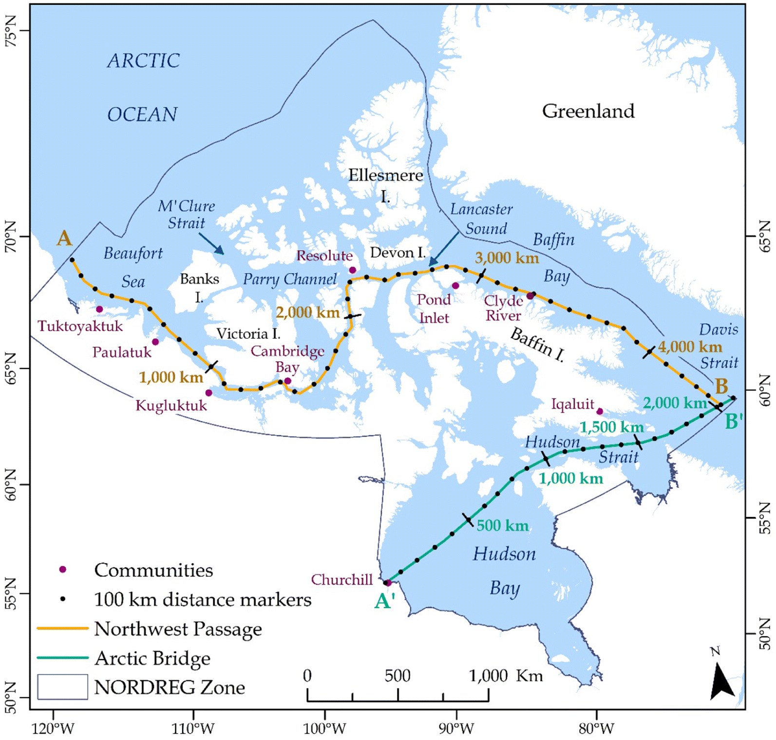
Table 1.
| AIRSS ship class | Maximum allowable ice type | Maximum allowable ice thickness (cm) |
|---|---|---|
| CAC 1 | No limit | No limit |
| CAC 2 | Multi-year | No limit |
| CAC 3 | Second-year | No limit |
| CAC 4 | Thick first-year | >120 |
| Type A | Medium first-year | 70–120 |
| Type B | Thin first-year (stage 2) | 50–70 |
| Type C | Thin first-year (stage 1) | 30–50 |
| Type D | Grey–white | 15–30 |
| Type E | Open water/Grey | 10–15 |
Note
CAC, Canadian Arctic Category.
The Arctic Shipping Safety and Pollution Prevention Regulations were updated in 2017 to include the Polar Code, which encouraged (and in some cases mandated) vessel operators to use the Polar Operational Limit Assessment Risk Indexing System to assess their navigability through Arctic waters (Justice Laws 2020). Our period of analysis for this study therefore stretches from the year of first ice chart availability in 1972, to one of the last years that AIRSS was mandated as a primary method of quantifying vessel navigability in the Canadian Arctic in 2016.
2.1. Ice chart conversion process
Weekly regional sea ice charts for the Western Arctic, Eastern Arctic, and Hudson Bay from 1972 to 2016 were downloaded from the Canadian Ice Service archive (canada.ca/en/environment-climate-change/services/ice-forecasts-observations/latest-conditions/archive-overview.html). The charts present information on sea ice conditions across regions with similar characteristics, with values presented in egg code format (see Canadian Ice Service 2016, for additional information about egg code interpretation). The charts include sea ice concentration in tenths, ice type, stage of development, and ice form information, essential for calculating the Ice Numeral (IN) values for shipping navigability. The IN refers to a number within AIRSS that determines whether a ship is permitted to navigate through a region. The system works by determining the Ice Multiplier (IM) for the ship type and each sea ice type within each region defined by a single egg code (Table 2), and multiplying this number by the concentration in tenths (C) of the sea ice type, to find the overall IN:
(1)
Table 2.
| Canadian Ice Service Ice Codes | Ice types/stages of development | Ice thickness (cm) | Type E | Type D | Type C | Type B | Type A | CAC 4 | CAC 3 |
|---|---|---|---|---|---|---|---|---|---|
| 7 • or 9 • | Old/multi-year ice | — | −4 | −4 | −4 | −4 | −4 | −3 | −1 |
| 8 • | Second-year ice | — | −4 | −4 | −4 | −4 | −3 | −2 | 1 |
| 6 • or 4 • | Thick first-year | >120 | −3 | −3 | −3 | −2 | −1 | 1 | 2 |
| 1 • | Medium first-year ice | 70–120 | −2 | −2 | −2 | −1 | 1 | 2 | 2 |
| 7 | Thin first-year ice | 30–70 | −1 | −1 | −1 | 1 | 2 | 2 | 2 |
| 9 | Thin first-year ice – 2nd stage | 50–70 | −1 | −1 | −1 | 1 | 2 | 2 | 2 |
| 8 | Thin first-year ice – 1st stage | 30–50 | −1 | −1 | 1 | 1 | 2 | 2 | 2 |
| 3 or 5 | Grey–white ice | 15–30 | −1 | 1 | 1 | 1 | 2 | 2 | 2 |
| 4 | Grey ice | 10–15 | 1 | 2 | 2 | 2 | 2 | 2 | 2 |
| 2 | Nilas, ice rind | <10 | 2 | 2 | 2 | 2 | 2 | 2 | 2 |
| 1 | New ice | <10 | 2 | 2 | 2 | 2 | 2 | 2 | 2 |
| Brash (ice fragments < 2m) | — | 2 | 2 | 2 | 2 | 2 | 2 | 2 | |
| = Δ | Bergy water | — | 2 | 2 | 2 | 2 | 2 | 2 | 2 |
| ¦¦¦ | Open water | — | 2 | 2 | 2 | 2 | 2 | 2 | 2 |
Note
Note that Canadian Arctic Category (CAC) 1 and CAC 2 are excluded from this table as they are designed to navigate through all sea ice types. Modified from Transport Canada (1998).
The terms on the right side of eq. (1) (subscript a, b, etc.) are repeated as many times as necessary to include all ice types within a region, including open water, to make up a total of ten tenths. This gives a maximum IN value of +20 for the most navigable conditions with ten tenths open water, and −40 for the least navigable conditions with ten tenths ice cover (ten tenths second-year or multi-year ice for weaker vessels; Table 2). When the IN is 0 or above the conditions are safe for the ship to proceed, and if the IN is negative, the conditions are considered too risky and the ship may not proceed. IN values are not determined for CAC 1 or CAC 2 ships in the AIRSS system as these are considered to have unrestricted navigation in all ice conditions in the Canadian Arctic (Transport Canada 1998). IM values can be increased by a value of 1 for decayed ice or decreased by a value of 1 for ridged ice, but these modifications were not considered as this information was not consistently available for all ice charts. Further detailed methodology for conversion of Canadian Ice Service ice charts to AIRSS shipping navigability charts is provided in section 3 of Transport Canada (1998) (tc.canada.ca/en/marine-transportation/marine-safety/arctic-ice-regime-shipping-system-airss).
Using eq. (1), shipping navigability maps were produced from each ice chart for each AIRSS vessel class. These vector maps were then converted into 12.5 km × 12.5 km rasters in ArcMap 10.2.2 to create a continuous spatial grid for analysis. To provide a measure of changes in navigability over time for a range of representative ship types, while keeping the number of navigability maps to a reasonable number, results are focused on changes for a highly strengthened ship class (CAC 3), a medium strengthened ship class (Type B), and for the least strengthened ship class (Type E). An example of a CAC 3 vessel is a strengthened bulk carrier or research vessel that can operate throughout the year in second and heavy first-year ice, and could proceed in multi-year ice if it is unavoidable (Transport Canada 1998) (Table 1). An example of a Type B ship is a general cargo community resupply vessel, which can operate in first year ice up to 70 cm thick. An example of a Type E ship is a pleasure craft with little to no ice strengthening, which can only operate in new grey ice <15 cm thick. In relation to the new Polar Code ice classes, a CAC 3 ship is considered to be equivalent to ice class PC 3, Type B is equivalent to ice class PC 7, and Type E is equivalent to ice class 1B (Justice Laws 2020).
Changes are assessed from the average of 5-year periods to remove the influence of inter-annual variability, for 1972–1976, 1992–1996, and 2012–2016. This covers the period from when ice charts are first consistently available for the entire shipping season, to the last year that AIRSS was used as the primary method of determining ice navigability, while providing regular sampling of conditions over the past five decades. For each period of analysis, changes in navigability are computed for early-season (25 June), mid-season (3 September) and late-season (15 October) conditions. The week of 25 June is the first time that weekly ice charts are consistently available for our entire study region, and this reflects a time when many ships are first entering the Arctic; 3 September is a period when sea ice conditions are near their annual minimum and ship movements are near their annual maximum; 15 October is the last time that weekly ice charts are regularly produced for the Canadian Arctic and is a period when vessel voyages are reducing towards their winter minimum. Analyses were focused on two main regions:
a.
The southern route of the Northwest Passage, stretching for ∼4500 km from the western Beaufort Sea, through the Canadian Arctic Archipelago, to southern Baffin Island (A to B; Fig. 1).
b.
The Canadian portion of the Arctic Bridge, stretching for ∼2100 km across Hudson Bay and Hudson Strait, to southern Baffin Island (A′ to B′; Fig. 1).
3. Results
3.1. Changes for CAC 3 vessels (highly ice strengthened)
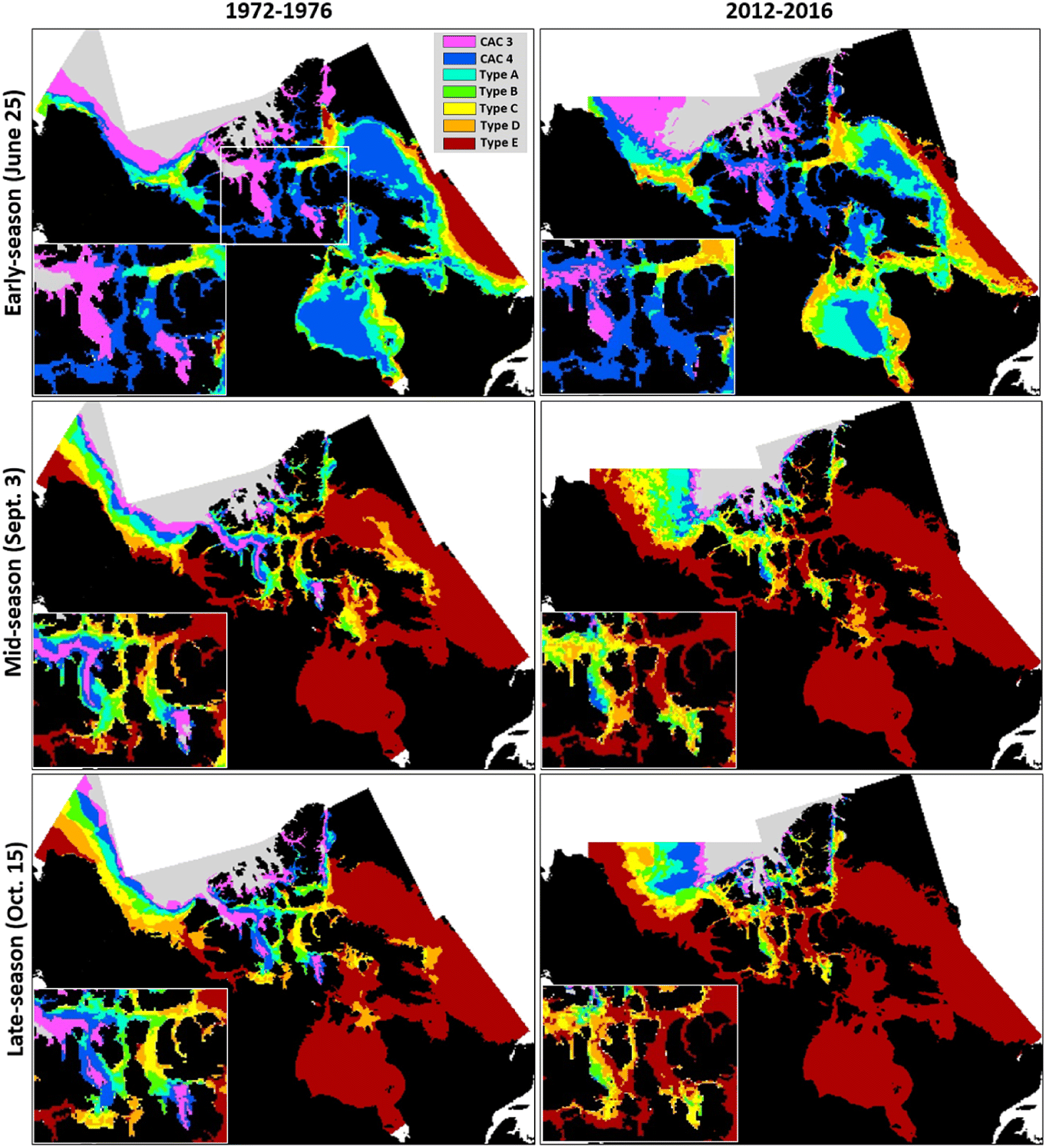
For highly ice-strengthened CAC 3 ships, there was little change in navigability over time for most shipping regions (Figs. 2–4). This vessel type was always able to access more southerly areas during the shipping season from the 1970s to present day, including Baffin Bay, southern Northwest Passage, Hudson Bay, and Hudson Strait. Areas to the north of the study area, such as the interior channels of the Queen Elizabeth Islands, were non-navigable for all periods. However, access did change significantly through the southern part of the Queen Elizabeth Islands, particularly along Parry Channel and M’Clure Strait, which were non-navigable or only partially navigable in all seasons in 1972–1976 and 1992–1996, but were easily navigable in all seasons in 2012–2016 (Fig. 2). This means that the northern route of the Northwest Passage has become a viable route for CAC 3 vessels in recent years for the first time.
Fig. 2.
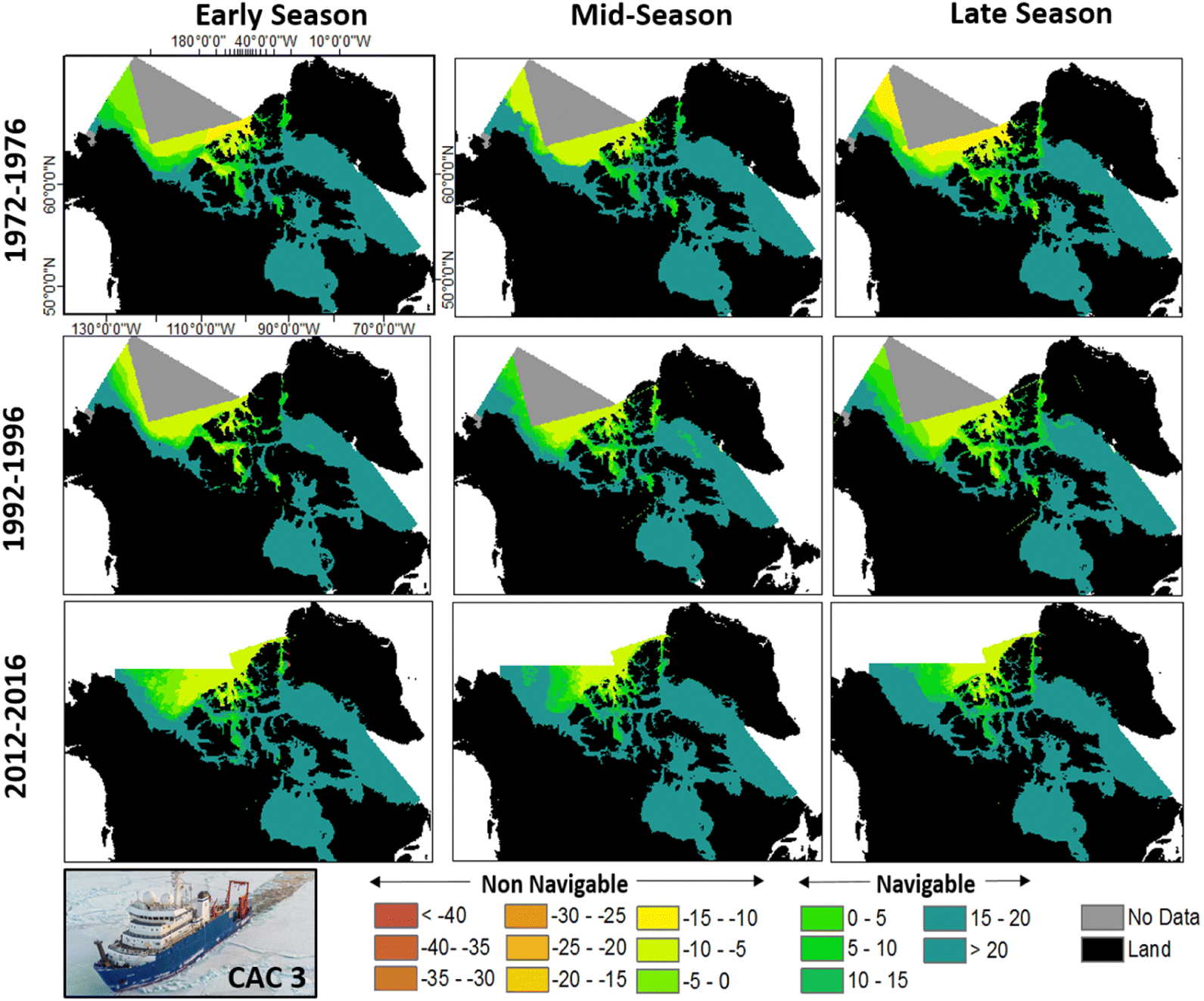
Fig. 3.
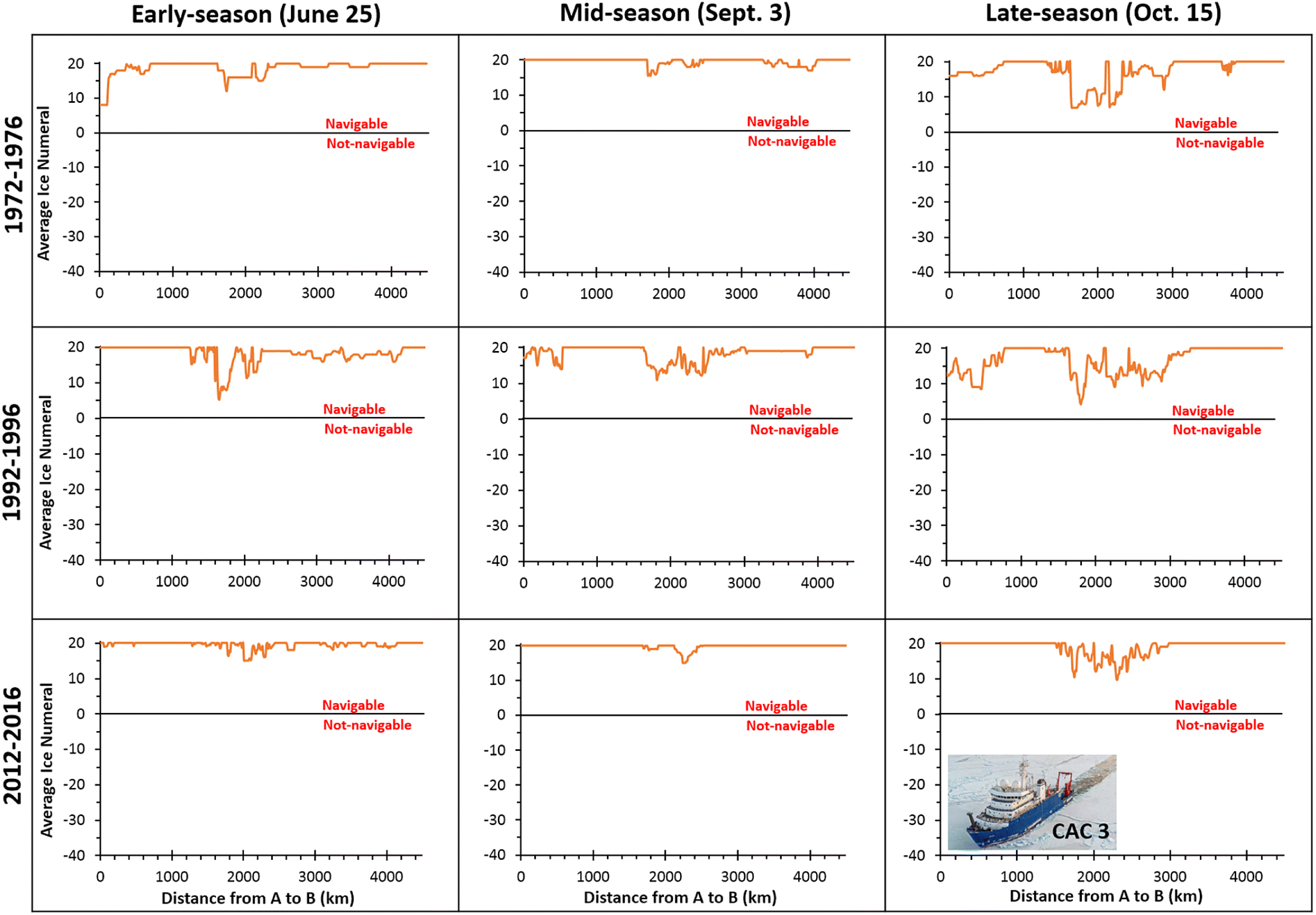
Fig. 4.
For the main southerly route of the Northwest Passage, plotted in Fig. 3, the only location where sea ice conditions provided some restrictions to navigability occurred between approximately Cambridge Bay and Pond Inlet (km1500 to km2800; see Fig. 1 for location of distance markers), as IN values dropped to as low as ∼5 in early season and late season in the 1970s and 1990s. For the Northwest Passage as a whole, mean IN values reached their lowest point in 1992–1996 with an overall mean for all seasons of 17.8, compared to an overall mean of 17.5 in 1972–1976 and 19.4 in 2012–2016 (where 20.0 indicates completely unimpeded travel; Table 3a). However, ships were permitted to proceed 100% of the distance across the Northwest Passage and Arctic Bridge in all periods and seasons as the IN values always remained positive (Table 4).
Table 3.
| (a) Northwest Passage | Canadian Arctic Category 3 (highly ice strengthened) | Type B (medium ice strengthened) | Type E (little ice strengthened) | ||||||
|---|---|---|---|---|---|---|---|---|---|
| Period | Early | Mid | Late | Early | Mid | Late | Early | Mid | Late |
| 1972–1976 | 18.7 | 19.5 | 17.4 | −8.4 | 15.2 | 13.2 | −15.6 | 14.2 | 10.7 |
| 1992–1996 | 18.2 | 18.4 | 16.7 | −8.4 | 14.7 | 11.2 | −14.8 | 14.3 | 8.0 |
| 2012–2016 | 19.5 | 19.8 | 18.9 | −3.0 | 18.7 | 17.4 | −9.3 | 18.6 | 16.4 |
| (b) Arctic Bridge | Canadian Arctic Category 3 (highly ice strengthened) | Type B (medium ice strengthened) | Type E (little ice strengthened) | ||||||
|---|---|---|---|---|---|---|---|---|---|
| Period | Early | Mid | Late | Early | Mid | Late | Early | Mid | Late |
| 1972–1976 | 19.9 | 20.0 | 20.0 | −4.9 | 20.0 | 19.7 | −11.0 | 20.0 | 19.7 |
| 1992–1996 | 19.8 | 20.0 | 20.0 | −1.4 | 20.0 | 20.0 | −6.8 | 20.0 | 20.0 |
| 2012–2016 | 19.9 | 20.0 | 20.0 | 4.5 | 20.0 | 20.0 | 0.4 | 20.0 | 20.0 |
Note
Higher values indicate easier navigability; a value of 20.0 is the maximum possible.
Table 4.
| (a) NW Passage | Canadian Arctic Category 3 (highly ice strengthened) | Type B (medium ice strengthened) | Type E (little ice strengthened) | ||||||
|---|---|---|---|---|---|---|---|---|---|
| Period | Early | Mid | Late | Early | Mid | Late | Early | Mid | Late |
| 1972–1976 | 100.0 | 100.0 | 100.0 | 27.1 | 94.3 | 85.9 | 22.7 | 88.3 | 80.6 |
| 1992–1996 | 100.0 | 100.0 | 100.0 | 24.2 | 90.6 | 84.5 | 14.4 | 89.0 | 67.9 |
| 2012–2016 | 100.0 | 100.0 | 100.0 | 42.2 | 100.0 | 98.9 | 37.6 | 100.0 | 95.9 |
| (b) Arctic Bridge | Canadian Arctic Category 3 (highly ice strengthened) | Type B (medium ice strengthened) | Type E (little ice strengthened) | ||||||
|---|---|---|---|---|---|---|---|---|---|
| Period | Early | Mid | Late | Early | Mid | Late | Early | Mid | Late |
| 1972–1976 | 100.0 | 100.0 | 100.0 | 23.7 | 100.0 | 100.0 | 15.0 | 100.0 | 100.0 |
| 1992–1996 | 100.0 | 100.0 | 100.0 | 40.2 | 100.0 | 100.0 | 22.6 | 100.0 | 100.0 |
| 2012–2016 | 100.0 | 100.0 | 100.0 | 65.8 | 100.0 | 100.0 | 46.4 | 100.0 | 100.0 |
3.2. Changes for Type B vessels (medium ice strengthened)
For ships with medium ice strengthening (Type B), there are large regions where these ships were unable to navigate in the early season (late June), from the 1970s to present day (Figs. 5–7). This encompasses most of Baffin Bay, Hudson Bay, Hudson Strait, the southern and northern routes of the Northwest Passage, and all the interior channels of the Queen Elizabeth Islands. However, the severity of the ice conditions still eased through time in the early season, particularly for 2012–2016 when compared to both 1972–1976 and 1992–1996. For the southern route of the Northwest Passage, for example, the mean IN for early-season conditions was −8.4 in both 1972–1976 and 1992–1996, compared to −3.0 in 2012–2016 (Table 3a). This relates to 27.1% and 24.2% of the Northwest Passage being navigable during this season in 1972–1976 and 1992–1996, respectively, compared to 42.2% of it being navigable in 2012–2016 (Table 4a). Early-season conditions for the Arctic Bridge route across Hudson Bay and Hudson Strait changed more dramatically over time, with a mean positive IN for the first time in 2012–2016 (Table 3b), and 65.8% of the route navigable in 2012–2016 compared to 40.2% in 1992–1996 and 23.7% in 1972–1976 (Table 4b). This represents a near tripling of areas navigable across the ∼2100-km long route, from ∼498 km in 1972–1976 to ∼1382 km in 2012–2016.
Fig. 5.
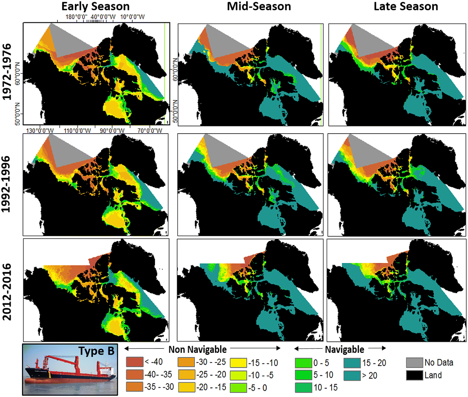
Fig. 6.
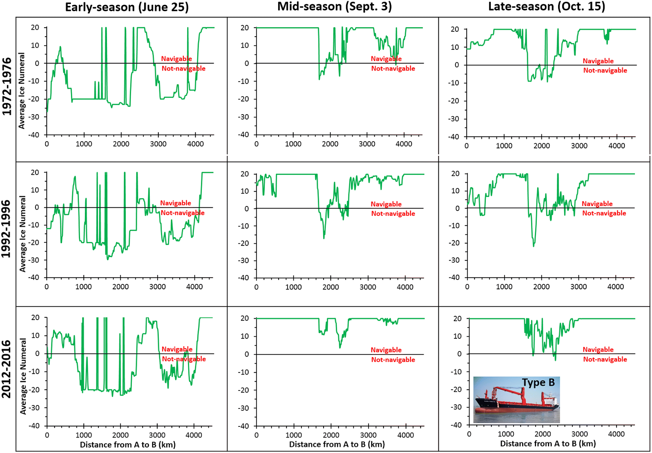
Fig. 7.
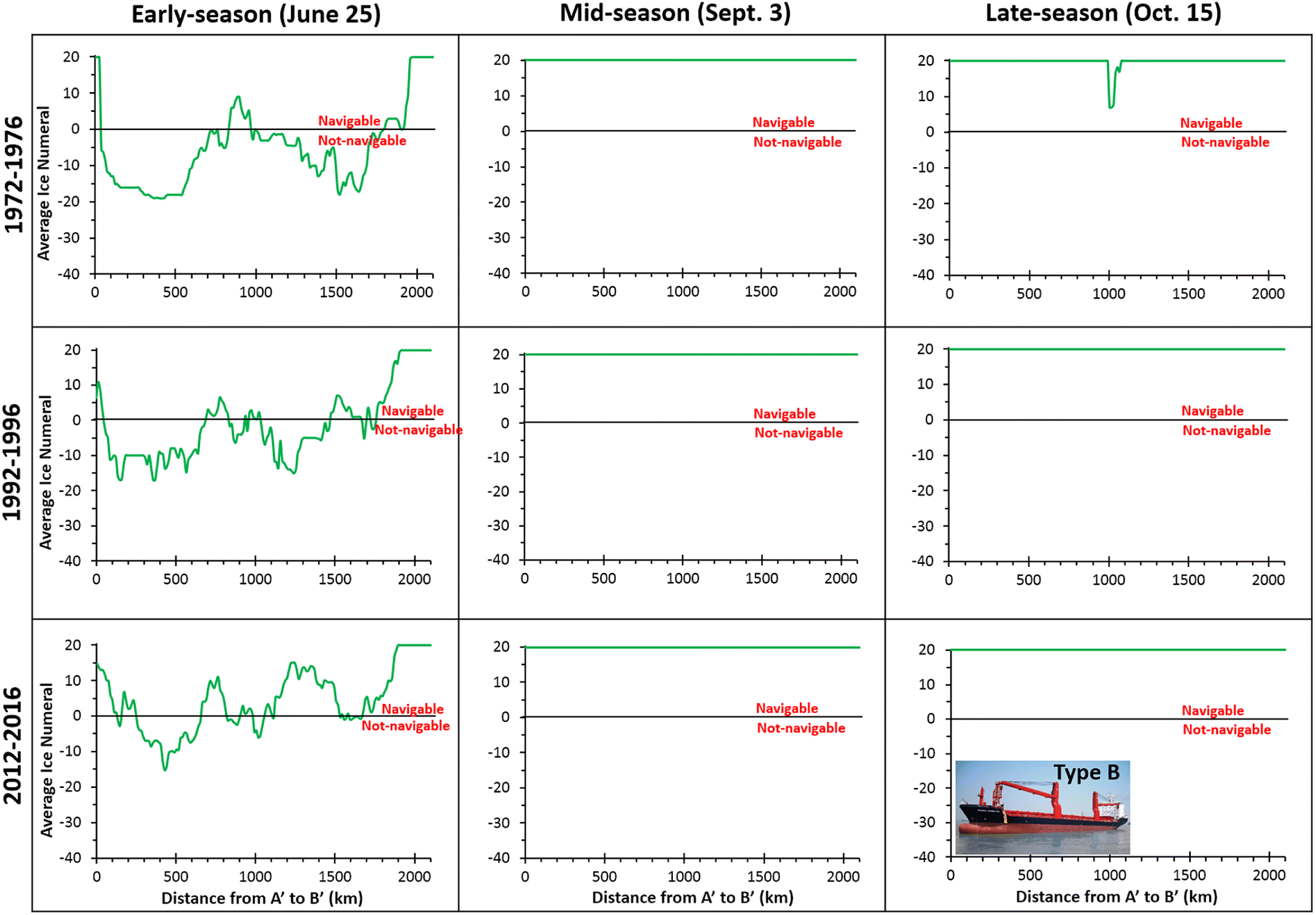
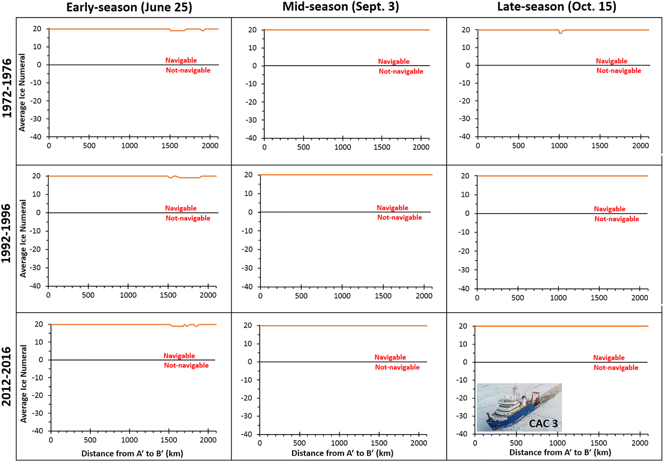
The accessibility for Type B vessels has become much easier recently for mid-season (early September) conditions across the southern route of the Northwest Passage, with ships being able to traverse this entire route during 2012–2016 (Fig. 6). In comparison, this ship type would not have been able to pass through this entire route in 1972–1976 or 1992–1996. At those times ∼5%–10% of its length was non-navigable, with the most challenging conditions centered around distance markers km1600 to km2400 to the west and north of Somerset Island (Table 4a; Figs. 5 and 6). This is reflected in the average IN for the Northwest Passage changing from 15.2 in 1972–1976, to 14.7 in 1992–1996, and 18.7 in 2012–2016 (Table 3a). For the Arctic Bridge route, and Hudson Bay and Hudson Strait in general, there were no changes in navigability over the study period as CAC 3 vessels were able to traverse these regions unimpeded for all periods (Fig. 7), with average IN values of 20.0 for all years (Table 3b).
For late-season (mid-October) conditions the Northwest Passage was almost completely passable during 2012–2016 for Type B vessels, with just a small area of negative IN values near Somerset Island, compared to large areas of this region being non-navigable in 1972–1976 and 1992–1996 (Fig. 6). Conditions were actually a little more severe in the 1990s than the 1970s, with a mean IN value of 11.2 in 1992–1996 (15.5% of the route non-navigable; 698 km), compared to 13.2 in 1972–1976 (14.1% of the route non-navigable; 635 km) (Tables 3a, 4a). In contrast, the mean IN value was 17.4 in 2012–2016, with only 1.1% (50 km) of the Northwest Passage non-navigable at that time. Across the Arctic Bridge route there were very few changes over time; there was a small area with slightly restricted navigability around distance marker km1000 in 1972–1976, but IN values were always highly positive, meaning that ships were able to navigate this entire region without restriction (Figs. 5 and 7), and mean IN values were at or near 20.0 (Table 3b).
3.3. Changes for Type E vessels (little ice strengthened)
For vessels with little ice strengthening (Type E), such as pleasure craft, they have never been able to pass through the entire southern Northwest Passage route in the early season (Figs. 8 and 9). Conditions have always been severe at that time of year, with INs of <−30 in some locations, although conditions have eased towards present day with a mean IN value for the route as a whole of −15.6 in 1972–1976, −14.8 in 1992–1996, and −9.3 in 2012–2016 (Table 3a). This equates to 22.7% (1022 km), 14.4% (648 km), and 37.6% (1692 km) of the route being navigable in these periods, respectively (Table 4a). Changes in navigability for the Arctic Bridge route were similar, with Type E ships never able to pass through the entire route in the early season for any period. However, conditions there have significantly eased towards the present day, with the mean IN being positive for the first time in 2012–2016 (Table 3b). Only 15.0% (315 km) of the Arctic Bridge route was navigable in the early season in 1972–1976, increasing to 22.6% in 1992–1996 (475 km) and 46.4% (974 km) in 2012–2016 (Table 4b).
Fig. 8.
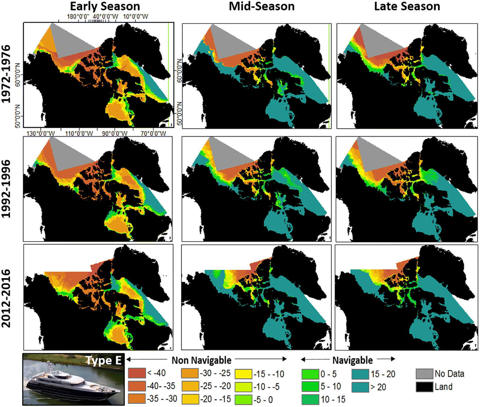
Fig. 9.
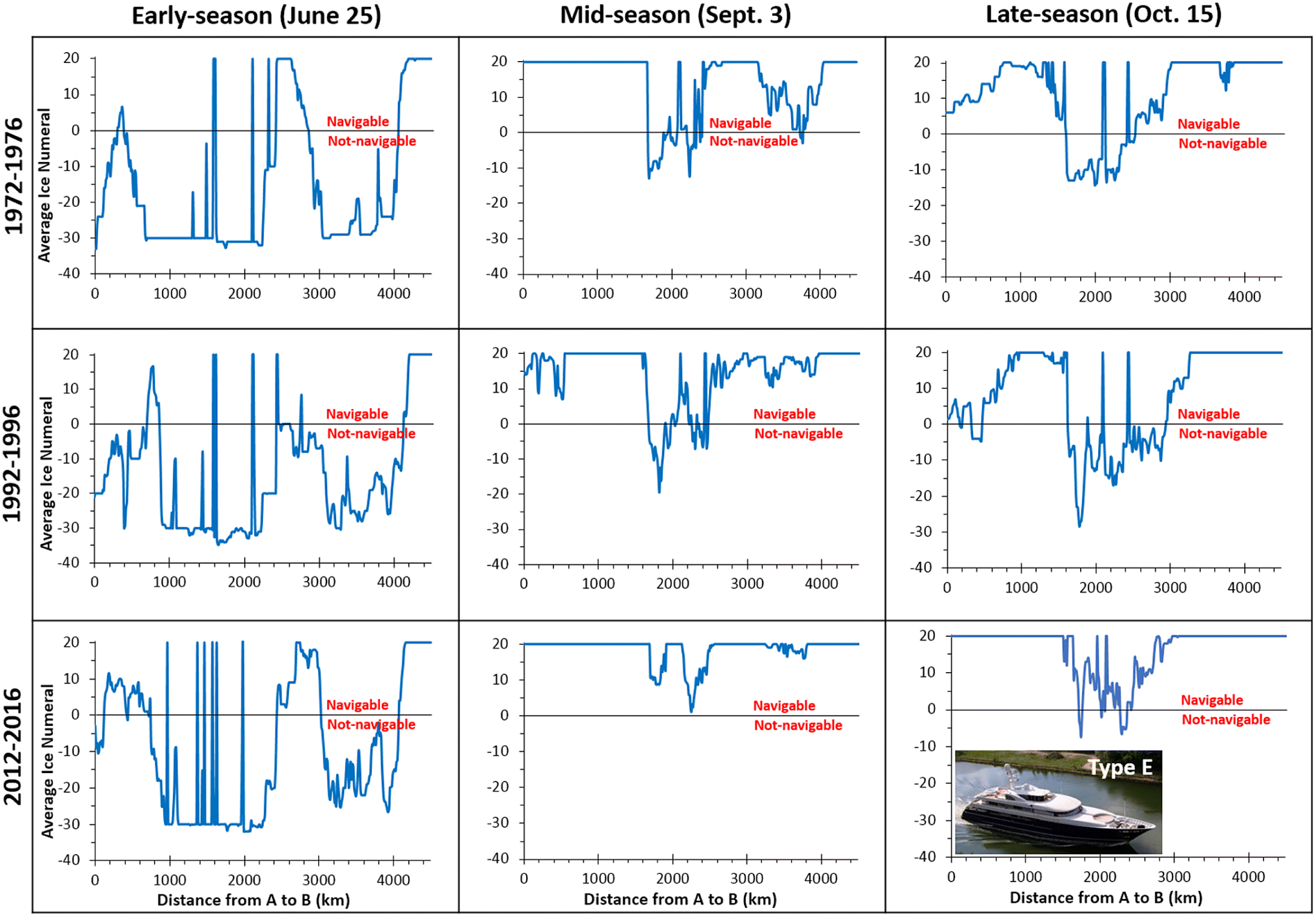
In the mid-season (early September), navigability through the entire southern route of the Northwest Passage for Type E vessels became possible for the first time in 2012–2016 (Fig. 9). This is a significant change from earlier periods, when 11.7% (527 km) of the route was non-navigable in 1972–1976, and 11.0% (495 km) was non-navigable in 1992–1996 (Table 4a). Vessels of this type were also able to travel unimpeded throughout Baffin Bay for the first time in 2012–2016, although access to the interior channels of the Queen Elizabeth Islands still was not possible in this timeframe (Fig. 8). For the Arctic Bridge route across Hudson Strait and Hudson Bay there were no restrictions to vessel movements at any time, with IN values of 20.0 (Fig. 10, Table 3b) and navigability of 100% for all three periods, 1972–1976, 1992–1996, and 2012–2016 (Table 4b).
Fig. 10.
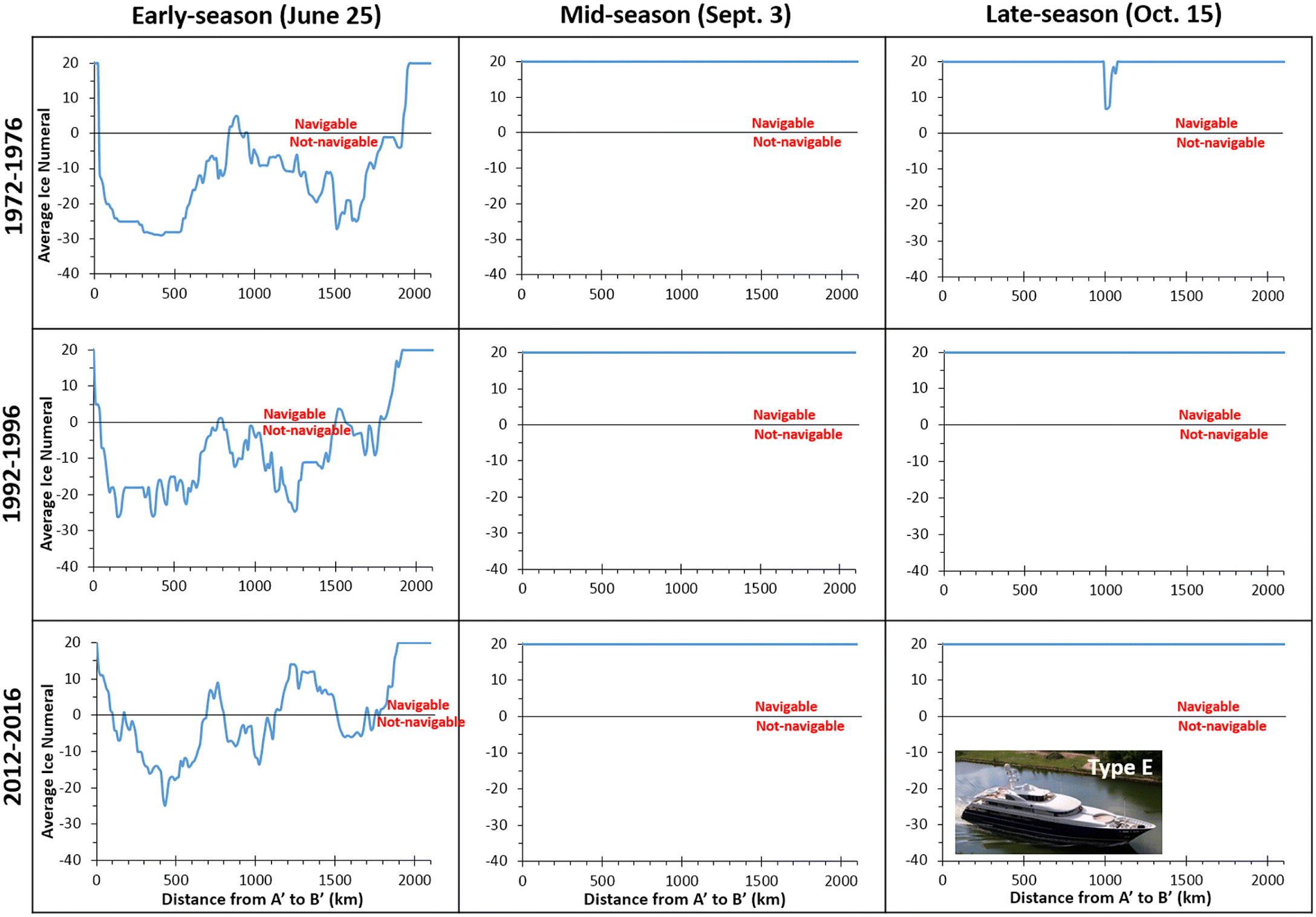
For late-season conditions, Type E vessels have been unable to navigate the entire Northwest Passage for any time period (Fig. 9), with the most restrictive region occurring between approximately km1500 (Cambridge Bay) and km2800 (Pond Inlet), similar to the patterns seen for other vessel types such as CAC 3. However, mean conditions have still eased over time, with mean IN values of 10.7 in 1972–1976, 8.0 in 1992–1996, and 16.4 in 2012–2016 (Table 3a). This is reflected in significant changes in the proportion of the Northwest Passage being navigable, from 80.6% (3627 km) in 1972–1976, down to 67.9% (3056 km) in 1992–1996, and a high of 95.9% (4316 km) in 2012–2016 (Table 4a). Across the Arctic Bridge route there was no significant change in navigability over time, with IN values near 20.0 (Table 3b) and 100% of the route navigable for all three time periods (Table 4b).
4. Discussion
From the results it is clear that it is becoming easier for ships to navigate across the Canadian Arctic. This is particularly true for the most recent period, 2012–2016, for vessels with medium (Type B) and little (Type E) ice strengthening that are travelling during the mid-season (early September) in more northern parts of the study area. Indeed, the only time when these vessels have been able to safely transit the entire length of the southern Northwest Passage was the mid-season in 2012–2016. Parts of this route have had IN values of <0 in all other seasons and all other periods, making complete transits impossible until the past decade (Figs. 6 and 9).
There are still significant hindrances to navigation for all vessel types in the early season (late June), although conditions are easing towards the present day. Late-season (mid-October) navigability is easier overall than that in the early season, and is also easing towards the present day, although negative INs still existed for parts of the Northwest Passage for Type B and Type E ships over the period 2012–2016.
The focus of this paper has been on vessel classes CAC 3, Type B, and Type E, but the changes apply to all vessel classes. This is well illustrated by plotting the weakest ship class able to access different regions of the study area for different parts of the shipping season in 1972–1976 vs. 2012–2016 (Fig. 11). This shows that the weakest class, Type E, has been able to access almost all areas of Hudson Bay in the mid-season and late season in 1972–1976 and 2012–2016. However, Hudson Bay has become much more accessible in the early season in the recent past, with Type A and Type B ships able to access most of it in 2012–2016 (e.g., to Churchill), compared to navigation being restricted to mainly CAC 4 vessels in 1972–1976. Essentially all of Baffin Bay has been accessible to Type E ships in the mid-season and late season in 2012–2016, but significant areas along the east coast of Baffin Island were only accessible to Type C or Type D ships in these seasons in 1972–1976. In the central portion of the Northwest Passage, highlighted in the inset panels in Fig. 11, there have been some of the largest changes over time; in the mid-season and late season only Type B or C vessels were able to access this region in 1972–1976, whereas Type E vessels were able to access most of it in 2012–2016. Finally, there has been a marked reduction in the strength of vessels able to access the southern part of the Beaufort Sea over time, with the range of all ship classes being pushed northwards, and Type E vessels being able to access the entire northern coastline of the Northwest Territories in the mid-season in 2012–2016, compared to only Type B vessels being able to access this entire coastline in 1972–1916.
Fig. 11.
Despite the easing of navigational conditions towards the present day, the narrow time window and limited region over which Type E vessels with little ice strengthening can safely operate in the southern route of the Northwest Passage means that significant risks still exist for their operation. The large variability in sea ice conditions that occur from year to year, even in recent years, means that they can still experience navigational hazards and get stuck (Washington Post 2017), with the Canadian Coast Guard reporting at least 20 Arctic-based search and rescues in 2018 (Coast Guard 2018). The area to the west and north of Somerset Island is highlighted as a significant region of difficult ice navigability, partly because this region has experienced some of the greatest recent increases in sea ice mobility due to the dynamic import of multi-year ice that is breaking up in the Arctic Ocean and transiting southward and into the Northwest Passages (Howell et al. 2013).
In terms of understanding the causes of changes in shipping navigability, reductions in the age, thickness, and area of sea ice across the study area directly relate to the ice types and coverage values used in the AIRSS calculations (Table 2, eq. (1)). To provide an indication of how these are changing on a regional basis, plotting of the minimum annual ice coverage was undertaken using data from the Canadian Ice Service IceGraphJ Tool (iceweb1.cis.ec.gc.ca/IceGraphJ/) for the Eastern Arctic, for the period 11 June to 15 October annually (to match our period of AIRSS navigability analysis). This shows that there have been significant reductions in total sea ice concentration over time at an average rate of 2.8% decade−1 over the period 1972–2016 (r2 = 0.361; p < 0.01; Fig. 12), as well as significant reductions in both first year ice (1.6% decade−1; r2 = 0.233; p < 0.01) and old ice (0.9% decade−1; r2 = 0.165; p < 0.01). Over our periods of interest, mean minimum ice area coverage for 1972–1976 was 18.7% (of which 7.7% was old ice), for 1992–1996 it was 19.3% (11.8% old ice), and for 2012–2016 it was 10.2% (6.0% old ice). These changes reflect the changes in navigability outlined above, with conditions not changing much between the 1970s and 1990s, but conditions significantly easing over the past decade as the ice cover has become younger and less extensive.
Fig. 12.

5. Conclusions
Analysis of ice navigability patterns across the Canadian Arctic indicates that it is becoming generally easier for all ship types to navigate this region up to the present day. In particular, there are many regions where the least ice-strengthened ships, such as Type E pleasure craft, were previously unable to navigate in the 1970s–1990s. For example, there were few periods when pleasure craft (Type E vessels) were able to transit through the southern route of the Northwest Passage until the 2000s, whereas recently >20 pleasure craft per year transit this part of the Arctic (Dawson et al. 2016; Johnston et al. 2017). Navigability conditions for cargo resupply (Type B) vessels are also easing, which helps to explain why vessels from eastern Canada have been able to resupply western Arctic communities by transiting through the NW Passage since ∼2000 (Dawson et al. 2016). However, sea ice conditions are still highly variable from one year to the next, meaning that a voyage through this region can quickly turn to disaster for poorly strengthened vessels with inexperienced crew, particularly for pleasure craft (Washington Post 2017).
Overall, navigability charts computed with the AIRSS system provide an effective method of determining the ease at which different vessel types have been able to move through Canadian Arctic waters. This provides insights into the controls on shipping movements, a way to provide risk assessment for ships operating in the Arctic, and an indication of the factors controlling changes in Canadian Arctic shipping.
Acknowledgements
We thank Transport Canada, Canadian Ice Service, Natural Sciences and Engineering Research Council of Canada, MEOPAR, Canada Foundation for Innovation, Ontario Research Fund, University of Ottawa, and ArcticNet, a Network of Centres of Excellence Canada, for funding. We are also grateful to the Canadian Ice Service for the provision of ice charts, and for comments from two anonymous reviewers which helped to improve the manuscript.
References
Canadian Ice Service. 2016. Interpreting ice charts. Chapter 1: the egg code [online]: Available from canada.ca/en/environment-climate-change/services/ice-forecasts-observations/publications/interpreting-charts/chapter-1.html.
Coast Guard. 2018. Canadian Coast Guard 2018 Arctic Operations coming to an end [online]: Available from canada.ca/en/canadian-coast-guard/news/2018/11/canadian-coast-guard-2018-arctic-operations-coming-to-an-end.html.
Copland L, Dawson J, and Cook A. 2019. Impacts of climate change on navigational choke points for ships operating in the Canadian Arctic. Report to Transport Canada Northern Transportation Adaptation Initiative, Ottawa, Ontario. 60 p.
Dawson J, Copland L, Johnston ME, Pizzolato L, Howell SE, Pelot R, et al. 2016. Adaptation strategies and policy options for Arctic shipping. A report prepared for Transport Canada, Ottawa, Ontario. 153 p.
Dawson J, Pizzolato L, Howell S, Copland L, and Johnston M. 2018. Temporal and spatial patterns of ship traffic in the Canadian Arctic from 1990 to 2015. Arctic, 71(1): 15–26.
Haas C, and Howell SEL. 2015. Ice thickness in the Northwest Passage. Geophysical Research Letters, 42: 7673–7680.
Howell SEL, Wohlleben T, Dabboor M, Derksen C, Komarov A, and Pizzolato L. 2013. Recent changes in the exchange of sea ice between the Arctic Ocean and the Canadian Arctic Archipelago. Journal of Geophysical Research: Oceans, 118(7): 3595–3607.
Johnston M, Dawson J, De Souza E, and Stewart EJ. 2017. Management challenges for the fastest growing marine shipping sector in Arctic Canada: pleasure crafts. Polar Record, 53(1): 67–78.
Justice Laws. 2020. Arctic Shipping Safety and Pollution Prevention Regulations SOR/2017-286 [online]: Available from laws-lois.justice.gc.ca/eng/regulations/SOR-2017-286/FullText.html.
Mudryk LR, Derksen C, Howell S, Laliberte F, Thackerey C, Sospedra-Alfonso R, et al. 2018. Canadian snow and sea ice: historical trends and projections. The Cryosphere, 12: 1157–1176.
Pizzolato L, Howell SEL, Dawson J, Laliberte F, and Copland L. 2016. The influence of declining sea ice on shipping activity in the Canadian Arctic. Geophysical Research Letters, 43: 12146–12154.
Transport Canada. 1998. User assistance package for the implementation of Canada’s Arctic Ice Regime Shipping System (AIRSS)—TP12819E—repealed [online]: Available from tc.canada.ca/en/marine-transportation/marine-safety/user-assistance-package-implementation-arctic-ice-regime-shipping-system-airss-1998-tp-12819-e-repealed.
Washington Post. 9 August 2017. Even small boats are tackling the fabled Northwest Passage. The ice doesn’t always cooperate [online]: Available from washingtonpost.com/news/energy-environment/wp/2017/08/09/we-wanted-to-be-early-northwest-passage-adventurers-held-back-by-lingering-ice/.
Information & Authors
Information
Published In
FACETS
Volume 6 • Number 1 • January 2021
Pages: 1069 - 1087
Editor: Irena Creed
History
Received: 27 October 2020
Accepted: 2 February 2021
Version of record online: 30 June 2021
Copyright
© 2021 Copland et al. This work is licensed under a Creative Commons Attribution 4.0 International License (CC BY 4.0), which permits unrestricted use, distribution, and reproduction in any medium, provided the original author(s) and source are credited.
Data Availability Statement
All relevant data are within the paper.
Key Words
Sections
Subjects
Authors
Author Contributions
LC, JD, and AT conceived and designed the study.
LC, AT, and FD performed the experiments/collected the data.
All analyzed and interpreted the data.
LC, JD, and AT contributed resources.
All drafted or revised the manuscript.
Competing Interests
The authors have declared that no competing interests exist.
Metrics & Citations
Metrics
Other Metrics
Citations
Cite As
Luke Copland, Jackie Dawson, Adrienne Tivy, Frances Delaney, and Alison Cook. 2021. Changes in shipping navigability in the Canadian Arctic between 1972 and 2016. FACETS.
6(): 1069-1087. https://doi.org/10.1139/facets-2020-0096
Export Citations
If you have the appropriate software installed, you can download article citation data to the citation manager of your choice. Simply select your manager software from the list below and click Download.
Cited by
1. Baseline levels and characterization of hydrocarbons in surface marine sediments along the transportation corridor in Hudson Bay: A multivariate analysis of n-alkanes, PAHs and biomarkers
2. Experimental Analysis of Survival and Recovery of Ship Fouling Mussels During Transit Between Marine and Freshwaters
3. Vessel risks to marine wildlife in the Tallurutiup Imanga National Marine Conservation Area and the eastern entrance to the Northwest Passage
4. Historical changes in the Davis Strait Baffin Bay surface winds and waves, 1979-2016