Canada’s human footprint reveals large intact areas juxtaposed against areas under immense anthropogenic pressure
Abstract
Efforts are underway in Canada to set aside terrestrial lands for conservation, thereby protecting them from anthropogenic pressures. Here we produce the first Canadian human footprint map by combining 12 different anthropogenic pressures and identifying intact and modified lands and ecosystems across the country. Our results showed strong spatial variation in pressures across the country, with just 18% of Canada experiencing measurable human pressure. However, some ecosystems are experiencing very high pressure, such as the Great Lakes Plains and Prairies national ecological areas that have over 75% and 56% of their areas, respectively, with a high human footprint. In contrast, the Arctic and Northern Mountains have less than 0.02% and 0.2%, respectively, of their extent under high human footprint. A validation of the final map, using random statistical sampling, resulted in a Cohen Kappa statistic of 0.91, signifying an “almost perfect” agreement between the human footprint and the validation data set. By increasing the number and accuracy of mapped pressures, our map demonstrates much more widespread pressures in Canada than were indicated by previous global mapping efforts, demonstrating the value in specific national data applications. Ecological areas with immense anthropogenic pressure highlight challenges that may arise when planning for ecologically representative protected areas.
Résumé
Des efforts sont en cours pour mettre de côté des portions terrestres du territoire canadien à des fins de conservation, les protégeant ainsi des pressions anthropiques. Ici, nous produisons la première carte de l’empreinte humaine canadienne en combinant 12 pressions anthropiques différentes et en identifiant les écosystèmes intacts et modifiés à travers le pays. Nos résultats démontrent une variation spatiale importante parmi les différentes pressions à travers le pays, avec seulement 18% du Canada enregistrant une pression humaine mesurable. Cependant, certains écosystèmes enregistrent une pression très élevée, comme les aires écologiques nationales des Plaines des Grands Lacs et des Prairies qui ont respectivement plus de 75% et 56% de leurs superficies sous forte empreinte humaine. Par ailleurs, l’Arctique et les Montagnes du Nord ont moins de 0.02% et 0.2% de leur superficie sous forte empreinte humaine. Une validation finale de la carte, à l’aide d’un échantillonnage statistique randomisé, révèle une valeur de 0.91 pour le coefficient Cohen Kappa, indiquant un accord « presque parfait » entre l’empreinte humaine et l’ensemble des données. En augmentant le nombre et la précision des pressions cartographiées, notre carte démontre des pressions beaucoup plus répandues au Canada telles qu’indiquées par les efforts précédents de cartographie globale, illustrant la valeur des applications spécifiques de données nationales. Les aires écologiques soumises à une immense pression anthropique mettent en évidence les défis qui émergent lors de la planification des aires protégées représentatives d’importance écologique.
Introduction
Global pressures to biodiversity are increasing as human use continues to alter terrestrial ecosystems (Steffen et al. 2015; Venter et al. 2016a), leading to accelerating biodiversity declines (Maxwell et al. 2016; Newbold et al. 2015). Anthropogenic pressures to biodiversity are actions taken by humans in the past, present, or future that have the potential to harm natural systems (Canter and Ross 2010; Venter et al. 2016a). Pressures on a landscape can interact with each other in a complex manner, such as cumulative, synergistic, or additive, and vary in their spatial and temporal scales, making their understanding essential for conservation planning (Geldmann et al. 2014; Halpern and Fujita 2013; Primack 1993; Tapia-Armijos et al. 2017). Identifying the patterns of change in these pressures provides a potential basis for preventing or mitigating anthropogenic disturbance (Halpern et al. 2015; Venter et al. 2016a).
When pressures are analysed, especially those from resource development projects, the focus is often on the project in isolation of other developments (Duinker and Greig 2006; Johnson 2016; Sinclair et al. 2017; Westwood et al. 2020). By incorporating more than one pressure, it is possible to develop a more complete understanding of the interacting pressures on biodiversity, with the potential to assess the impacts for ecosystem services (Halpern et al. 2008). Cumulative pressure mapping allows for the combination of more than one pressure to show the full extent and intensity of anthropogenic pressures (Tapia-Armijos et al. 2017). Cumulative pressure maps, also known as human footprint maps, combine pressures into a single product that can be used to yield the greatest conservation benefit, including directing development to areas that will cause the least amount of harm to the system (Crain et al. 2009; Venter et al. 2016a).
Canada’s natural systems have a number of pressures that negatively affect biodiversity. Woo-Durand et al. (2020) analysed pressures to 820 species identified as “at risk” by the Committee on the Status of Endangered Wildlife in Canada (COSEWIC). They found that the number of pressures affecting each species has increased significantly from an average of 2.5 to 3.5 between 1999 and 2018. Such findings highlight the need to map pressures in Canada cumulatively and not in isolation (Venter et al. 2006; Woo-Durand et al. 2020). Nevertheless, no cumulative pressure map covers the entirety of the country. At present, Canada has cumulative pressure maps for parts of the coastal waters (Ban and Alder 2008; Ban et al. 2010; Clarke Murray et al. 2015a, 2015b) and two studies covering freshwater (Robb 2014; Sterling et al. 2014). For terrestrial studies, the greatest coverage spans the largest ecological area of Canada, the Boreal/Taiga (Pasher et al. 2013). Other terrestrial maps cover sections of western Canada (Mann and Wright 2018; Shackelford et al. 2017), part of eastern Canada and the United States (Woolmer et al. 2008), and the whole of Canada to display the number of pollution pressure categories present (McCune et al. 2019). In addition to human footprint maps, a map exists showing the presence and absence of access into nature across Canada (Lee and Cheng 2014). However, a simple map of access does not fully represent the spectrum of human pressures, such as the contrast between large metropolitan cities and smaller resources centric towns (Lee and Cheng 2014), or landscapes under pressure from resource extraction. Global human footprint maps display Canada as mostly intact (Sanderson et al. 2002; Venter et al. 2016a, 2016b); however, that includes only a subset of pressures relevant to the country, missing critical data for the Canadian context such as mining and forestry, though more recent global updates have taken place (Jacobson et al. 2019). Therefore, until a national human footprint is produced, there will continue to be a gap in our understanding for the Canadian human footprint.
As a signatory of the Convention on Biodiversity and its Aichi Biodiversity Targets, Canada’s Target 1 is to protect 17% of terrestrial and 10% of marine areas (MacKinnon et al. 2015). With this ambitious conservation target there is a need to better understand the distribution of pressures to natural systems across Canada. A nationwide map of human pressures is important for identifying the ecosystems that are most intact and the areas with the greatest intensity of human pressures. Intactness is defined as landscapes that maintain biological and ecological function and are mostly free of nonindigenous human pressures. This definition does not exclude Indigenous Peoples and their stewardship practices, but it does exclude large-scale land conversion, human activity, and development (Waller and Reo 2018; Watson et al. 2016). Mapping the human footprint will serve as an important step in selecting which areas to protect, restore, and sustainably manage.
Here, we used geospatial techniques to develop a map for Canada that represents nationally specific pressures across our ecological areas that are not incorporated in coarse-scale global maps. Using a higher spatial resolution of 300 m, we produced the first national terrestrial human footprint of Canada. We visually and quantitatively compared the global and national products and identified improvements and errors in the representation of human pressures. We used high-resolution satellite imagery to validate the accuracy of the final footprint map. As the maintenance of biodiversity and ecosystem services depends on the comprehensive understanding of the full set of overlapping pressures (Sala et al. 2000), the results of this project will be important for identifying future conservation lands across Canada as well as ecosystems that are in need of protection and restoration.
Methods
Overview
To produce the Canadian human footprint, we adopted the methods originally developed by Sanderson et al. (2002) and later refined by Venter et al. (2016a, 2016b). The pressures we mapped for Canada were: the extent of built environments, crop land, pasture land, human population density, nighttime lights, railways, roads, navigable waterways, dams and associated reservoirs, mining activity, oil and gas, and forestry (Table 1). Each anthropogenic pressure was placed on a 0–10 scale to allow for comparison across pressures. Scoring methods were selected from pre-existing peer-reviewed articles following methods in Venter et al. (2016a, 2016b) and Woolmer et al. (2008) and the oil and gas pressure layer following methods used in Jarvis et al. (2010). After scoring, all noncompatible land uses were analysed and adjusted to avoid spatial overlap. Noncompatible land uses included built environments, crop land, mining, and pasture land. We eliminated any pixels from the given layers that overlapped with built environments, then we did the same operation for crop land and mining. To determine which layer would be kept if spatial overlap was present where it should not be, the layer with the highest score from the 0 to 10 scale was kept. To produce the final product of the terrestrial human footprint map of Canada, all the weighted layers were summed together. To compare different ecological areas in Canada, the COSEWIC national ecological areas were used (COSEWIC 2018). Individual pressures may overlap spatially and are therefore not mutually exclusive. Thus, each cell could range in value from 0 to 55 for any given grid cell, representing the observed maximum. The map was generated at a spatial resolution of 300 m, yielding over 99,000,000 pixels. We chose 300 m as a reasonable compromise between spatial precision and computational time, as well as the reference resolution of the land cover data we used. ArcGIS 10.5.1 and the Lambert Conformal Conic projection were used for all spatial analyses. Specific details on each of the pressure layers are provided in the following sections.
Table 1.
Note Supplementary Material, S4 shows the 12 pressures reclassified into the IUCN – CMP Unified Classification of Direct Threats.
Built environments
Built environments are lands that are constructed for human activity and include buildings, paved surfaces, and urban areas. Land transformation from built environments leads to habitat loss and fragmentation, changes in nutrient and hydrological flows, reduction of viable habitats for species, and decreased temperature regulation and carbon sequestration (Haase 2009; Tratalos et al. 2007).
We acquired data from the 2016 annual crop inventory (Government of Canada; Agriculture and Agri-Food Canada; Science and Technology Branch 2016), which provides a 30-m spatial resolution of land-use type and applied the subset of the “urban/developed” lands for the layer. The data do not include Yukon and Northwest and Nunavut territories; therefore, we captured the anthropogenic pressures for the northern territories through other layers such as: population density, nighttime lights, and roads. The data were a combination of satellite imagery: Landsat-8, Sentinel-2, and Gaofen-1 for optical imagery with RADARSAT-2 radar imagery, generating an accuracy of at least 85% (Government of Canada; Agriculture and Agri-Food Canada; Science and Technology Branch 2016). Built environments were assigned a score of 10 as built environments do not provide many ecosystem services or provide suitable habitat for many species of concern (Venter et al. 2016a, 2016b).
Population density
Human population density is linked to biodiversity loss (Cincotta and Engelman 2000). Presence of high human populations has led to over-hunting, deforestation, and introduced species (Prebble and Wilmshurst 2009). Though Canada generally has a low population density, (∼4 persons/km2) there have been significant increases in introduced species, over-exploitation, and pollution from 1999 to 2018 (Government of Canada; Statistics Canada 2017a; Woo-Durand et al. 2020).
Human population density was mapped using a subset of the 2016 Canadian Census Data (Government of Canada; Statistics Canada 2017a; Venter et al. 2016b). The vector layer used was the Census Dissemination Blocks, the smallest unit with an associated population, available through the Geo Suite 2016, a Statistics Canada tool we used for data retrieval (Government of Canada; Statistics Canada 2016). Following Venter et al. (2016a, 2016b), we calculated population density for each block; we assigned a pressure score of 10 for any block that had more than 1,000 people/km2, as the assumption is that population density becomes saturated at that level (Venter et al. 2016a, 2016b). For more sparsely populated areas, we logarithmically scaled the pressure score as seen below to mimic how pressures on the system increase with population density:
Nighttime lights
Nighttime lights capture the sparser electric infrastructure found in rural, suburban, and working areas that have an associated pressure on natural environments (Venter et al. 2016a, 2016b). The Visible Infrared Imaging Radiometer Suite (VIIRS), mounted on the Sumo National Polar Partnership satellite, provides the means to collect and map low-light sources such as nighttime lights (Elvidge et al. 2013).
We used an annual composite from 2016 generated by the National Oceanic and Atmospheric Administration (NOAA) to assess nighttime lights. The spatial resolution of the data is 589 m (15 arc-second geographic grids). For areas above 67°N, that were not included in the annual composite, we randomly selected a single date of imagery to fill the northern section and visually compared it with other dates to make sure it was not an outlier (NOAA 2019). We then rescaled the data on a 0–10 scale using an equal quintile approach (Venter et al. 2016a, 2016b).
Crop and pasture land
Agriculture is recognised as one of the most important pressures to biodiversity globally (Ricketts and Imhoff 2003). For the Canadian human footprint, we used the 2016 annual crop inventory that includes pasture, agricultural land, cereals, pulses, oil seeds, vegetables, fruits, and other crops (Government of Canada; Agriculture and Agri-Food Canada; Science and Technology Branch 2016). Satellite imagery from optical (Landsat-8, Sentinel-2 and Geifen-1) and radar (RADARSAT-2) was used to obtain a spatial resolution of 30 m. The provincial accuracy for crop class had a minimum of 86.27% and a maximum accuracy of 94.51% (Government of Canada; Agriculture and Agri-Food Canada; Science and Technology Branch 2016). We assigned crops a pressure score of 7, as some species can still use crop lands unlike most built environments (Venter et al. 2016a, 2016b).
Pasture lands are areas that are grazed by domesticated livestock. Pastures are often associated with fences, soil compaction, intensive browsing, invasive species, and altered fire regimes (Kauffman and Krueger 1984). Using the annual crop inventory (30-m spatial resolution) (Government of Canada; Agriculture and Agri-Food Canada; Science and Technology Branch 2016), we assigned pastures a pressure score of 4, as it is less intensive than crop lands; however, pasture lands are associated with fencing that would no longer allow for the land to be intact (Venter et al. 2016a, 2016b).
Roads and railways
Roads are linear features that directly convert and fragment habitats. Roads can alter the immediate physical and chemical environments, provide access for human recreation into intact areas, allow for the spread of invasive species, and be a sink for populations through vehicle collisions and mortality from construction (Trombulak and Frissell 2000).
We used the publicly available 2016 National Road Network vector layer produced by Statistics Canada (Government of Canada; Statistics Canada 2017b). The data are divided into different categories of use: Trans-Canada highway, national highway system, major highway, secondary highways, major streets, and all other streets. Following Woolmer et al. (2008) we assessed roads from the lens of access points into intact areas and gave different weights to linear road features and associated buffers based on road type (Table 2).
Table 2.
| Road Type | 0–300 m | 300–600 m | 600–900 m | 900–3,000 m |
|---|---|---|---|---|
| Trans-Canada highway | 10 | 8 | 6 | 4 |
| National highway and major highways | 8 | 6 | 4 | 2 |
| Secondary highways, major streets and all other streets | 6 | 4 | 2 | 0 |
Note The distances represent the scores associated with each of the buffers.
Railways provide a direct pressure to the ecosystems that host them; however, in terms of access they differ from roads. For roads and railways, direct pressures exist as a result of the actual footprint such as physical removal of viable habitat or reduction in the quality of it; indirect pressures may present themselves in the form of altering ecological functions, edge effect, reducing connectivity, or other human pressures made possible by the direct pressure (Burton et al. 2014). However, discontinued rail lines provide an indirect pressure as they can be used as a means of dispersal of humans and their activities into landscapes. Conversely, operational rails only allow for human access from individual rail stations. We used the publicly available National Railway Network vector layer (Government of Canada; Natural Resources Canada 2016) and adapted the methods from Woolmer et al. (2008) using operational and discontinued rails, going out a maximum distance of 900 m using the same intervals as roads (Table 3).
Table 3.
| Rail Type | 0–300 m | 300–600 m | 600–900 m |
|---|---|---|---|
| Operational | 6 | 4 | 0 |
| Discontinued | 6 | 4 | 1 |
Note The distances represent the scores associated with each of the buffers.
Navigable waterways
Navigable waterways like roads and rails act as means of access to wilderness areas. Canada’s waterways have a long history of human use as they have enabled travel from sea to sea (Brine 1995). Once the people’s “highway”, settlements were formed along the waterways to allow movement and access. Used by First Nations in precolonial times, the knowledge was shared when the first European explorers arrived. These waterways were later instrumental in the fur trade (Brine 1995; O’Donnell 1989).
We used the data set generated for navigable coasts for 2009 from the global human footprint with a 1 km2 spatial resolution (Venter et al. 2016b). The layer included the Great Lakes, as they can act like inland seas, and was generated using distance to settlements, stream depth, and hydrological data (Venter et al. 2016b). We found the centreline of the waterway then weighted them to follow the other access-based layers (Table 4).
Table 4.
| 0–300 m | 300–600 m | 600–900 m | |
|---|---|---|---|
| Navigable Waterways | 6 | 4 | 2 |
Note The distances represent the scores associated with each of the buffers.
Dams and reservoirs
Dams directly change hydrology of the areas and they modify the environment, often producing human-made flooded reservoirs (Woolmer et al. 2008). The vector data set was obtained from “Large Dams and Reservoirs of Canada” (Global Forest Watch Canada 2010). We mapped the physical dam as we would a built environment, scoring it as 10 (Venter et al. 2016a, 2016b; Woolmer et al. 2008). We scored the associated reservoirs in the same manner as navigable waterways given that they can provide additional access to areas by watercraft (Table 4).
Mining
Mining often alters topography and watercourses and removes topsoil as a form of land conversion. Mining can be a point source for air and water pollution (Woolmer et al. 2008). We used the mines and minerals data set, updated in 2015, to obtain all active mines in Canada. The data were discrete points in vector format (Government of Canada; Natural Resources Canada 2017). We placed the mineral groups in their designated categories: open large, open small, underground large, and underground small (WWF Canada 2003). For the minerals that were not previously classified by Woolmer et al. (2008) we consulted with an expert to determine if the mineral group would be mined underground or in an open pit (McGill, personal communication, 31 October 2018). Once confirmed to be open or underground, we placed them all in the small category, for open pit and underground mining, as a way to make sure we did not over-estimate the pressure. The scoring from Woolmer et al. (2008) was used for mines (Table 5).
Table 5.
| Mine Type | 0–600 m | 600–1,500 m | 1,500–2,400 m | 2,400–5,100 m | 5,100–10,000 m |
|---|---|---|---|---|---|
| Open pit (large) | 8 | 8 | 4 | 2 | 1 |
| Open pit (small) | 8 | 4 | 2 | 2 | 0 |
| Underground (large) | 6 | 6 | 4 | 2 | 1 |
| Underground (small) | 6 | 4 | 2 | 2 | 0 |
Note The distances represent the scores associated with each of the buffers.
Oil and gas
Oil and gas production have a number of associated pressures to nature such as wildlife mortality, habitat fragmentation and loss, noise and light pollution, introduction of invasive species, and sedimentation of waterways (Brittingham et al. 2014; Jones et al. 2015). The mines and minerals data set, updated in 2015, was used as it lists active oil and gas fields. The data were discrete points in vector format (Government of Canada; Natural Resources Canada 2017). The direct pressures from oil and gas have been found to be highly localized; therefore, we adapted the scoring method using a 10 to 0 scale to score the linear circular decay out to 5 km away from the site centre (Jarvis et al. 2010).
Forestry
Forestry operations alter the forest structure by changing stand dynamics and age (Freedman et al. 1994). Clear-cut forestry can remove habitat for species dependent on old trees, deadwood, and tree cavities and by altering paths of travel and allowing for deep snow to form. Forestry operations could also introduce species and allow for more access for recreation including hunting through the creation of forestry roads (Freedman et al. 1994). However, when forestry mimics local natural disturbance regimes of sustainable forest management practices, it could be ecologically appropriate (Armstrong 1999; Siry et al. 2005).
The forest-harvest data were obtained from an annual forest disturbance characterization project for Canada that has a 30-m spatial resolution (White et al. 2017). The time scale of the harvest recorded was from 1985 to 2015. We separated fresh clear cuts and areas that have reached their free-to-grow state, as they offer different habitat qualities (Bergeron et al. 2011). We selected 12 years as a common value for free-to-grow, so anything from 0 to 12 years would be considered early regenerating forest (Lieffers et al. 2002; Smith 1983). We adapted the scoring from Woolmer et al. (2008) with early regeneration scored as 4 and older regeneration as 2 (Woolmer et al. 2008).
Technical Validation
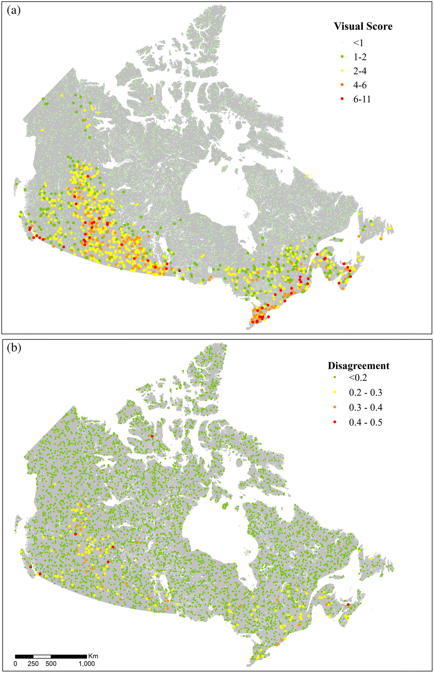
Following the methods used by Venter et al. (2016a, 2016b), a single independent person used high-resolution satellite imagery to visually identify human pressures within 5,000 randomly located, 1-km2 sample plots, after training and obtaining “almost perfect agreement” for 400 random plots between trainer and independent validator. Using World Imagery, available through ArcGIS, the 5,000 plots had a median resolution of 0.5 m and a median acquisition year of 2014 (ArcGIS. n.d.).
We used methods from Venter et al. (2016a, 2016b) to develop a standardized key to visually interpret the pressures. For the eight pressures that both our Canadian human footprint and the global human footprint had in common we mimicked their scoring, but for the new pressures included in our study we simply followed their standards for linear or polygons features (Supplementary Material, S1). Interpretations were marked if they were “certain” or “uncertain”; in our case 254 plots were uncertain and therefore discarded, leaving 4,746 validation plots. Generally, plots were classified as uncertain for two main reasons: inadequate resolution of the imagery (15 m) so it was not clear if there were any pressures present on the land or cloud cover obscuring some of or all the image. The plots that were retained for the visual scoring were all certain and we therefore consider the in-situ pressures for the plot as true. The mean human footprint score for the 1-km2 plots were determined in ArcGIS, then both the visual and human footprint scores were normalized on a 0–1 scale.
The root mean squared error (Chai and Draxler 2014) and the Cohen kappa statistic of agreement (Viera and Garrett 2005) were used to quantify the level of agreement between the Canadian footprint map and the validation data set. The root mean squared error measures the differences between the values calculated in the human footprint and the visual scores from the validation. As the error is squared, outliers are emphasized with this statistical calculation. The Cohen kappa statistic of agreement expresses the agreement between the human footprint scores and the visual interpretation scores considering the potential that agreement or disagreement may occur by chance. Following previous analyses (Venter et al. 2016a, 2016b), visual plots that were within 20% of the human footprint plots scores were considered a match for the Cohen kappa statistic.
Results
The Canadian human footprint
Canada has an area-weighted average human footprint score of 1.48, and the maximum observed score for the country is 55 out of a theoretical 66. The pressures across Canada display strong spatial patterns, showing higher values in Southern Canada where most of the country’s population lives (Fig. 1). With the 12 pressures included, we found that 82% of Canada’s land areas had a human footprint score of less than 1 and therefore were considered intact (Allan et al. 2017). In this context, intact is defined as landscapes that are mostly free of the 12 human pressures we mapped. To conceptualize this definition of intact, cells that had a population density of one or more people per square kilometre obtained a pressure score of 1 or above and were therefore not considered intact. However, pressures such as seismic lines, pollution, or invasive species were not mapped and may be present in areas that we identified as intact. The low human footprint state was defined as areas where the human footprint score was between 1 and 4. The upper limit was determined based on the assignment of a score of 4 for pasture land, which would often have fences fragmenting the connectedness (Venter et al. 2016a). Approximately 5% of Canada was classified in the low human footprint state. The moderate human footprint areas had scores between 4 and 10 and covered 7% of the country. The areas of high human footprint, with a value of 10 or higher, covered 6% of Canada and highlighted areas with multiple overlapping pressures to biodiversity (Fig. 1).
Fig. 1.
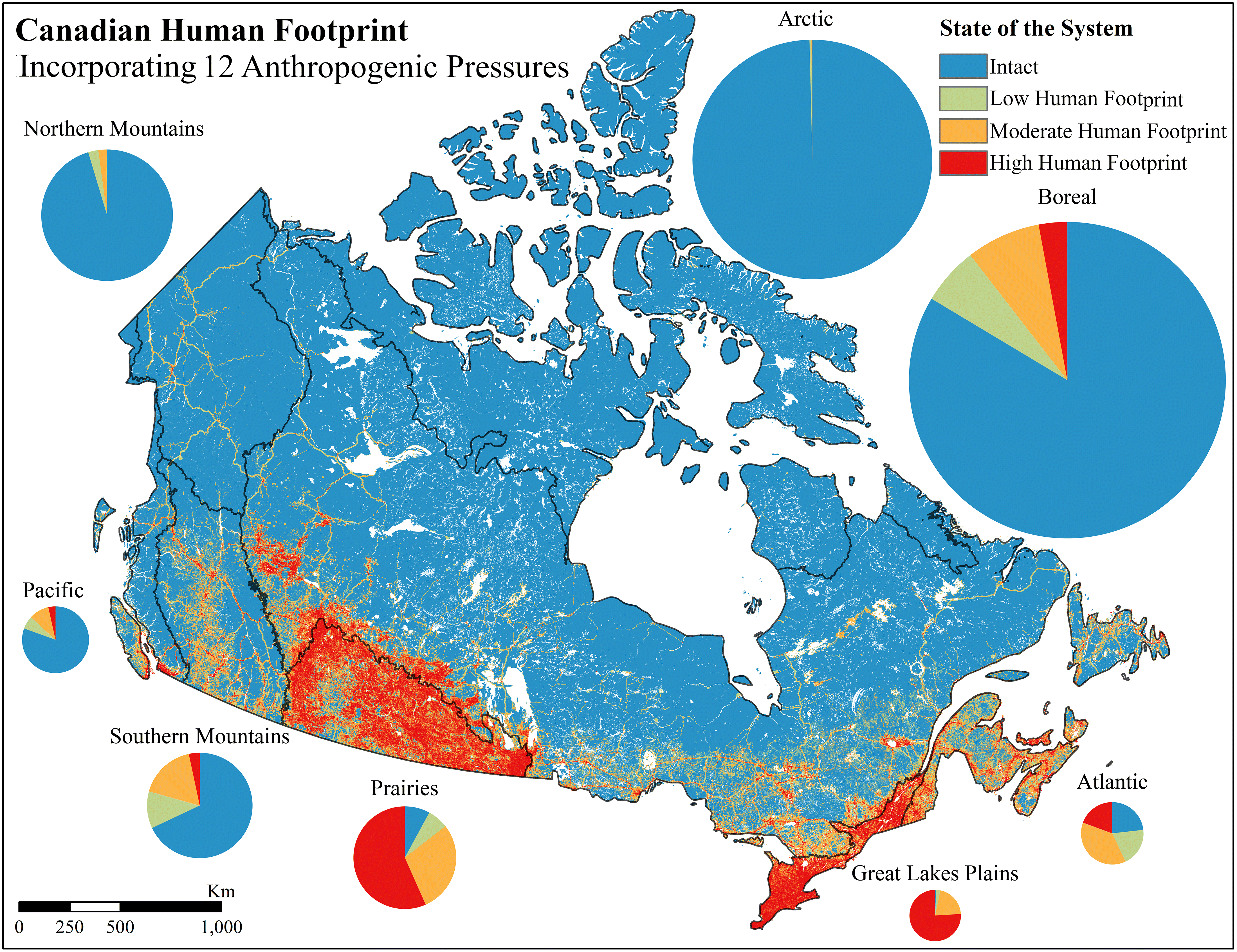
We used national ecological areas defined by COSEWIC as a means of comparing the different ecological regions of Canada (COSEWIC 2018). The human footprint differs markedly across those areas, with 84% of the Boreal ecological area, which covers the largest extent of Canada, still being intact. The Great Lakes Plains, the smallest ecological area, has 76% in the high human footprint category, being the largest percentage in the high category compared with all other ecological areas. The Prairies follow the Great Lakes Plains as the second largest values in the high human footprint category with 57%. The Great Lakes Plains has the smallest percentage in the intact category with a value of 0.6% followed by the Prairies with 8%. Conversely, the Arctic, which is the second largest ecological area, is over 99% intact.
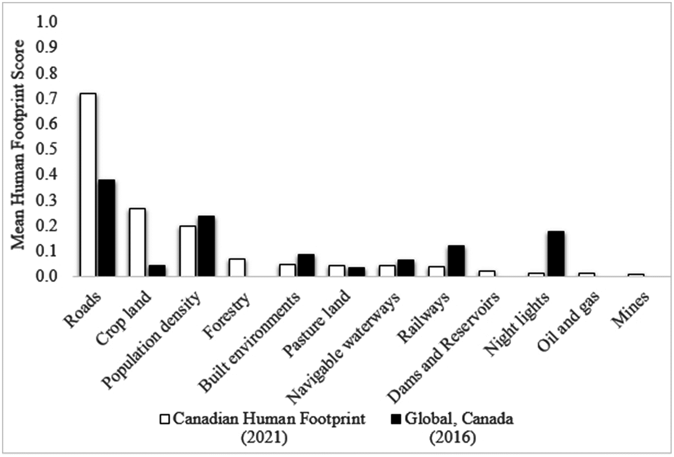
The pressure layer that contributes the most towards the mean human footprint of Canada is roads with a mean human footprint score of 0.72 (Fig. 2) and covering over 1,000,000 km2. Crop land is the second most prevalent pressure with a mean human footprint score of 0.27. The only other pressure above 0.10 was population density with a value of 0.20. In terms of extent, population density covers just under one-third of Canada, an area of 3,200,000 km2. While nighttime lights cover over 200,000 km2, they have a relatively small mean human footprint of 0.01.
Fig. 2.
Importance of National Data for Planning
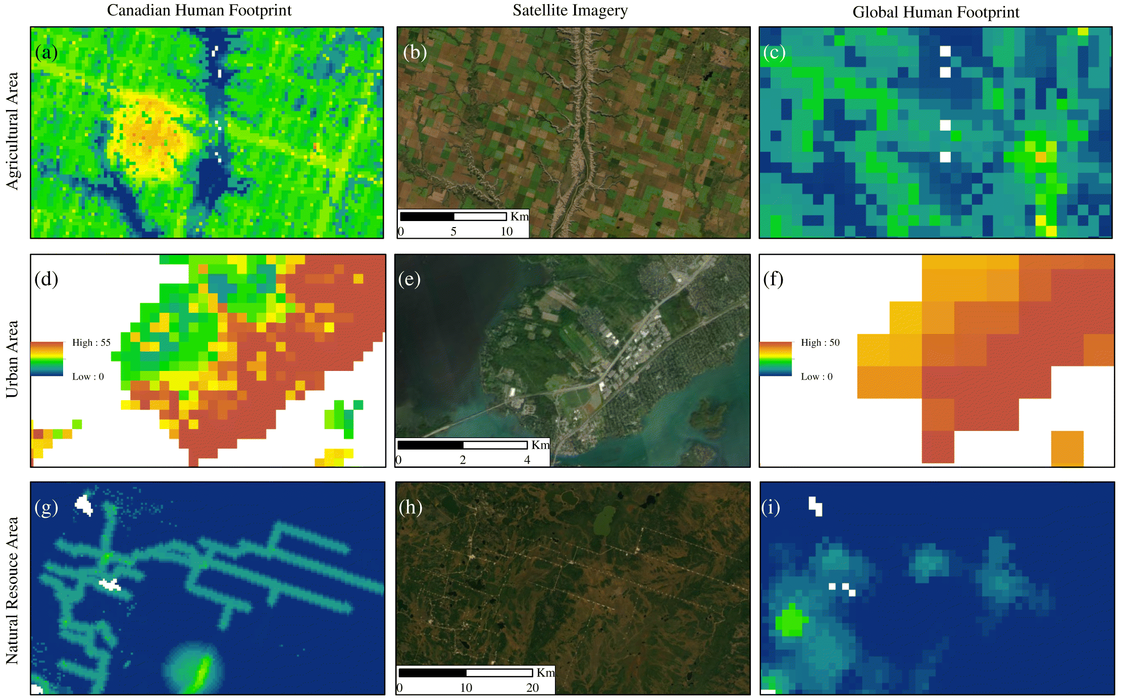
Visually comparing the global human footprint (Venter et al. 2016a) with the national version at a broad scale shows similarities in the spatial patterns of anthropogenic pressures (Supplementary Material, S2). Closer examination shows a number of variations in the details. In agricultural areas, such as the prairies ecological region, the Canadian human footprint shows a higher concentration of pressures than the global one (Figs. 3a–3c). For urban areas, the Canadian human footprint captures the distinction between areas such as parks, urban areas, and industrial areas showing a lower human footprint score than the global one (Figs. 3d–3f). In natural resource intensive areas, higher scores for the Canadian human footprint are present compared with the global product that missed these features across Canada. For example, in the boreal ecological area, forestry harvest and infrastructure from oil and gas could be included with the Canadian human footprint (Figs. 3g–3i).
Fig. 3.
When mapping nationally explicit data, the greatest improvements to the global data sets were found with the National Roads Network and the Annual Crop Inventory. The global human footprint scores roads within Canada as 50% less of a pressure than the Canadian human footprint. The Annual Crop Inventory that was used for mapping crop land for Canada captured over 285,000 km2 more than the global product (Fig. 2).
Validation results
Our validation shows a strong agreement between the Canadian human footprint measure of pressures and the pressures scored using visual interpretation of high-resolution images. The root mean squared error for 4,746 validation 1 km2 plots was 0.08 on a normalized 0–1 scale (Chai and Draxler 2014). The Cohen Kappa statistic was 0.91, signifying “almost perfect” agreement between the human footprint and the validation data set (Landis and Koch 1977; Viera and Garrett 2005). We scored 40 of the validation plots as having a pressure score 20% higher than the initial visual interpretation (false positive) and 113 were 20% lower (false negative). The remaining 4,593 plots (96.8%) were within 20% agreement. While the results from the validation represent almost perfect agreement, it appears from the higher false-negative rate that the human footprint map may be underrepresenting the pressure scores across some proportion of the country. The maps should therefore be considered as conservative estimates of anthropogenic pressures on the environment (Fig. 4). When applying a more rigorous threshold for agreement, within 15% of one another, we found that the Cohen Kappa statistic was of substantial strength with a score of 0.77. When applying a less rigorous threshold of 25%, the Cohen Kappa statistic increased to 0.95 (almost perfect strength) (Supplementary Material, S3).
Fig. 4.
We compared the validation results for the Canadian human footprint with those of the global human footprint clipped to Canada. The global human footprint obtained a root mean squared error of 0.10 on a normalized 0–1 scale for the same validation plots (Chai and Draxler 2014). For the Cohen Kappa statistic, the value was 0.76 using 20% agreement, which is considered substantial agreement between the human footprint and the validation data set, demonstrating lower agreement than the Canadian product (Landis and Koch 1977; Viera and Garrett 2005).
Discussion
This is the first undertaking to produce a continuous measure of human pressures across Canada, which we term the Canadian human footprint. While we find that the large majority of Canada is still considered intact (82%), by our definition, some ecosystems are still exposed to numerous and intense pressures. Our data set improves upon the global product by increasing the number of relevant pressures measured and by rescaling to a finer resolution using national data sets. Understanding where there are overlapping pressures on the natural system provides more insight for preventing and mitigating pressures to biodiversity than an access map of Canada that acts as a binary presence or absence of access.
Intactness in Canada
Intact areas worldwide are crucial for conserving threatened biodiversity (Di Marco et al. 2019), yet they experience increasing pressures from human land use. There is therefore a need to protect intact areas to help conserve biodiversity and ecosystem services. Furthermore, the importance of large-scale and intact ecosystems is increasing as these areas become rarer (Watson et al. 2016). When applying the 12 anthropogenic pressures to the eight national ecological areas in Canada, we find that five of those areas have a terrestrial land mass that is over 50% in an intact state. In particular, the Arctic has over 99%, the Northern Mountains has over 95%, and the Boreal follows with over 83%. This demonstrates promising opportunities for the three largest ecological areas in Canada. However, the Boreal is experiencing significant forest loss and degradation from natural resource exploration, industrial forestry, rapid climate change, and anthropogenic fires (Watson et al. 2016). Although faced with criticism, the Canadian Boreal Forest Conservation Framework provides an outline on how to protect at least 50% of the forest through a network of connected protected areas, to prevent excessive degradation, which is crucial to protect wilderness areas of Canada (Boreal Leadership Council 2003; Nishnawbe Aski Nation, n.d.).
Canada has few intact areas left in three of the eight ecological areas (Great Lakes Plains, Prairies, and Atlantic). Our human footprint shows where species are experiencing the most anthropogenic pressures and would likely have the least intact natural ecosystem for disturbance sensitive species. However, it is known that certain species can thrive in large cities and built environments (Sanderson et al. 2002). As mentioned previously, Canada’s Target 1 of 17% conservation of terrestrial lands requires those areas to be representative of the county’s ecosystems (Convention on Biological Diversity 2020). With the Atlantic, Prairies, and Great Lakes Plains areas containing less than 24%, 8%, and 1% of intact lands, respectively, it is unclear how Canada will develop protected areas that represent the ecosystems in those regions, without restoration.
Pressures on biodiversity
One of the most prevalent pressures to intactness and biodiversity are roads. The existence and expansion of roads to connect communities and resource areas are direct and indirect pressures to ecosystems, such as fragmenting habitats and by providing a means of access into intact areas (Lee and Cheng 2014; Sanderson et al. 2002). For conservation efforts, roads are one of the important pressures to address (van der Marel et al. 2020), especially in Canada where we find roads are the most prevalent pressure (Fig. 2).
Conservation planning recognises the need to understand the patterns of pressures and how they interact (Margules and Pressey 2000; Tulloch et al. 2015). When assessing national at-risk species, the Canadian Living Planet Index found a 59% decline in these at-risk populations between 1970 and 2016 (WWF Canada 2020). A global analysis of over 8,000 threatened or near-threatened species found that overexploitation was the most important pressure, followed by agricultural activities and then urban development (Maxwell et al. 2016). For our analysis, those pressures were represented by the footprint of crop land, forestry, built environments, and pasture land, all of which fall within the top six mean human footprint scores for Canada. With Canada’s at-risk species facing more than one pressure (Woo-Durand et al. 2020), the utility of the Canadian human footprint, which includes the pressures that are most affecting biodiversity (Maxwell et al. 2016), is an important tool for conservation planning and the mitigation of such pressures.
Value of national data
While the overall intensity, or the mean human footprint score, remained low for Canada, we found several differences when comparing global and national human footprints. The most significant difference in the mean human footprint score was found in nighttime lights. Nighttime lights for Canada had a mean human footprint score 18 times less than in the global human footprint. The reduction in score from the global to the national product is the result of using more recent and higher-resolution imagery that addresses saturation and spillage observed with the global product (Elvidge et al. 2013).
Producing the human footprint for Canada allows us to include data sets that are nationally relevant and offer more information and detail than many of the global footprint maps. The largest increase in mean human footprint score comes from crop land that has a mean human footprint score over six times more extensive than that in the global product. The improved accuracy for mapping crop land could be part of the reason we see higher footprint values in the Prairies when compared with the global product, as the Prairies are a large agricultural centre for the country. Furthermore, the Canadian data set for roads allowed for the inclusion of minor roads that the global data set could not include (Venter et al. 2016b). The Canadian data also led to a near doubling of the mean human footprint score for roads when compared with Canada’s score with the global data. However, there is still room for improvement in mapping linear infrastructure in Canada. When we compare the national roads with some provincial road data, we find that the national data do not capture all the resource roads and some of the smaller roads that are mapped at a provincial or territorial scale.
The global human footprint and the Canadian human footprint show the same overall patterns of pressures. However, we find more disagreements in areas where there are more cumulative pressures. By developing a finer resolution national product with Canadian data, we can measure the improvements from global human footprints and confirm the soundness of our human footprint with the almost perfect validation score. This demonstrates the importance of national studies for conservation of biodiversity and ecosystem services (Woolmer et al. 2008).
Limitations and future directions
This is the first national product for the Canadian human footprint, with room for future refinements. Firstly, linear features besides roads, such as seismic lines or outdoor recreation such as trails, should be included if possible, in future revisions. These features appeared in approximately 1% of the validation plots but were not mapped as there were no national data sets for oil and gas exploration and recreation. Also, recreation more broadly can have significant impacts (Mullins and Wright 2016) and should be included as data become available. These data should be a priority for future improvements to our work. Other pressures such as extreme weather and introduced species are important, but inherently difficult to map (Venter et al. 2006; Woo-Durand et al. 2020).
Secondly, the built environments data set did not cover the full extent of the country (only to 59°N); therefore, the theoretical max north of 59° latitude is 10 lower for the human footprint, leading to a potential underestimation of anthropogenic pressure. This is unlikely to be a major omission, as these pressures are sparse or absent above this latitude. When the Cohen Kappa statistic was calculated for the 2003 validation points above 59° latitude, we still have an “almost perfect agreement” with 0.91. Despite lower population density in the north, natural resource exploration has increased, bringing with it more temporary workers and work camps (Ensign et al. 2014). Thirdly, the data sets we used to map mining and oil and gas only provided point features. Further efforts are needed to develop complete polygon boundary and associated linear features that more accurately represent the geographic extent of the pressure. Lastly, our product is not immune to the limitations of spatial analyses such as mixed pixel problems that arise when resampling to the resolution of the project and the assumption of linear and consistent responses of ecosystems to pressures (Halpern and Fujita 2013). While there is certainly scope for further refinement, we do note that the validation of the Canadian human footprint revealed a much closer agreement between our data set and actual observable pressures than previous efforts in other jurisdictions (Venter et al. 2016a; Kennedy et al. 2019; Williams et al. 2020).
Conclusion
Our Canadian human footprint map provides a baseline from which we can measure changes in human pressures across the country and into the future. Such information is critical for assessing the effectiveness of national and international policies and agreements designed to maintain biodiversity and expand Canada’s conservation and protected lands. Our cumulative pressure map provides the first step towards being able to translate mapped pressures to the impacts of those pressures for biodiversity and ecosystem services. We demonstrate that Canada does contain large intact areas in line with Watson et al. (2016) who identified North America as with a critical stronghold for large tracts of intact wilderness. Understanding how Canada’s intact lands are lost through cumulative human activities and associated pressures is crucial for the future prevention and mitigation of biodiversity loss and degradation of ecosystem services in a country where large intact areas still remain.
Acknowledgements
Project funding was provided by University of Northern British Columbia and Natural Science and Engineering Research Council (NSERC). We are appreciative to M. Hirsh-Pearson, D. Pinkham, L. Spooner, J. Ray, and the members of the Conservation Solutions Lab for the helpful comments during the production of the manuscript. We thank S. Emmons and P. Bai for GIS support and troubleshooting. Thank you to H. Massicotte for editing help for the French abstract and keywords.
References
Allan JR, Venter O, and Watson JEM. 2017. Temporally inter-comparable maps of terrestrial wilderness and the last of the wild. Scientific Data 4: 170187.
ArcGIS, n.d. World_imagery (mapserver). ESRI, Redlands, CA. [online]: Available from services.arcgisonline.com/ArcGIS/rest/services/World_Imagery/MapServer.
Armstrong GW. 1999. A stochastic characterisation of the natural disturbance regime of the boreal mixedwood forest with implications for sustainable forest management. Canadian Journal of Forest Research 29: 424–433.
Ban N, and Alder J. 2008. How wild is the ocean? Assessing the intensity of anthropogenic marine activities in British Columbia, Canada. Aquat. Conserv. Mar. Freshw. Ecosyst. 18: 55–85.
Ban NC, Alidina HM, and Ardron JA. 2010. Cumulative impact mapping: Advances, relevance and limitations to marine management and conservation, using Canada’s Pacific waters as a case study. Mar. Policy 34: 876–886.
Bergeron DH, Pekins PJ, Jones HF, and Leak WB. 2011. Moose browsing and forest regeneration: A case study in Northern New Hampshire. Alces – A Journal Devoted to the Biology and Management of Moose 47: 39–51.
Boreal Leadership Council. 2003. Canadian Boreal Forest Conservation Framework 8.
Brine RH. 1995. Canada’s forgotten highway. 1st ed. Whaler Bay Press, Galiano, B.C. 250 p.
Brittingham MC, Maloney KO, Farag AM, Harper DD, and Bowen ZH. 2014. Ecological risks of shale oil and gas development to wildlife, aquatic resources and their habitats. Environmental Science and Technology 48: 11034–11047.
Burton AC, Huggard D, Bayne E, Schieck J, Sólymos P, Muhly T, et al. 2014. A framework for adaptive monitoring of the cumulative effects of human footprint on biodiversity. Environmental Monitoring and Assessment 186: 3605–3617.
Canter L, and Ross B. 2010. State of practice of cumulative effects assessment and management: the good, the bad and the ugly. Impact Assessment and Project Appraisal, 28: 261–268.
Chai T, and Draxler RR. 2014. Root mean square error (RMSE) or mean absolute error (MAE)? – Arguments against avoiding RMSE in the literature. Geoscientific Model Development 7: 1247.
Cincotta RP, and Engelman R. 2000. Nature’s place: Human population and the future of biological diversity. Population Action International, Washington, DC. 87 p.
Clarke Murray C, Agbayani S, Alidina HM, and Ban NC. 2015a. Advancing marine cumulative effects mapping: An update in Canada’s Pacific waters. Marine Policy, 58: 71–77.
Clarke Murray C, Agbayani S,and Ban NC. 2015b. Cumulative effects of planned industrial development and climate change on marine ecosystems. Global Ecology and Conservation, 4: 110–116.
Convention on Biological Diversity. 2020. The Convention on Biological Diversity. Secretariat of the Convention on Biological Diversity, Montreal, QC. [online]: Available from cbd.int/convention/.
COSEWIC. 2018. Cosewic/Cosepac – Guidelines for recognizing designatable units. COSEWIC, Gatineau, QC. [online]: Available from cosewic.ca/index.php/en-ca/reports/preparing-status-reports/guidelines-recognizing-designatable-units.
Crain CM, Halpern BS, Beck MW, Kappel CV. 2009. Understanding and managing human threats to the coastal marine environment. Ann. N. Y. Acad. Sci. 1162: 39–62.
Di Marco M, Ferrier S, Harwood TD, Hoskins AJ, and Watson JEM. 2019. Wilderness areas halve the extinction risk of terrestrial biodiversity. Nature, 573: 582–585.
Duinker PN, and Greig LA. 2006. The impotence of cumulative effects assessment in Canada: Ailments and Ideas for Redeployment. Environ. Manage. 37: 153–161.
Elvidge CD, Baugh KE, Zhizhin M, and Hsu F-C. 2013. Why VIIRS data are superior to DMSP for mapping nighttime lights. Proc. Asia-Pac. Adv. Netw. 35: 62.
Ensign PC, Giles A, and Oncescu J. 2014. Natural resource exploration and extraction in Northern Canada: Intersections with community cohesion and social welfare. J. Rural Community Dev. 9: 112–133.
Freedman B, Woodley S, and Loo J. 1994. Forestry practices and biodiversity, with particular reference to the Maritime Provinces of eastern Canada. Environ. Rev. 2: 33–77.
Geldmann J, Joppa LN, and Burgess ND. 2014. Mapping change in human pressure globally on land and within protected areas. Conservation Biology 28: 1604–1616.
Global Forest Watch Canada. 2010. Large dams and reservoirs of Canada.
Government of Canada; Agriculture and Agri-Food Canada; Science and Technology Branch. 2016. Annual crop inventory. [online]: Available from open.canada.ca/data/en/dataset/ba2645d5-4458-414d-b196-6303ac06c1c9.
Government of Canada; Natural Resources Canada. 2016. National railway network. [online]: Available from open.canada.ca/data/en/dataset/ba2645d5-4458-414d-b196-6303ac06c1c9.
Government of Canada; Natural Resources Canada. 2017. Principal mineral areas, producing mines, and oil and gas fields in Canada. [online]: Available from ftp.maps.canada.ca/pub/nrcan_rncan/publications/ess_sst/299/299660/as_0900A_66.zip.
Government of Canada; Statistics Canada. 2016. Geosuite, Government of Canada, Ottawa, ON. [online]: Available from geosuite.statcan.gc.ca/geosuite/en/index.
Government of Canada; Statistics Canada. 2017a. Road network file 2016. [online]: Available from ftp.maps.canada.ca/pub/nrcan_rncan/publications/ess_sst/299/299660/as_0900A_66.zip.
Government of Canada; Statistics Canada. 2017b. Population and dwelling count highlight tables, 2016 Census. Government of Canada, Ottawa, ON [WWW Document]. [online]: Available from www12.statcan.gc.ca/census-recensement/2016/dp-pd/hlt-fst/pd-pl/Table.cfm?Lang=Eng&T=101&S=50&O=A.
Haase D. 2009. Effects of urbanisation on the water balance – A long-term trajectory. Environmental Impact Assessment Review 29: 211–219.
Halpern BS, Frazier M, Potapenko J, Casey KS, Koenig K, Longo C, et al. 2015. Spatial and temporal changes in cumulative human impacts on the world’s ocean. Nature Communications 6: 7615.
Halpern BS, and Fujita R. 2013. Assumptions, challenges, and future directions in cumulative impact analysis. Ecosphere 4: art131–11.
Halpern BS, McLeod KL, Rosenberg AA, and Crowder LB. 2008. Managing for cumulative impacts in ecosystem-based management through ocean zoning. Ocean and Coastal Management, 51, 203–211.
Jacobson AP, Riggio J, Tait A, and Baillie EMJ. 2019. Global areas of low human impact (‘Low Impact Areas’) and fragmentation of the natural world. Scientific Reports, 9: 14179.
Jarvis A, Touval JL, Schmitz MC, Sotomayor L, and Hyman GG. 2010. Assessment of threats to ecosystems in South America. Journal of Nature Conservation, 18: 180–188.
Johnson CJ. 2016. Defining and identifying cumulative environmental, health, and community impacts, in: The integration imperative – Cumulative environmental, community and health effects of multiple natural resource developments. Springer International Publishing, pp. 21–45.
Jones NF, Pejchar L, and Kiesecker JM. 2015. The energy footprint: How oil, natural gas, and wind energy affect land for biodiversity and the flow of ecosystem services. Bioscience, 65: 290–301.
Kauffman JB, and Krueger WC. 1984. Livestock impacts on riparian ecosystems and streamside management implication A Review. Rangeland Ecology & Management Archives, 37: 430–438.
Kennedy CM, Oakleaf JR, Theobald DM, Baruch-Mordo S, and Kiesecker J. 2019. Managing the middle: A shift in conservation priorities based on the global human modification gradient. Global Change Biology, 25: 811–826.
Landis JR, and Koch GG. 1977. The Measurement of observer agreement for categorical data. Biometrics 33: 159–174.
Lee P, and Cheng R. 2014. Human access in Canada’s landscape, Global Forest Watch Canada bulletin. Global Forest Watch Canada.
Lieffers VJ, Pinno BD, and Stadt KJ. 2002. Light dynamics and free-to-grow standards in aspen-dominated mixedwood forests. Forestry Chronicle 78: 137–145.
MacKinnon D, Lemieux CJ, Beazley K, Woodley S, Helie R, Perron J, et al. 2015. Canada and Aichi Biodiversity Target 11: understanding ‘other effective area-based conservation measures’ in the context of the broader target. Biodiversity and Conservation, 24: 3559–3581.
Mann J, and Wright P. 2018. The human footprint in the Peace River Break, British Columbia (No. 2), Technical Report Series. Natural Resources and Environmental Studies Institute, University of Northern British Columbia, Prince George, BC.
Margules CR, and Pressey RL. 2000. Systematic conservation planning. Nature, 405: 243–253.
Maxwell SL, Fuller RA, Brooks TM, and Watson JEM. 2016. Biodiversity: The ravages of guns, nets and bulldozers. Nat. News, 536: 143.
McCune JL, Colla SR, Coristine LE, Davy CM, Flockhart DTT, Schuster R, and Orihel DM. 2019. Are we accurately estimating the potential role of pollution in the decline of species at risk in Canada? FACETS,
Mullins P, and Wright P. 2016. Connecting outdoor recreation, community, and health in living landscapes, in: The integration imperative: Cumulative environmental, community and health impacts of multiple natural resource developments. Springer International AG.
Newbold T, Hudson LN, Hill SLL, Contu S, Lysenko I, Senior RA, et al. 2015. Global effects of land use on local terrestrial biodiversity. Nature 520: 45–50.
Nishnawbe Aski Nation. n.d. Canadian Boreal Forest Agreement. Nishnawbe Aski Nation, Thunder Bay, ON. [online]: Available from nan.on.ca/article/canadian-boreal-forest-agreement-462.asp.
NOAA. 2019. Version 1 VIIRS Day/Night Band Nighttime Lights.
O’Donnell B. 1989. Indian and Non-Native use of Nitinat Lake and River an historical perspective, Native Affairs Division, Policy and Program Planning. Fisheries and Oceans Canada.
Pasher J, Seed E, and Duffe J. 2013. Development of boreal ecosystem anthropogenic disturbance layers for Canada based on 2008 to 2010 Landsat imagery. Canadian Journal of Remote Sensing 39: 42–58.
Prebble M, and Wilmshurst JM. 2009. Detecting the initial impact of humans and introduced species on island environments in Remote Oceania using palaeoecology. Biological Invasions, 11: 1529–1556.
Primack RB. 1993. Essentials of Conservation Biology. Sinauer Associates Inc.
Ricketts T, and Imhoff M. 2003. Biodiversity, urban areas, and agriculture: Locating priority ecoregions for conservation. Conservation Ecology, 8.
Robb CK. 2014. Assessing the impact of human activities on British Columbia’s estuaries. PLoS ONE, 9: e99578.
Sala OE, Chapin FS, Armesto JJ, Berlow E, Bloomfield J, Dirzo R, et al. 2000. Global biodiversity scenarios for the year 2100. Science, 287: 1770–1774.
Sanderson EW, Jaiteh M, Levy MA, Redford KH, Wannebo A, Woolmer G. 2002. The human footprint and the last of the wild. Bioscience, 52: 891–904.
Shackelford N, Standish RJ, Ripple W, and Starzomski BM. 2017. Threats to biodiversity from cumulative human impacts in one of North America’s last wildlife frontiers. Conservation Biology, 32, 672–684.
Sinclair K, Rawluk A, Kumar S, and Curtis A. 2017. Ways forward for resilience thinking: lessons from the field for those exploring social-ecological systems in agriculture and natural resource management. Ecology and Society, 22.
Siry JP, Cubbage FW, and Ahmed MR. 2005. Sustainable forest management: global trends and opportunities. Forest Policy and Economics, 7: 551–561.
Smith HC. 1983. Growth of Appalachian hardwoods kept free to grow from 2 to 12 Years after clearcutting. Res Pap NE-528 Broomall PA US Dep. Agriculture, Forest Service, Northeastern Forest Experiment Station, p. 528.
Steffen W, Richardson K, Rockström J, Cornell SE, Fetzer I, Bennett EM, et al. 2015. Planetary boundaries: Guiding human development on a changing planet. Science, 347: 1259855.
Sterling SM, Garroway K, Guan Y, Ambrose SM, Horne P, and Kennedy GW. 2014. A new watershed assessment framework for Nova Scotia: A high-level, integrated approach for regions without a dense network of monitoring stations. Journal of Hydrology 519 Part C: 2596–2612.
Tapia-Armijos MF, Homeier J, and Draper Munt D. 2017. Spatio-temporal analysis of the human footprint in South Ecuador: Influence of human pressure on ecosystems and effectiveness of protected areas. Applied Geography 78, 22–32.
Tratalos J, Fuller RA, Warren PH, Davies RG, and Gaston KJ. 2007. Urban form, biodiversity potential and ecosystem services. Landsc. Urban Plan. 83: 308–317.
Trombulak SC, and Frissell CA. 2000. Review of ecological effects of roads on terrestrial and aquatic communities. Conservation Biology 14: 18–30.
Tulloch VJ, Tulloch AI, Visconti P, Halpern BS, Watson JE, Evans MC, et al. 2015. Why do we map threats? Linking threat mapping with actions to make better conservation decisions. Frontiers in Ecology and the Environment 13: 91–99.
van der Marel RC, Holroyd PC, and Duinker PN. 2020. Managing human footprint to achieve large-landscape conservation outcomes: Establishing density limits on motorized route-user networks in Alberta’s Eastern Slopes. Global Ecology and Conservation, 22: e00901.
Venter O, Brodeur NN, Nemiroff L, Belland B, Dolinsek IJ, and Grant JWA. 2006. Threats to endangered species in Canada. Bioscience, 56: 903–910.
Venter O, Sanderson EW, Magrach A, Allan JR, Beher J, Jones KR, et al. 2016a. Sixteen years of change in the global terrestrial human footprint and implications for biodiversity conservation. Nature Communications, 7: 12558.
Venter O, Sanderson EW, Magrach A, Allan JR, Beher J, Jones KR, et al. 2016b. Global terrestrial human footprint maps for 1993 and 2009. Scientific Data, 3: 160067.
Viera AJ, and Garrett JM. 2005. Understanding interobserver agreement: The kappa statistic. Family Medicine, 37: 360–363.
Waller D, and Reo N. 2018. First stewards: Ecological outcomes of forest and wildlife stewardship by indigenous peoples of Wisconsin, USA. Ecology and Society,
Watson JEM, Shanahan DF, Di Marco M, Allan J, Laurance WF, Sanderson EW, et al. 2016. Catastrophic declines in wilderness areas undermine global environment targets. Current Biology, 26: 2929–2934.
Westwood A, Barker N, Grant S, Amos A, Camfield A, Cooper K, et al. 2020. Toward actionable, coproduced research on boreal birds focused on building respectful partnerships. Avian Coservation and Ecology, 15.
White JC, Wulder MA, Hermosilla T, Coops NC, and Hobart GW. 2017. A nationwide annual characterization of 25years of forest disturbance and recovery for Canada using Landsat time series. Remote Sensing of Environment, 194: 303–321.
Williams BA, Venter O, Allan JR, Atkinson SC, Rehbein JA, Ward M, et al. 2020. Change in terrestrial human footprint drives continued loss of intact ecosystems. One Earth, 3: 371–382.
Woo-Durand C, Matte J-M, Cuddihy G, McGourdji CL, Venter O, and Grant JWA. 2020. Increasing importance of climate change and other threats to at-risk species in Canada. Enviromental Reviews, er-2020-0032.
Woolmer G, Trombulak SC, Ray JC, Doran PJ, Anderson MG, Baldwin RF, et al. 2008. Rescaling the human footprint: A tool for conservation planning at an ecoregional scale. Lanscape and Urban Planning, 87: 42–53.
WWF Canada. 2003. The Nature Audit: Setting Canada’s conservation agenda for the 21st century (No. 1). World Wildlife Fund Canada, Toronto, Canada.
WWF Canada. 2020. Living Planet Report Canada 2020 – Wildlife at risk. WWF Canada, Toronto, ON.
Supplementary material
Supplementary Material 1
- Download
- 2.92 MB
Supplementary Material 2
- Download
- 343.90 KB
Supplementary Material 3
- Download
- 51.26 KB
Supplementary Material 4
- Download
- 114.64 KB
Information & Authors
Information
Published In

FACETS
Volume 7 • Number 1 • January 2022
Pages: 398 - 419
Editor: Raymond Bradley
History
Received: 26 May 2021
Accepted: 9 November 2021
Version of record online: 17 March 2022
Copyright
© 2022 Hirsh-Pearson et al. This work is licensed under a Creative Commons Attribution 4.0 International License (CC BY 4.0), which permits unrestricted use, distribution, and reproduction in any medium, provided the original author(s) and source are credited.
Data Availability Statement
All relevant data are within the paper, the Supplementary Material, and at https://doi.org/10.5683/SP2/EVKAVL.
Key Words
Mots-clés
Sections
Subjects
Plain Language Summary
Mapping human influence in Canada shows many areas under heavy human pressure while other areas are largely intact
Authors
Author Contributions
All conceived and designed the study.
KH-P performed the experiments/collected the data.
All analyzed and interpreted the data.
All contributed resources.
All drafted or revised the manuscript.
Metrics & Citations
Metrics
Other Metrics
Citations
Cite As
Kristen Hirsh-Pearson, Chris J. Johnson, Richard Schuster, Roger D. Wheate, and Oscar Venter. 2022. Canada’s human footprint reveals large intact areas juxtaposed against areas under immense anthropogenic pressure. FACETS.
7(): 398-419. https://doi.org/10.1139/facets-2021-0063
Export Citations
If you have the appropriate software installed, you can download article citation data to the citation manager of your choice. Simply select your manager software from the list below and click Download.
Cited by
1. Prioritizing taxa for genetic reference database development to advance inland water conservation
2. Predicting areas important for ecological connectivity throughout Canada
3. Integrating carbon stocks and landscape connectivity for nature‐based climate solutions
4. Integrative adaptive management to address interactions between biological invasions and protected area connectivity: a Canadian perspective
5. Land use/cover spatiotemporal dynamics, and implications on environmental and bioclimatic factors in Chingola district, Zambia
6. Transformational changes for achieving the Post-2020 Global Biodiversity Framework ecological connectivity goals