A century of knowledge: Kwakwaka’wakw Elders and environmental change
Abstract
This paper reviews a century of Kwakwaka’wakw knowledge on ecological, climate, and social change. We trace the era of Indigenous governance (about the precolonial period), especially from about 1910 to the devastation of the flood in Dzawada’enuxw First Nation territory in Kingcome, British Columbia, in 2010. This time period has been chosen as the assessment period as this is the lifetime of the 10 Elders that we collaborated with to understand and position change during this tumultuous era. We call the results of this process “a century of knowledge”. Ecological, social, and climate change are positioned with scientific literature for potential divergence/convergence. Almost all aspects of the Kwakwaka’wakw home area have undergone large-scale changes including clear-cut forestry, salmon farms, climate change affecting species ranges, cultural impositions, and colonial processes working to destroy Indigenous governance. Despite these imposed changes, the communities emerge as survivors on their own terms, including using the traditional feast system known as the Potlatch to come to terms with the devastation of the 2010 flood and beyond.
Introduction
“Because there’s no really good study done on climate change. Because we don’t have the knowledge to do it. We see the problem. The climate change changes everything big time. You see it all over the world. Because we don’t have any control. We don’t have a voice!”—Alfred “Baker” Coon (Supplementary material, item BW1)1
The Kwakwaka’wakw (formerly known also as Kwakiutl), meaning Kwak’wala-speaking First Nations are an Indigenous language and cultural group located on the western coast of Canada. Both Indigenous knowledge and science points to thousands of years of use and occupancy by the Kwakwaka’wakw in their present home regions (see Dick et al. In press).
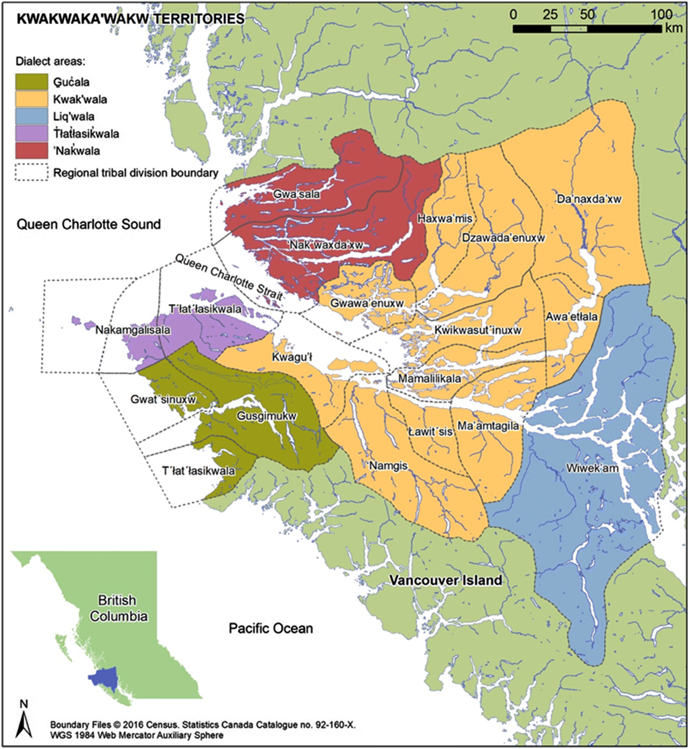
During precontact times the Kwakwaka’wakw were a sovereign governance body/bodies divided into nations/“tribes” and families. Central to the governance of these nations was the feast system that is known in literature as “Potlatch”; the Potlatch system is defined by the U’mista Cultural Society (2021) in the Supplementary Material. Figure 1 shows a map of the Kwakwaka’wakw Territories.
Fig. 1.
Colonial attacks2 on the Indigenous governance system began with early contact with European colonial powers in 1792 (Schreiber 2006) and included an outright ban of potlatching between 1885 and 1951. The Kwakwaka’wakw continued to exercise their governance, culture, and practice, holding Potlatches in secret during the ban (Williams 2001; Reid and Sewid-Smith 2004; Deur et al. 2015; Mustonen et al. 2021) or holding them in conjunction with celebrations like weddings and Christmas to mask their main purpose. Today the Potlatch institution, albeit reflecting changing times, is still the backbone of the culture and community life.
“We never gave up our rights to the land, we never gave up our traditional ways. When you talk about the Potlatch system, the government tried to wipe that out. Threw my great-grandfather to jail for six months for practicing the Potlatch.”—Brian Wadhams (Supplementary material, item BW2)
Kwakwaka’wakw leaders like Kwaxsistalla Chief Adam Dick (Turner 2005; Deur et al. 2015) were traditionally trained and maintained protocols, wisdom, knowledge, and cultural heritage, including the knowledge and histories passed on within the Potlatch ceremonies, throughout the 1900s despite immense changes. Chief Dick and the Elders featured in this paper maintained the endemic (Turner et al. 2013; Mustonen 2014; Mustonen et al. 2021) biocultural concepts of the respective Kwakwaka’wakw nations, embedded within the Kwak’wala language. For example, the concepts of
•
q´waq´wala7owkw, meaning “keeping it living” (Deur and Turner 2005; Turner 2005) or “deep management” (as per Turner et al. 2013) reflects the Indigenous governance of the region.
•
Webster (2001) mentioned ‘Ma’wa’etlanx, a “time to head into the inlet”, pointing to the seasonal time for the eulachon harvests in Kingcome Inlet.
•
Deur et al. (2015) highlighted the concept of walamox’galis, “average lowest low-tide line”.
A central element of the Potlatch governance was, and continues to be, the Elder institution. In the ranking system of the hierarchies of the Kwakwaka’wakw, each family and Elder was honored based on their status. The Finn Kaapro Jääskeläinen, a Sointula resident, visited Alert Bay, British Columbia, and wrote about his observations in a book, including a description of Kwakwaka’wakw social life (Jääskeläinen 1907, p. 52–57):
“Those who know the internal workings of the Indian society here, claim that they are perfect natural socialists. They share common fishing grounds, lands, forests, all areas of subsistence, this means production sources. If somebody gets rich for this or that reason, he gives everything away divided even among the tribe!” (Supplementary material, item KJ1)
Kwakwaka’wakw have historically been called “salmon people” (Schreiber 2006). Vodden et al. (2006, p. 13) added: “They call us a salmon people. We are also a cedar people.” (Supplementary material item CC1). This notion arises from the prominent role that the five Pacific salmon species and western redcedar have played and continue to play in the center of the culture, economy, and food security for the communities. Cullon (2013) provided an overview of salmon as a cultural keystone species. Additionally, Garibaldi and Turner (2004) confirmed the role of salmon and western redcedar being significant for the Kwakwaka’wakw culture.
In Canadian society, salmon has been generally seen in its various forms as a common property resource, i.e., for all to use ).3 There are five different Pacific salmon species (Augerot 2005; Table 1).
Table 1.
| English | Latin | Kwak’wala | Local uses (from Sanborn 2004) |
|---|---|---|---|
| Sockeye salmon | Oncorhynchus nerka | malik | Fresh food, mostly barbecued over an open fire; baked and fried; canned fresh or smoked, and dried and smoked (this is called K’awas); salmon eggs also utilized |
| Chum or dog salmon | Oncorhynchus keta | gwax’nis | Smoked in the fall, when weather is cooler and the chums enter the river |
| Chinook or spring salmon | Oncorhynchus tshawytscha | sat’sam | Used as an Indigenous food staple |
| Coho salmon | Oncorhynchus kisutch | dza’wa’n | Used as an Indigenous food staple |
| Pink salmon | Oncorhynchus gorbuscha | hanu’n | Not often used, but sometimes smoked and canned |
The context of our work began with visits to Alert Bay in 2001 and 2002.4 In 2003, the Finnish nonprofit Snowchange Cooperative was invited by the U’mista Cultural Society and the Kwakiutl Territorial Fisheries Commission to work with a number of ‘Namgis and Dzawada’enuxw First Nation Elders on oral histories of climate and environmental change.5 Biographies of the Elders involved in the work can be found in the Acknowledgements. We focus here on the historical period between 1910 and 2010, beginning with the era when many of these recorded Elders were born. Our research ends with the devastating flood of the Kingcome River in 2010, which had a major impact on the Dzawada’enuxw at Kingcome village. Throughout this work, the role of the authors was to respond to the First Nations wishes to investigate climate and environmental change in the region and to facilitate the overall process. The Elders provided an overall corpus of oral histories.
In this research article we position the knowledge, wisdom, and observations of a changing Kwakwaka’wakw homeland and environment shared by 10 Kwakwaka’wakw Elders with scientific knowledge. By co-writing and co-learning6 with these Elders, this article will summarize the Kwakwaka’wakw Indigenous Knowledge over a century of change (as partially adapted from Turner and Turner 2008; see also Dick et al., In press). Scientific knowledge here is drawn from statistical summaries of data (including surface air temperature, precipitation, and ocean temperatures) and a review of peer-reviewed literature. We evaluate the convergences and divergences that occurred when Indigenous knowledge and scientific knowledge were placed into dialogue. Often scientific methods and short-term data availability, spanning at most 100 years, do not provide an adequate view of interconnected and entwined causes of and responses to change. We seek in this paper to understand how and why these knowledge streams converge and diverge to understand a more complete view of changes that have occurred and possible solutions.
Of topical importance and symbolic value will be the review of cultural responses to the devastation of the 2010 Kingcome Flood involving two Potlatches in Alert Bay, a central modern Kwakwaka’wakw community. The paper concludes with messages of wisdom and the ethics of good relations with the sea, land, and nature based on the Elders’ oral histories.
We believe that through this process of understanding the century of change it will be possible to better position the events of the 21st century within a long-term continuum that is only possible through Indigenous knowledge. It is important to understand the acts of Indigenous-led monitoring, equity narratives, and the continued valorisation of ceremony (here, the Potlatch) as strategic responses from the Indigenous Peoples as they navigate the complex century of change. We highlight and assess these interlinked elements in the paper and in the conclusions section we summarize our understanding of how Indigenous knowledge holders position change and what Indigenous perspectives on solutions looks like.
1
Further context and (or) full quotes from oral history participants is provided in the Supplementary material by item cited.
2
Such as the establishment of the Indian Act in 1876 and imposing alternate “chief and band systems”, (see Newell and Schreiber, 2007).
3
From the state viewpoint, the Province of British Columbia administers the various industrial uses of waters (e.g., hydropower) as well as terrestrial land uses (forestry, mining, and those described in Turner and Turner 2008) that affect salmon in the rivers and other freshwater ecosystems (McGillivray 2000). Whilst the Fisheries Act makes salmon and the stocks a Federal matter, the surrounding land and aquatic decision-making at the provincial level influence the fish survival and well-being. Historically, to the Kwakwaka’wakw, such divisions were of little importance.
4
Alert Bay is located on Cormorant Island, off the northeast coast of Vancouver Island, British Columbia. The island-wide community of approximately 1300 residents lies within the traditional territory of the ‘Namgis First Nation. The island includes several political and administrative jurisdictions and governance bodies, principally the ‘Namgis First Nation and Village of Alert Bay. The cash economy is bolstered by a threatened but still relatively healthy informal or noncash economy as well as by strong community spirit and willingness to look after one another when times are tough (Vodden et al. 2006).
5
Over the years a book (Helander and Mustonen 2004; Eklund 2004) and several workshops (2005, 2006, 2010, see Vodden et al. 2006) have conveyed some of the results of this long-term oral history work on the community level.
6
This science article is a product of an almost 20-year engagement with the community and the Elders who are quoted here. Many of them have passed on already. We define their role as co-producers of the present article as they informed and contextualized the change that has happened and also the major events of the past century. By including their direct oral histories, we hear from the authentic voices of the Elders on the issues. The primary authors of the article have then conducted the science and geographical analysis of the centurial issues presented here.
Materials and methods
In July 2002 U’mista Cultural Society and the Kwakiutl Territorial Fisheries Commission invited the Finland-based Snowchange Cooperative to investigate environmental and climate change knowledge, originally with eight Elders co-researching. Between 2003 and 2006 the primary oral history work was carried out with the consenting and community-chosen Elders, most of whom were or had been involved in the marine fisheries. Oral history documentation happened at the preferred locations and times of the Kwakwaka’wakw Elders, at their homes, in boats, or outside. The individual meetings with the eight Elders were recorded, with consent, on digital recorders, and consent forms were collected.7 Copies of the tapes and texts are deposited with the U’mista Cultural Society and the Kwakiutl Territorial Fisheries Commission located in Alert Bay. In all processes the principle of Free, Prior, and Informed Consent (FPIC) was followed. Strong cohesion of the overall aims of the work permeated throughout as the parties to the research operated with common values and goals. This cohesion in the research process arose from (i) the tight community and their informed priorities who shared their concerns and values and (ii) long-term engagement of the authors (Eklund lived in the community on and off for several years, and Mustonen is an adopted member of the First Nation, engaging with the community members for over two decades).
The devastating floods of 2010 that impacted Dzawada’enuxw First Nation at Kingcome Inlet led to a set of Potlatches (in 2010 and 2012) that the communities organized to come to terms with the changes from climate-related extreme rain events that were aggravated by human-induced land use changes (such as logging). Whilst flooding had happened in the past, the scale and social and physical toll of the 2010 flood surpassed all historical experience in the communities.
Huntington et al. (2017) defined the concept of “autonomous response space” as the possible responses to change that a community can make on its own (for example, changing the timing and location of activities, using different species, or self-governing other individual or organized actions). We discuss these two Potlatches as examples of autonomous response spaces of the Kwakwaka’wakw.
Oral history research (Macdonald 2000; Mustonen and Shadrin 2021) is a powerful method to document “unknown” drivers of change in the northern communities. Given the dynamic environment of the Kwakwaka’wakw home area (for example in terms of archipelago ecosystems, the Pacific sea currents, mountains, large rivers, glaciers, productive food chains resulting in many apex predators), change itself, especially over a century, is constant.
Scientific materials, including climate and biological data and research, were sourced from publicly available data sets from government and other sources (cited within the text) and literature review. The scientific materials are viewed alongside the other streams of knowledge to investigate how and why they converge or diverge, and how that understanding can lead to better approaches to responding to change.
7
Over 30 hours of interviews (methods described in Huntington, 2000) constituted the primary oral history corpus for the work. The primary time span of these oral histories covers the time between 1910 and 2010 (from the birth of many of the Elders to the 2010 Kingcome flood events). Each oral history tape was transcribed and brought back to the individual co-researcher for approval. Between 2004 and 2010 the materials were published in a set of gray literature reports (Helander and Mustonen 2004), and a set of community workshops (see, for example, Vodden et al. 2006) were held in Alert Bay to share the key wisdom and messages to the Kwakwaka’wakw community and the Elders themselves.
Results
Our analytical frame will be the time between 1910 and 2010. Whilst we are aware of the linear nature of a “Western” timeframe (Macdonald 2000) and the fact that Indigenous Peoples may perceive time, space, events, and meaning differently (Sheridan and Longboat 2006). We are using this “centennial” view to summarize and discuss the main knowledge that was shared with us, providing a summary of events up to this time period. While the space does not allow for a full recounting of each year, we mark regionally significant changes and events below and reflect on them in the context of multiple knowledge streams.
Distant past
Precontact and the time before written history (myth times) can be seen as an era of full Indigenous governance of the Kwakwaka’wakw peoples and nations (Bouchard and Kennedy 2006; Williams 2001; Reid and Sewid-Smith 2004; Bouchard and Kennedy 2006; Deur et al. 2015). However, given the immense length of cultural continuum in the home area change was a major constant, whether in terms of natural (weather, ecological and oceanic events) or social (trade, war, alliances, depopulation of remote villages, movement of the Kwakwaka’wakw across their spaces over centuries; see Reid and Sewid-Smith 2004) systems. One of the universally recognized cultural forms of environmental knowledge (Macdonald 2000) is traditional weather prediction (Supplementary material, “On weather prediction”). For the lack of another term, in this paper we call this thousands of years-long process the “Indigenous governance era”.
“In the old times we didn’t believe in borders. But these days they made (them) because they wanted to make land claims. But in the old days they didn’t believe in that.”—Alfred “Baker” Coon (Supplementary material, item AC1)
Colonial era begins: circa 1781–1858
In 1781 Kwakwaka’wakw peoples met with the European explorers for the first time (Boas 1966). This is a significant year when the Indigenous nations of their home regions came into a range of relations with the expanding European trade, conquest, and discovery expeditions. In this section we review a number of oral histories that convey the sense of place, traditional subsistence and (or) management practices, traditional economies and a way of life as perceived from the Indigenous viewpoint. It is in line with Indigenous evaluation of the past that links then with the present (Huntington et al. 2017).
Subsequent years 1781–1910 mark the increasing impact of these relations and ultimately, full colonization of the Kwakwaka’wakw peoples. The first smallpox epidemic hit the coast in 1781–1782 with disruptions of life, culture, trade, and autonomy (Boyd 1994). Brian Wadhams reflects on the Indigenous ways of being, which are partly still in use, compared to the governmental practices, saying: “One of the things you’ve got to understand, there was a protocol that went from each First Nation up and down this coast” (Supplementary material, item BW3).
Chas Coon confirms the sense of belonging to specific places when he shared that: “Most of them have their own places where they go. Places around here.” Roy Cranmer’s confirmation of the continuation of the traditional land and ocean uses is demonstrated in this narrative:
“The Nimpkish (River). That’s where we used to get all our fish before, we didn’t have to go anywhere else to get fish. Everything was there that we needed. But I guess the other thing you could probably point out is that we do go out up to Knights Inlet for the eulachons to make the grease. Every tribe in this area has got a place in Knights Inlet for doing that, for making grease. It’s kind of a shared thing.”
Continued land and ocean uses are also visible in an oral history from Brian Wadhams:
“I go everywhere! In our traditional territory. For clams, I dig clams for food and ceremonial purposes, I hunt all over in the mainland and Vancouver Island, ground fish all over in the mainland and Johnstone Strait, food fishery for Johnstone Strait for sockeye, pinks. So, I basically use the whole territory…” (Supplementary material, item BW4).
Eddie MacDougall outlined the time it takes to learn to fish out in the ocean, a form of place-based, or “ethnoecological” knowledge” (see Berkes 2018):
“Tide is not the easiest thing in our area. It took me eight years to learn our spot, and probably still another three more, before I’ve really perfected it. But for commercial, yeah, I went to one spot, and I perfected it and not too many people can do that. I fished with my dad, there was no pressure. There was no pressure probably until I was about 17 years old, when he taught me how to fish, where to catch fish.” (Supplementary material, item EM1).
Natural resources era emerges: from 1850s onwards to 1910
McGillivray (2000) outlined the beginning of industrial forestry in 1820–1830 with the demand for trees to use as masts for sailing fleets. Proliferation of saw mills sped up with the completion of the Canadian Pacific Railway in 1886. The coastal forests played a significant important role from the beginning because of the capacity to float the timber to the saw mills and harbours by 1890s (McGillivray 2000).8
The gold rush that began around 1858 also affected the river health and spawning groups at least in the Fraser River system. After 1858 the Kwakwaka’wakw peoples faced a massive range of transformative impacts, from removal of Indigenous governance, epidemics, competition of trade and resources, and loss of life McGillivray (2000) noted that between 1835 and 1885 the Kwakwaka’wakw lost over 7000 or over 70% of their total population) and land (Mustonen 2003 described deterritorialization).
Importantly for our inquiry, for the most part, the Kwakwaka’wakw peoples did not sign historic treaties with the colonizing powers; this means their area is still mostly an unceded territory (with awareness of the two Douglas Treaties of 1850 in Fort Rupert). One of the most important losses of Indigenous governance, that directly influenced the Kwakwaka’wakw peoples, was the banning of the Potlatch and other feasts in 1884 (McGillivray 2000; Umista 2021). The Potlatch was potentially seen as inappropriate for the assimilative agendas of the church and state, and ultimately it was seen as a competing governance system to the newly arrived settler law. With a slightly different focus, Menzies (2016) wrote that government saw the First Nations mostly as competing for land and resources and this led to the policy of assimilation.
Rise and fall of salmon canneries
In the golden age of salmon canneries, the canneries proliferated in 1870s and peaked in the Kwakwaka’wakw home area between 1871 (entrance of British Columbia into the Confederation) and 1903, with a mechanical canning era lasting to 1913 (McGillivray 2000). The canneries emerged to export salmon to foreign markets without affecting its taste and to allow salmon to be preserved to facilitate both its long-range transportation and long shelf-life. These capacities were necessary for the industrialization of the salmon fishery and the commodification of these fish for a nonindigenous market economy. These increased industrial actions had a disruptive impact on the traditional settlement patterns and fisheries.
“That rivers Inlet was full of canneries and that inlet looked like a city. And all our families would go up there in the summertime, eh? They had houses for them and worked in the cannery. There used to be a lot of fish.”—Chas Coon
The 1898 Yukon Gold Rush led to a peak in demand for the canned fish, as gold prospectors utilized them (partly due to the requirements of the government who demanded food security of the prospectors heading alone into the “wilderness”). From 1907 onwards, the arrival of motor engines for boats sped up the access to fishing grounds, allowing the fishing boats to travel further from the shore for their harvests, especially gillnetting. This resulted in an increase in salmon harvesting.
“Plentiful! When I was young, our grandparents used to say that you could walk on the river on top of the salmon, it was so plentiful! And it was so for months. But you have to go back. If you really want to research, go to the reserves. Where the river systems are. Years ago they used to have so much salmon that big barges couldn’t do a lot of cannery…just pump it out.”—Alfred “Baker” Coon
Elders’ century 1910–2010
The years 1910–2010 mark the century during which most of our co-authoring Elders lived their lives and observed changes, enduring cultural patterns and survival. We call it for the purposes of this paper the Elders’ Century.
Beginning in the 1910s the linear patterns of logging due to the use of steam engines and steam donkeys increased the sites harvested (McGillivray 2000). Reports from 1911 indicate 2 000 000 m3 were harvested from private lands in British Columbia (McGillivray 2000). The 1912 McKenna–McBride Commission worked from 1912 to 1916 to contextualize the land rights question for the Kwakwaka’wakw and other First Nations. Afterwards they proceeded to allocate lands to willing settlers for mostly agricultural use (McGillivray 2000). The work of the Commission had a signigicant effect on the land base of British Columbia.
In 1913 the Hell’s Gate rockslide was instigated by a blasting event that blocked the Fraser salmon from accessing further upstream on a fourth cycle year for the sockeye (McGillivray 2000). This had vast consequences for sockeye salmon numbers afterwards because the blockage prevented access to spawning sites. This was also the year that saw the end of the mechanical canneries on the coast (McGillivray 2000).
Turner and Turner (2008; see also in Williams 2001) documented Chief Cesaholis’s efforts, in his testimony to the McKenna–McBride Commission, to contain the advancement of settlers in Kingcome Inlet and destruction of the traditional use areas of the coast. Williams (2001) said that by 1913 there was already a 120-man logging camp in Kingcome complemented by a full railway and a bridge over the river.
Related to marine environments, in 1915 it was reported that 749 seals and 2875 sea lions were harvested on the coast to control their impact on the salmon stocks (McGillivray 2000) using machine guns and “homemade bombs”, but with seemingly little effect. This year also marked the advent of the diesel-powered packer using ice for salmon storage. Edgar Lansdowne recalled that “40 000 blackfish showed up in a way that had never been heard of before”, referring to a burst of killer whale activity up and down the coast in the early part of the century. Even if the “40 000” is a rhetorical means of conveying abundance, Elder Lansdowne’s important observation from very early in the century points to change that was perceived to be significant from the Indigenous viewpoint, i.e., proliferation of the orca in this case (Huntington et al. 2017).
In 1922 the Duff Commission on salmon put early restrictions on salmon harvests. In 1925 10 000 000 m3 of timber were harvested from private lands in the province of British Columbia (McGillivray 2000). The era of the Alert Bay residential school, from 1929 to 1967, destroyed the central capacity of the First Nations in the region to continue their language, culture, Indigenous foods, and ways of using the marine and terrestrial areas of their territories as they saw fit. The residential school was also a central spot for sexual and other forms of abuse as well as spreading of infectious diseases.
In 1930 British Columbia salmon exports totalled 1 021 712 cases (Vodden et al. 2006). For Alert Bay, Vodden et al. (2006, p. 3) also said that “consolidation and centralization in the processing of both fish and timber since the 1930s closure of the Alert Bay cannery has resulted in further economic losses.” In 1930 the “Charles Creek Slide”, a destructive snowslide, happened in Kingcome (Williams 2001).
Chas Coon recalled that 1932 was a good season for salmon, providing an example of decadal-cycle observational capacity of the Indigenous knowledge holders (Schreiber 2006).
“Sockeye was good last year (2002). Our food fish. Thousands and thousands of them. Like everybody got their share, that food fish… Never seen it like that since 1932!”
In 1931 pulp and paper mills were constructed in Port Alice and Powell River (McGillivray 2000). This period is remembered for heavy snows; Williams (2001, p. 82) also mentioned “three feet of snow” in Kingcome in 1894.
“When I was in school, there used to be a fence…I guess that fence is about that high, three feet six. And there used to be lots of snow, about three feet of snow. When I came to St. Michael’s school…in the thirties.”—Chas Coon“As far as I remember, at Kingcome too, there used to be a lot of snow. Seven feet of snow! All the houses used to go…collapse! It was that strong, only little two-by-fours holding the roof. But the snow used to be heavy. We got lots of snow those days! As far as I remember. Yes, there was a lot of snow… And the rivers used to freeze up. We don’t get no snow nowadays, there’s nothing. You get little bit of snow… No snow this year.”—Douglas Scow
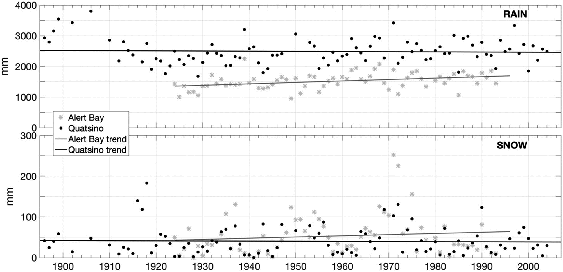
Using the available historical science record, Fig. 2 shows precipitation in the form of rainfall and snowfall at two nearby locations: Alert Bay (1925–1993) and Quatsino(1895–2004), British Columbia. We have chosen to look at the precipitation and temperature records from Quatsino, approximately 70 km east–southeast from Alert Bay across northern Vancouver Island, because this is the only weather record set within 100 km that spans the century of interest, dating back to 1895. Convergent with the Elders’ observations, data from the provincial government indicate that both snow depth and water content have decreased in several of the southern interior ecoregions and in the Georgia Depression ecoregion; however, the ecoregion spanning the entire mountainous British Columbia coast showed no significant trend (British Columbia Ministry of Environment 2016).
Fig. 2.
The Second World War (1939–1945) increased the demand for canned salmon from British Columbia, which can be seen in 1939 BC salmon exports totalling 575 198 cases. On the forestry side the 1940s saw the advent of timber transport using truck logging (McGillivray 2000). By 1940, 18 000 000 m3 of timber were being harvested from private land in British Columbia (McGillivray 2000). In fisheries, in 1945 the Sloan Commission on maximum sustainable yield began (McGillivray 2000). Henry S. Beans remembers the decade as one of cold winters:
“1947, 1946, it used to get pretty cold. And the snow… What I can remember is like two or three feet up from the ground and for months! And there’s a pond up on the top of this island that we used to go ice skating and we used to get tired of ice skating… And now, today, it very seldom freezes up. It doesn’t freeze up. So we don’t get that cold. That’s what I’ve noticed.”
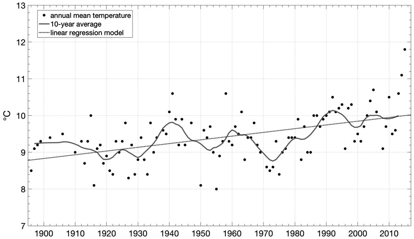
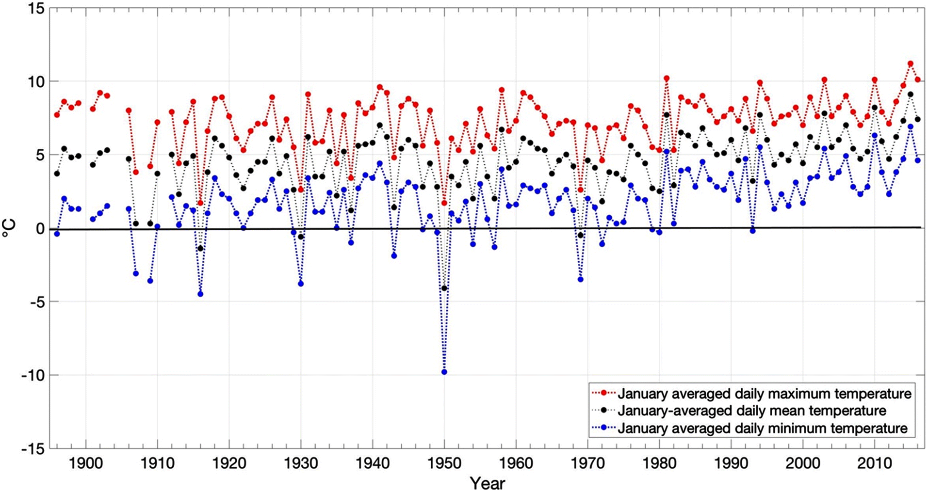
Figure 3 shows annually averaged daily mean temperatures at Quatsino, British Columbia (Vincent et al. 2020). Using a linear least-squares fit of the data, the temperature trend between 1900 and 2016 describes an increase of 0.1 °C per decade (coefficient of determination (R2) of 0.3); between 1970 and 2016 the trend is 0.4 °C per decade (R2 of 0.5), or an approximate 1.8 °C change in annual mean temperature over that period. The 10 coldest years in this record all occur before 1976. Seven of the 10 hottest years all occur after 2004.
Fig. 3.
The twilight of the salmon cannery business came in 1948 when canned salmon markets collapsed in the United Kingdom. Social progress happened in 1949 when all status First Nations peoples were allowed to vote. Following that, in 1951 the Potlatch ban was repealed. Ecosystem changes in the ocean during this time were observed by Alfred “Baker” Coon:
“What they call dolphins. Or porpoise. In the 1950s I never used to see them. 1950s and 1960s…because the change of the water temperature and things like that from the ocean. Years ago they never used to see mud sharks.9 They came in the 1950s–1960s.”
Brian Wadhams also considered this decade as a baseline of dolphin10 numbers:
“Past few years I’ve noticed five six hundred dolphins at a time, that I’ve never seen before. I’ve seen a lot of porpoises, but not dolphins, the little brown ones. It’s strange. That’s what I mean by different little species that never used to travel here (in 1950s). Porpoises used to be the only one we had, not dolphins.”
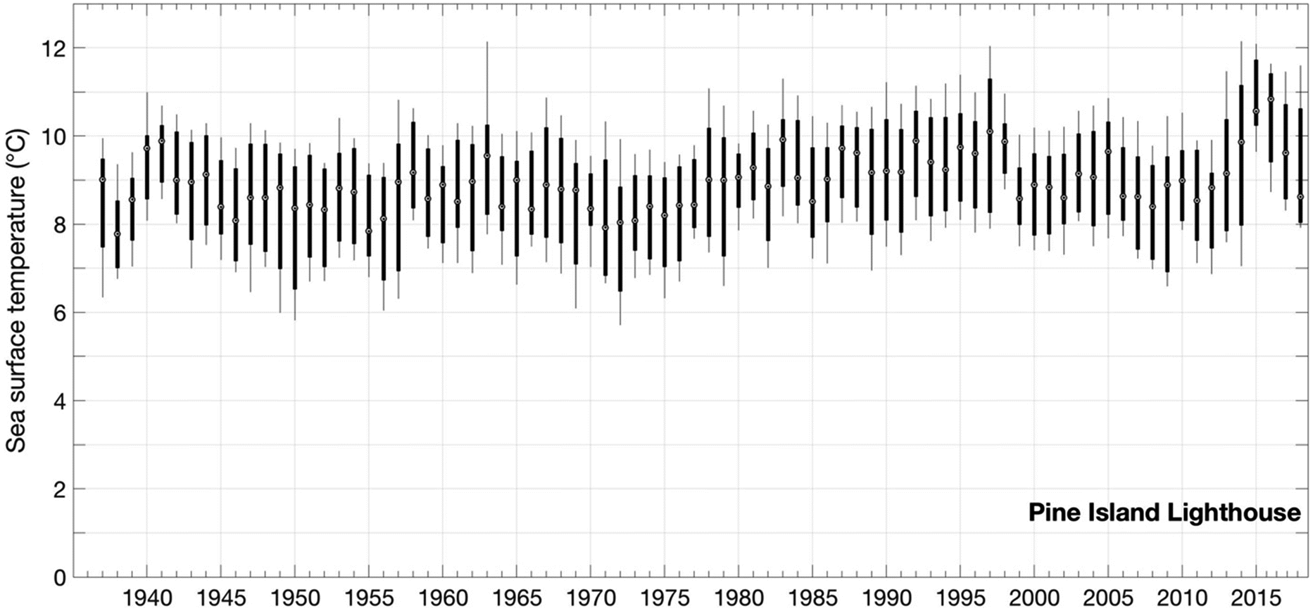
Sea surface temperatures (SST) from Fisheries and Oceans Canada confirm the trend in the warming ocean, as shown in Fig. 4. Over this time period, annually averaged SST measured at Pine Island lighthouse increased by nearly 1 °C. This increase is most significant in spring (increase of more than 1 °C) and summer (1 °C) (British Columbia Ministry of Environment 2016).
Fig. 4.
Alfred “Baker” Coon recalls that the 1950s and 1960s were excellent fishing decades in the commercial harvests around Northern Vancouver Island, a situation that has since collapsed:
“There’s nothing there to fish for. It’s pretty well gone. There was a decline. In the 1950s and 1960s there were so much fish. We used to have six or seven days open. But today we don’t have that. See, it’s a certain owner. A company has control…They control the DFO [Fisheries and Oceans Canada] to say when to open and when to close. And the prices. There’s competition between the wild salmon and the Atlantic salmon (farmed). See right now, there’s a lot of sockeye and we have a better chance. The Atlantic salmon, they compete with the wild salmon.”
The 1950s saw many developments in forestry that affected the terrestrial ecosystems, freshwater, and connections to the ocean and migratory fish according to the Elders. In 1951 new pulp mills were founded in Port Alberni, British Columbia (McGillivray 2000). Lumber trade in the province soared in 1955 with the public timber harvest on Crown lands (this bypassed the private supply of 20 000 000 m3 (McGillivray 2000)). Private land harvests began to decrease. Starting in the late 1960s the residential schools began to be phased out.
These decades are reflected in one of the oral history sessions with Brian Wadhams who discussed the changes in Kingcome and Knight Inlets between 1956 and 1967, with eulachon as a keystone species:
“I used to go up to Knights Inlet every year when I was a kid, from four years old to fifteen, on an Easter break, and that’s when the eulachon would be there. Now (2003) it’s going to April and middle April before they come in now, so it’s well over a month’s change.”
Alfred “Baker” Coon echoed these observations and changes:
“In the 1950s and 1960s we used to hunt seals to eat…but the change in the climate…what they eat because of the fish farms. Seems like it. And sea lions. When we used to have lots of eulachon in Kingcome the sea lions came up to the… But you hardly see that anymore.”
Webster (2001) reported that the “last” proper eulachon run she saw was in 1976 and pointed to the presence of chemicals and ecosystem degradation for these declines.
Alfred “Baker” Coon often cited this decade of the 1950s as the time of cold temperatures and healthy glaciers in his Kwakwaka’wakw home area:
“In the early 1950s and 1960s we used to have a lot of snow. But it has really changed. What I’ve noticed now here is that Kingcome has changed big time. In the early 1950s and 1960s the water body used to be so clear. But now you see the glacier, it’s melting so fast.”
Henry S. Beans has a very clear marker year in this time, 1964, to which present change is contextualized:
“We seem to be losing some of our glaciers up in Knights Inlet. We go to Knights Inlet almost every year and in 1964 we went up, up to where the glacier is and we could see it from the river. And now three years ago (1999–2000), my brother went up there and it’s two mountains back! That glacier that we used to see from the river, it has melted that much.”
Provincial government data confirm this drastic retreat of glaciers across British Columbia. In the Georgia Depression ecoregion (lands surrounding Georgia Strait including southeastern Victoria Island), there was a 34% loss in glacier area between 1985 and 2005. The largest rate of loss occurred in the ecoprovince encompassing the coastal British Columbia mountains (including the Kingcome glacier and Knight Inlet), with an estimated loss of 15.4 km3 per year from 1985 to 2000. This region saw a 6.4% loss of total glacial ice area during that time period. (British Columbia Ministry of Environment 2016).
Several Elders have observed an overall change in winters and interconnected issues:
“I’ve noticed it’s getting warmer and warmer and the winters are getting wetter and wetter. Less snow than when I was a kid in the 50s. Middle fifties we had three-four feet of snow here in Alert Bay. Every winter, and it lasted the end of April. Not anymore, now we get a sprinkling.”—Eddie MacDougall“I’ve witnessed changes in the wintertime. Back when I was a young fellow I used to be able to walk around in three of four feet of snow in the wintertime. Today you’re lucky to see a snowfall. So, those are the kind of changes I’ve witnessed. Well, it comes every year, but you know just in sprinkles, not the way it used to. It used to stay for weeks, now we’re lucky if it stays for a day. That’s’ one of the things I see a change. We don’t seem to get pretty good winters now, especially this year (2003).”—Brian Wadhams (Supplementary material, item BW5)
January average daily maximum, minimum, and mean temperatures at this location are shown in Fig. 5 (Vincent et al. 2020). According to these data, prior to 1980, at least one January per decade had a monthly averaged daily minimum temperature below 0 °C. Between 1980 and 2016, the January monthly averaged daily minimum temperature only fell below freezing only once.
Fig. 5.
In 1968, the Davis Plan reduced the commercial fishing fleet considerably (6104 vessels in 1969, 4707 in 1980) considerably (Richmond et al. 2005). Henry (Hank) J. Nelson remembered this era, prior to the Davis Plan, clearly as a “bonanza” for the commercial salmon fishery:
“I did some, mostly salmon, gillnet fishing, up in Rivers Inlet area before the sharp decline. The fish up there was abundant, in the '64, '68 and it used to be thousands of gillnetters out there. It looked like a city out there at night when they are fishing. And now you can’t even fish up there, there’s no more sockeye salmon. It went from millions down to, they are lucky to get maybe 4000—5000 there.”
Roy Cranmer positioned the changes in the coastal river systems between 1967 and 2003 as one of the drivers of the loss of abundance of salmon:
“We had 188 rivers and streams in the mainland that used to produce some kind of fish when I started skippering a boat, that would be in the 1967. Out of those 188 we could only fish probably about fifteen of those, fifteen of those systems. And since then probably in the late 70s there’s four of those systems that don’t produce anything at all now. Nothing. And the only rivers that produce any fish in there now are the Kingcome Inlet system… There are three systems where we’re fishing now, out of 188. That directly had everything to do with logging.”
The 1960s saw many critically important Indigenous-related policies emerging. First, a 1969 White Paper by the Government of Canada advocated further cultural assimilation of First Nations into the body politic. This led to widespread activation of Indigenous Rights in the province. Secondly, in the lumber trade, by 1970 the public timber harvest was at 40 000 000 m3(McGillivray 2000). In the 1970s, the fish trade continued to transform with smoked salmon emerging as a key commercial product in the region (McGillivray 2000). Roy Cranmer recalled these years:
“Since probably the 70s when fishing started going downhill we find very few young guys now wanting to go fishing because they’ve seen what’s gonna happen. They’re not gonna make any money now. I think our biggest season was about 40 000 dollars.”
In 1973 came the Calder Case Supreme Court Decision that recognized the existence of Aboriginal Title in British Columbia (Calder v British Columbia (AG) 1973). Meanwhile, on the community level, changes continued. Henry S. Beans reflected on the loss of Pacific Cod (Gadus macrocephalus):
“I think we’ve lost quite a bit of our cod through commercial cod fishing here. And… we don’t have very much left of cod. I used to be able to go to the next island here and go and get three or four for my meal. Now, I can’t get it anymore. So yes, we’ve lost some of our cod.”
Pacific cod proliferated strongly between the late 1970s (1000 tonnes harvested peryear in United States waters) and 1995 (430 000 tonnes harvested in United States waters). In more recent years, the species has undergone significant changes throughout its range. For example, in the Gulf of Alaska, Pacific cod experienced elevated mortality after extremely warm ocean conditions led to increased metabolic demands that exceeded energetic consumption, i.e., mass starvation (Barbeaux et al. 2017; Spies et al. 2019). Historically low numbers in the Gulf of Alaska caused the United States federal cod fishery to close for the 2020 season, for the first time, as a result of climate changes (George 2019).
Canada (along with the bordering United States) continued their struggles for salmon management. In 1977 Canadian national marine limits extended to 322 km off the coast, affecting salmon management in the ocean. On land, the lumber industry was reformed; in 1978 old timber licensed and harvested reverted back to the Crown and the forests were reorganized into 36 management regions (McGillivray 2000). In the early 1980s the proliferation of the feller-buncher in forestry (McGillivray 2000) enhanced the immediate efficiency of logging, leading to levels of public timber harvest in 1980 at 60 000 000 m3 (McGillivray 2000). Turner (2005) documented many ‘Namgis concerns where the timber cuts and losses are seen as the worst imposed change.
For both salmon stocks and the Kwakwaka’wakw communities, a system change was around the corner. In 1981 the Pearse Commission (Royal Commission on Forest Resources) addressed the losses of wild salmon stocks, and referred to an increase in salmon farming in British Columbia (see also McGillivray 2000).
“My opinion is that they shouldn’t have even have started it [fish farming]. But we could see where that was going in 1960s. When my father, before he was gone, and one of our elders, before he passed on, he predicted that the fish farms that hit here, that was the end of the commercial fishing. Because that’s not for us, it’s for three or four generations down the road. That’s the way I look at it. The government doesn’t want our wild fish. To me, there’s no more wild fish, they’ve got the farm fish all established, dam the rivers and sell the hydro and sell it to America.”—Eddie McDougall
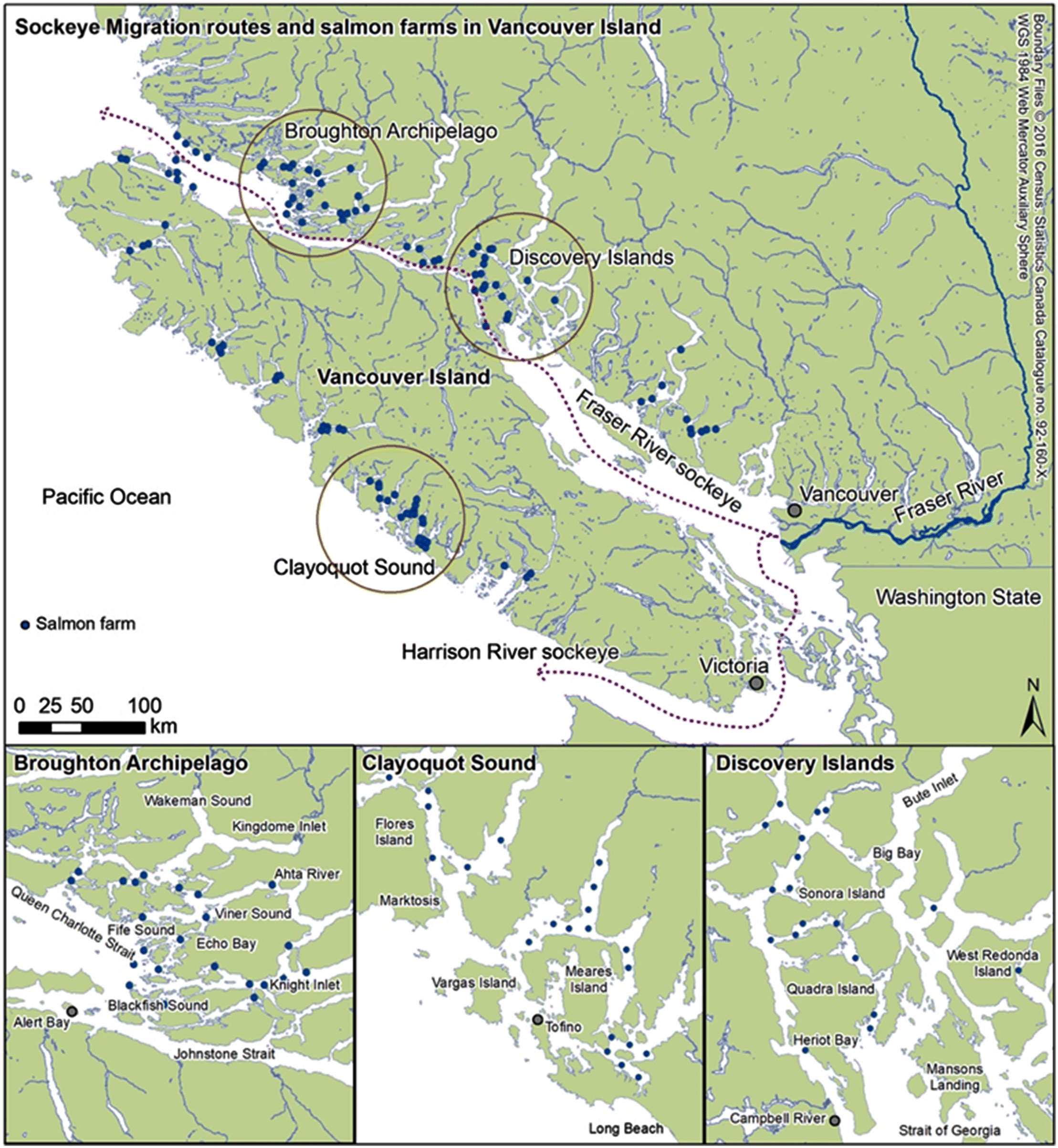
Richmond et al. (2005) contextualized the arrival of the salmon farms as a continuation of the colonial process against the Kwakwaka’wakw nations. Figure 6 provides a sense of the scale of the salmon farms as they exist presently.
“But when a fish farm first came…that’s when everything changed.”—Alfred “Baker” Coon (Supplementary material, item AC2)
Fig. 6.
In our oral history corpus, Brian Wadhams and Henry S. Beans also reported the impacts of salmon farms to the clam beds. Chas Coon summarized: “They are all muddy now. The beaches.” Douglas Scow concurred in his assessment:
“They are just killing all the clams and they just turn to dead beaches. This fish farm when it’s bugging up our territory. Actually I got…when I was walking on that beach that used to be the number one clam beach. Big beach! And it was just like quick sand! The mud just came up to your boots. And it was very stinky.”
Damage to the clam beds and shores represents two levels of impacts for the Kwakwaka’wakw. First, it affects food security and cultural food systems. Secondly, as literature shows, it was the clam beds that constituted a key zone of Indigenous resource management at the individual nation and family levels. By affecting that the pollution also hit hard at the core of the cultural knowledge of the Kwakwaka’wakw (Turner 2005; Deur et al. 2015; Mathews and Turner 2017; Dick et al., In press).
An oral history by Brian Wadhams may summarize best the First Nations’ view of the salmon farms as seen from their internal positioning:
“We continue as human beings [to] tamper with nature. We can’t kill this, we’ve gotta kill those. There’s no balance left. Nature has its way to take care of itself, and we’re really interfering. Somewhere along the line the government is decided that God has made a big mistake and they’re going to correct it. That frightens me. Farm fishing industry. The impacts that is having, when you talk about impacts to salmon. We’ve got the sea lice problems going on in the Broughton Archipelago, we’ve got IHN [infectious haematopoietic necrosis virus] breakouts that are going on in the Broughton Archipelago… But the only time, it stays dormant before they get into rivers and streams, and when they’re under stress and overpopulated, that’s when the outbreak occurs. Now the farm fishing industry has turned IHN into a saltwater disease, which never happened before. … So there’s 1.2 million fish in each little area out there now. And one of the things that really concerns me is that like we talked about nature and it taking care of itself, the sea lice, when fish go up to the river, the sea lice die off, because that’s the way nature takes care of itself. The fresh water kills them off. So what happens now, the fish farming industry has come in, they’re 365 days of the year. … One of the things that really needs to be discovered and really needs to be understood is local knowledge and what it means and how it can help in their science work, that’s really important to understand. So many talented people who understand just the basics of nature. Like I said, I’ve been around this territory all my life, and it takes just common sense to understand nature and how it works.”
Morton et al. (2004), Krkosek et al. (2006, 2007), and Bateman et al. (2016) confirmed the observations and knowledge regarding sea lice infections in the area following salmon farm establishment and their severity to the overall ecology and specifically to wild salmon numbers, health, and survival.
During the 18 years of collaboration with these Elders and the First Nations, the opposition to the salmon farms has been almost uniform.
“Since they brought the Atlantic salmon, and you know brown trout they used to call it… There’s not a chance. They haven’t got a chance because they won’t listen to anything and now that fishing is unpredictable. You know. They are going to bring 40 000 fish to this pond and 50 000 to that pond (fish farm).”—Edgar Lansdowne“I keep coming back to these fish farms! I guess the biggest change that I’m gonna see is that if we never see another wild salmon in the mainland. And that’s all from what’s happening over those fish farms. And another thing is the eulachons, which is a big part of our life and the making of the grease. If somehow those things are gonna be impacted from those fish farms, it’s going to be a big change for a lot of us. Basically, everything that they told us in the beginning back in the 80s has happened.”—Roy Cranmer
In 1985 the public timber harvest (on Crown lands) peaked at 70 000 000 m3 (McGillivray 2000). Henry (Hank) J. Nelson, 2005 linked the massive amounts of harvested timber with weather and water changes:
“The predictability of the weather isn’t the way it used to be. It changes really fast in some cases. And the winds seem to be getting lot stronger and flooding occurs a lot faster than it used to take, and that may be [at]tributed to the forest…lack of forest we have now, for the flooding in rivers. You know this rainfall that happens now, it’s just so fierce, you’ve got that lack of trees to hold back water now. It’s just, lot of damage, erosion…”
A recent paradigm shift in the understanding of the connection between forest removal and flooding in the scientific literature shows agreement with Nelson’s understanding. For example, Green and Alila (2012) showed that in seasonally snow-covered regions, deforestation (at even moderate levels of 30%–40%) lead to both more frequent and, on average, larger seasonal floods.
The end of the 1980s and early 1990s brought again a number of changes in the timber trade. In 1988 the time to license public forest timber sales on Crown lands was reduced making the process faster which fostered accelerating harvests (McGillivray 2000). On the other hand, in 1991 the Province of British Columbia recognized Aboriginal title. The Sparrow 1991 decision on Aboriginal rights confirmed some rights to salmon fisheries also. The Council on Resources and Environment was established in 1991 to increase the protected areas in British Columbia (McGillivray 2000). U’mista Cultural Centre had been established at Alert Bay in the 1980s and several masks and regalia that had been confiscated during the Potlatch ban were returned to the community (Newell and Schreiber 2007; see umista.ca/pages/collection-history).
Many of these corrective and sometimes counterproductive (in the context of actually increasing and speeding up the use of natural resources uses) policies and legal steps changed little in terms of the impacts to the environment on the ground, as Brian Wadhams observed:
“I see the changes in the valley. I worked in the Nimpkish valley for five years as a fisheries guardian for the Department of Fisheries and I see the changes there in the river. You know the water flow temperatures in the summer just drop right off, not the way it used to be when I was a kid. We had a constant flow, steady temperatures. That’s a really big change when it comes to climate.”
In 1994 the provincial Forestry Practices Code was adopted. Alfred “Baker” Coon and Roy Crammer felt that this came too little and too late for the health of the environment and interconnected changes:
“Everything’s being wiped out. And the clams and the salmon. Because of massive floods, there has been raining and it takes out the spawning bay. And the eulachon. You don’t know what is going to happen because of the climate change, too, I think.”—Alfred “Baker” Coon“When they logged this end of the island off (Cormorant Island), we really noticed the wind coming here now. And when they logged the side of that side hill there where it’s all logged off, I mean that made a big difference in the wind here, especially when it’s blowing south-east it seems to blow bit more for some reason.”—Roy Cranmer
In 1995 another round of fisheries reorganization was made with the Mifflin Plan that eliminated many fishing vessels on the coast (Richmond et al. 2005). This also affected the Kwakwaka’wakw knowledge transfer (Supplementary material, item HB1).
“The reason why is that when Mifflin Plan came into place eight years ago, you know they told us, the government came and told us that they would cut the fleet in half and it would give you more fishing opportunity. And what happened there was that they cut the fleet in half and gave us no time whatsoever.”—Brian Wadhams
The mid to late 1990s changed the questions of Indigenous Rights somewhat, with among other developments, the enactment of the British Columbian Treaty Commission and the 1997 Delgamuukw Supreme Court decision on oral histories as valid evidence in land claims cases. However, changes on the ground were slow to realize according to Alfred “Baker” Coon:
“Because of the logging practises. See after the fact…the, our First Nation Kingcome, I didn’t have power to do a thing, no control. It was the provincial government. To oversee what was really happening. But nobody was there to monitor it. That’s why we have a big problem. And Wakeman Sound and Kingcome and Knights Inlet.”
In these years, the Kwakwaka’wakw were by no means passive bystanders on the salmon monitoring and issues. Henry (Hank) J. Nelson explained how the community observed changes in interlinked species, and in salmon between their home area and salmon stocks in the Fraser system, and how they brought these observations (with little notice) to the fisheries departments (Supplementary material, item HN).
The logging rates in 1990s triggered a rather unified range of Kwakwaka’wakw observations from the Elders on the worsening link between timber harvests, river changes and salmon survival.
“There are some guys that blame the logged valley up there, they logged it all out. And it damages the river I guess. In the wintertime, years back, as I remember, the river used to go down nice and clear. But today, now it just stays multi- and muddy-coloured.”—Douglas Scow“In the mainland because of logging practices there have been a lot of, lots of rain and one night rains. It comes to ten feet (300 cm). And we used to have lots of frogs. That’s gone. Because of the climate. And the beavers, that’s gone too. What’s happening in Kingcome and the way we saw it… The grizzlies and the black bears are moving to the reserve. Because of the logging practices. So they go further down…no place to go. And the deer and the wolf—they are almost extinct because of the logging practices.”—Alfred “Baker” Coon
Brian Wadhams had been diving the central river, the Nimpkish, for years to detect the changes on the river, salmon, and loading:
“A lot of erosion. I worked there for five years as a fisheries guardian and that was one of the things I did up in the Nimpkish Valley there, I swam down all the rivers and streams, basically three or four months in a year on a daily basis to see the logging that is having a real impact on the riverbanks.”—Brian Wadhams (Supplementary material, item BW6)
Not only salmon was being affected; impacts to eulachon and to the culture emerged from the oral histories.
“Once we go up to Knights Inlet in the spring, the eulachons… We aren’t getting as much as we used to before. And that comes back to what I was telling to you about the no logs in the river side anymore and it all goes down… And sometimes the river will be four feet high and it usually is for the eulachon to go up… And muddy. That would affect, that’s the effect I see today. And in the earlier times we used to go up there, there was quite a bit of eulachons there before. Now it’s just a fraction of what it used to be.”—Henry S. Beans“When I was a little boy, in Kingcome, during the oolichan [eulachon] time, we could walk down to the beach and we’d be able just to grab oolichans that had spawned just from the shoreline, but you can’t see that nowadays. There’s just not that abundance.”—Henry (Hank) J. Nelson
Coinciding with the changes to the salmon stocks, changes in ocean conditions, with new species arrivals, and changes in behaviour of marine mammals emerged from the observations.
“I’ve noticed a lot of red tide. I don’t know what that could be from, I don’t know if that’s got to do with the climate change. We’ve seen some strange fish, that are not from here. Sunfish. In the past we’ve caught sunfish in a commercial fishery. There’s some changes, like that, you know before you’d never see that around when I was younger. We caught one, it must have been ton. You know, that’s a change.”—Brian Wadhams (Supplementary material, item BW7)“Last few years I was fishing I noticed a lot of porpoises, you know in hundreds travelling in the inlets, even down Johnson Strait, that I’ve never used to observe before as a fisherman. And then we started to notice sunfish, you know different types of, looks like tropical fish, in the nets sometimes.”—Henry (Hank) J. Nelson
Common mola, or sunfish (Mola mola) can weigh 1000 kg and mostly occupy tropical to temperate oceans. It has been often reported off the coast of British Columbia (inaturalist.org/taxa/49601-Mola-mola; Lamb and Edgell 2010). Deur et al. (2015) confirmed the presence of red tide events in the region.
To get a sense of the 1990–2010 levels of salmon harvesting and closure to the century of changes in the Kwakwaka’wakw space, Vodden et al. (2006) reported that approximately 40 000 salmon were distributed throughout the community in 2006, doubling the amount of food fish provided in 2005 due to strong Fraser River returns and the ‘Namgis food fish distribution system.
2010–2012: the flood and the aftermath
The century under view here came to a head on 24 September 2010 (Public Safety Canada 2010; Times Colonist 2010; Globe and Mail 2010). Dzawada’enuxw First Nation was hit heavily by a massive flood. Public Safety Canada (2010) classified the event as a meteorological–hydrological flood. Dawson (2010) and many other Kwakwaka’wakw considered the flood to be unprecedented, and linked the timber harvesting with the behaviour of the Kingcome River waters in the heavy rains.
All the issues of the centennial view—from timber harvests, to climate change and glacier retreat observed years before, to massive rains and subsequent floods and impacts to fish, people, and the environment—culminated in the events of September 2010.11
Our attempt is not to recount or reproduce the impacts of the flood event here. Rather, it is important to witness, through the spirit and intent of the Potlatch system, how the Kwakwaka’wakw in Alert Bay and the Dzawada’enuxw came to terms with this system-level impact.
Chief Edwin Newman and many of the ‘Namgis hosted the evacuated Dzawada’enuxw families and people in the Alert Bay Bighouse in a Potlatch in October 2010 (Mustonen 2010, see also Fazakas 2019). During the three days of potlatching, using songs, storytelling, dances, mask displays, and reaffirmations of tribal loyalties between the ‘Namgis and Dzawada’enuxw, the hosts attempted to alleviate the pain and impacts of the flood. The narratives and recounting of impacts from the floods entered the Big House floor only on the second day and in the speed and manner appropriate to the Kwakwaka’wakw.
In September 2012, the Dzawada’enuxw thanked the ‘Namgis and people of Alert Bay in a responding Potlatch (Blackburn 2013). The village had been rebuilt and the recovery in physical terms had been completed. Blackburn (2013) reports that the Potlatch held in September 2012 addressed the help and support given by the ‘Namgis in 2010.
As Huntington et al. (2017) pointed out, the Indigenous communities have their own agency and spatial, temporal, and cultural response spaces (Turner and Turner 2008; Fazakas 2019). The Potlatches of 2010 and 2012 between ‘Namgis and Dzawada’enuxw show us how the Kwakwaka’wakw peoples affected firstly survived the catastrophe, secondly addressed and recorded it from their own internal Indigenous governance and viewpoints across nations, and thirdly came to terms with the event through the Potlatch feasts (Fazakas 2019).
Thus the flood event of 2010, resulting from the simultaneous and coinciding drivers affecting the Kwakwaka’wakw home area, became a symbol of the century of changes and their consequences, but at the same time demonstrated how these nations could still come to terms with the events at least socially and culturally, when the need arose.
8
Central to the study here, also in sectoral and administrational terms, is that the forestry actions (and subsequent timber licenses, Turner 2005) are controlled and managed by the British Columbian provincial government.
9
Comparing scientific view of the “mud shark”, Ketchen (1986) discussed the stocks of Squalus acanthias off the coast of Vancouver Island and in the inland straits. He said that the species have been highly migratory (even between the northern British Columbia coast and California), which may be a reason for the “appearance” or perceived abundance observed in 1950s–1960s. He also confirmed a north–south seasonal migration. Ketchen (1986) confirmed some archaeological findings from prehistoric sites in the Kwakwaka’wakw home area so the species may not be totally unknown historically. His data point to low numbers of Squalus acanthias in fishery catch records from the region pre-1950s. Alternatively, Ketchen (1986) noted that the federal government had a stimulus programme for the harvesting of Squalus acanthias in other parts of the coast, so the observation may be related to the increased (and supported) fishing effort.
10
Possibly referring to short-beaked common dolphin (Delphinus delphis) or Long-beaked common dolphin (Delphinus capensis)
11
Chief Bob Chamberlin, Musgamagw-Tswataineuk Tribal Council chairman, summarized this when he said at the time: “The provincial government has enjoyed unlimited revenue from this place with no return to the First Nation that holds title. I think that would be an interesting conversation.” (Ancient Forest Alliance, 2010)
Discussion
Between the late 1700s and 2010 the Kwakwaka’wakw peoples included in the geographical scope of this paper saw their world turned upside down both in literal terms (loss of biodiversity, land, forests, and changes to the oceans) and in social terms (sustained attack on their key institutions, loss of life from pandemic and other ills, and a new life without rights in their home area) (Turner and Turner 2008).
One of the key results emerging from the oral history materials is the concept of interconnectedness and interconnected processes. Sectoral management, governance, and responses from governmental agencies based on sectoral scientific data are not often able to tackle system-spanning drivers such as changes involving ocean and rainforest boundaries, multiple simultaneous impacts from climate change or extreme events and, lastly, the ramifications and cascading and lingering impacts of such changes in the socio-ecological systems of the coast.
This becomes very evident in the oral history by Henry S. Beans (Supplementary material, item HB2) from 2003:
“It’s difficult for the salmon itself. Because sometimes there’s not enough water in the river to go up. Or the water in the river is too warm and they can’t go up. They don’t go up…certain temperature when they do go up. And sometimes, if it’s too warm too long, they just die at the mouth of the river instead of spawning. But that’s one of the effects warm weather has. And we don’t get that much…what keeps…in the water because there are no more glaciers. And with all the logging, on the river, every time it rains it just floods through, the river.”
Solutions that arise from the work in this paper point to a number of reforms other authors have deduced as well (for example, Turner and Turner 2008; Weatherdon et al. 2016). The most relevant three that we can summarize from this collective century of Elders’ knowledge include:
1.
Indigenous- led monitoring and consented sharing of observations tied with a response network are critical to come to terms with, react to, and plan for major changes under way. This is indicated by the survival of Indigenous Kwakwaka’wakw knowledge systems and ways of knowing that have enabled these Elders to come to independent analysis of interconnected changes, linking for example salmon and ocean health with river and forest ecosystem functioning.
2.
The recognition of Indigenous land rights should remain a high priority. Given the system level impacts of climate change in the oceanic and coastal environments of the Kwakwaka’wakw home area, the very basic governance and stability of the land and coastal ownership and title should be solved; especially in the wake of the Province of British Columbia’s decision to ratify the United Nations Declaration of Indigenous Peoples (UNDRIP).
3.
Fostering endemic response spaces for the multiple changes under way. What means, resources, and rights do communities have to respond to change on their own terms? This solution incorporates mechanisms to strengthen Indigenous linguistic and cultural knowledge, rebuilding and revitalizing, as well as fostering and supporting, where applicable, ocean- and land-based food security systems (fisheries, gathering economies, seal harvests, etc.), including the ability to manage plant and animal populations and habitats.
Conclusions
This paper explored a rigorous set of data from scientific research alongside orally shared observations and histories spanning a century of experiences about overall change, and specific elements and drivers of change, in the Kwakwaka’wakw home area. Given the dynamic nature of the coastal environment of the Kwakwaka’wakw territory, change has come in many forms in the natural systems on which the people rely.
Observations, wisdom, and knowledge of Elders spanning decades, over the course of a full century, provide depth, variation, detail, and complexity that is often missing from science observations. It is very exact, local, place-based knowledge that also holds the capacity to deduct meaning and significance across ecosystems and scales in an interconnected whole. Whilst primary data (temperature, weather records, etc) may exist from the corresponding era, the interpretation and contextualization of significance, meaning, severity, and interconnectedness of change may be missed. When policy decisions are made on the basis of data from scientific research and short-term economic considerations alone, they can be flawed and ineffective.
The applicability of the “slow view” of the 2010 and 2012 Potlatches as mechanisms to come to terms, socially and communally, with the devastations of the flood of 2010 in the Dzawada’enuxw area in Kingcome is of utmost importance. This example fulfills the critically important markers of what Huntington et al. (2017) called an autonomous response space.
The implications of this long, Indigenous-led cultural process, taking years to come to terms with major events affecting the lands, rivers, and Kwakwaka’wakw life, demonstrates the major difference between the Indigenous-instigated mechanisms and the “quick fix” of emergency responses of the society at large, which lacks the tools to come to terms with the meaning and layered devastation of such events.
In the past, if a divergence happened between scientific observations and Indigenous knowledge, scientific deduction and interpretation prevailed. This choice was often made from a position of power, and Kwakwaka’wakw knowledge of issues or observations was seen as inferior or irrelevant.
Today, a sufficient body of Kwakwaka’wakw knowledge and academic literature has suggested that divergence needs to be documented, researched and, ultimately, learned from. Similarly, areas of convergence between different views must be respected and understood as powerful. In the analysis above, strong convergence was evident between climactic observations and Kwakwaka’wakw knowledge shared by the Elders.
The limited amount of scientific data available on many species and interconnected ecological themes over this time period of 100 years makes deeper analysis from the scientific view challenging or nonexistent. The Elders’ knowledge spanning interconnected issues and events is critical over that century. As Deur et al. (2015) and Turner and Turner (2008) demonstrated, what appeared to the early European explorers and subsequent arriving peoples as an “untouched wilderness” coast of the Kwakwaka’wakw homelands was indeed a carefully managed, productive landscape under the careful stewardship of Indigenous governance.
Vodden et al. (2006, p. 4) quoted a workshop participant who said: “They call us the Kwakwaka’wakw people, the Kwak’wala speaking people. What would we be as a people without our language? The language is the spirit of the people, it comes from the land, and it is dying.” Turner and Turner (2008) summarized the whole transformative period as loss of Indigenous knowledge and traditional foods through loss of access, changes in habitats over century, and pollution.
“I’ve been fighting them for so long now, I’m trying to ensure that the commercial fishery will always be there. When we talk about our traditional way of life, that’s part of it, it’s not just commercial fishing, it’s gonna effect the gathering of the wild stocks. Logging, ozone layer, the pulp mills, the ozone layer is getting smaller and smaller. That’s what frightens me, that sometimes we value dollars over the environment, and the species that we have in it.”—Brian Wadhams (Supplementary material, item BW8)It hurts me. To see what’s happening to our people here. It’s almost like they’ve pushed us in to a corner and say you stay over there and don’t say anything.—Henry S. Beans (Supplementary material, item HB3)
Vodden et al. (2006) described changes that the ‘Namgis had taken to come to terms with the changing fisheries to date. The community now holds 13 communal licenses, including for dogfish and sardines. Pursuing other licenses such as for crab and prawns is also considered, as well as salmon smoking. An agreement has been negotiated with Fisheries and Oceans Canada for an exclusive ‘Namgis commercial fishery for “excess” Nimpkish chum. Williams (2001) showed how cultural reclaiming (in pictographs) has emerged as a vehicle of Indigenous knowledge-making. Chief Beau Dick (Fazakas 2019) fought the imposition of the environmental and cultural damage using his art and potlatches. Turner and Turner (2008) pointed to the potential of ecosystem restoration as a remedy for many of the ills. Weatherdon et al. (2016) highlighted the opportunity for and benefit of Indigenous knowledge and traditional fisheries management strategies to guide responses to challenges from climate impacts.
Such steps, alongside ongoing talks with the state of Canada on Indigenous Rights, have paved the way to the 2010s and 2020s with many of the key issues continuing from the last century and beyond. The Kwakwaka’wakw, as always, remain centered in their homelands and waters, doing all they can, to maintain the critically important links between humans, nature, fish, and the surrounding webs of life around them.
Acknowledgements
All work was internally funded by the Snowchange Cooperative. Elders who have been involved in this work are as follows. Roy Cranmer is a semi-retired commercial fisherman and he worked as a councillor for the ‘Namgis tribe. He was the band manager in 1969–1972 for the ‘Namgis tribe and his brother, Bill Cranmer, was also the band manager. Edgar Lansdowne was born on 13 May 1917 at the mouth of the Nimpkish River. He worked as a hunter, a logger, a whale-watching guide, and in many other professions. (Deceased.) Harry “Cash” Mountain (1920–2004) was born at Village Island where his family comes from. (Deceased.) Chas Coon, Douglas Scow, and Oxley Alfred (deceased) come from Kingcome. Brian Wadhams is from Turnour Island. He was born in 1952 and he was transferred to the ‘Namgis when he was six–seven years old. He has been a commercial fisherman for 37 years and he works as a band councillor for the ‘Namgis First Nation and as an Outreach Coordinator for the Musgamagw Tsawataineuk Tribal Council. Alfred “Baker” Coon comes from Kingcome Inlet. He works at the Kwakiutl Territorial Fisheries Commission as a fisheries observer. He has been a fisheries observer since 1985 to the present day. He used to be a logger, a welder, and a commercial fisherman. Eddie “Bones” MacDougall is from Alert Bay and he has lived there all his life. He was born in 1949. He started fishing when he was young, five or six years old and he was a commercial fisherman for about 44 years. Henry S. Beans had lived in Alert Bay since 1947. He was from the Mamalilikulla Band from Knight Inlet but they joined the Nimpkish Band in 1947. He was a retired fisherman. (Deceased.) Henry (Hank) J. Nelson is from Kingcome Inlet. He used to be a fisherman, logger, and has been working with the N’amgis First Nations Salmon Enhancement Programme since 1979.
References
Ancient Forest Alliance. 2010. Clearcuts blamed in First Nation flooding [online]: Available from ancientforestalliance.org/clearcuts-blamed-in-first-nation-flooding/
Augerot X. 2005. Atlas of the Pacific Salmon. 1st Edition. University of California Press, Berkeley, California. 161 p.
Barbeaux S, Aydin K, Fissel B, Holsman K, Palsson W, Shotwell K, and Zador S. 2017. Assessment of the Pacific cod stock in the Gulf of Alaska. Stock assessment and fishery evaluation report for the ground-fish resources of the Bering Sea/Aleutian Islands regions [online]: Available from afsc.noaa.gov/REFM/Stocks/assessments.htm
Bateman A, Peacock SJ, Connors B, Polk Z, Berg D, Krkosek M, and Morton A. 2016. Recent failure to control sea louse outbreaks on salmon in broughton archipelago, British Columbia. Canadian Journal of Fisheries and Aquatic Sciences, 73: 1164–1172.
Blackburn M. 2013. Kingcome looks to the future after flood nearly washes out community, APTN News [online]: Available from aptnnews.ca/national-news/kingcome-looks-to-the-future-after-flood-nearly-washes-out-community/
Berkes F. 2018. Sacred Ecology. Routledge, UK. 392 p. ISBN 978-0415517324.
Bouchard R, and Kennedy D. 2006. Indian Myths and Legends From the North Pacific Coast of America: A Translation of Franz Boas’ 1895 Edition of Indianische Sagen von der Nord-Pacifischen Kuste Amerikas. Talon Books, Vancouver, BC. 704 p.
Boyd, R. I. 1994. Smallpox in the Pacific Northwest: The first epidemics. B.C. Studies: A Quarterly Journal of Humanities and Social Sciences, 101: 5–40.
British Columbia Ministry of Environment. 2016. Indicators of climate change for British Columbia: 2016 update. Ministry of Environment, British Columbia, Canada.
Calder v British Columbia (AG). 1973. SCR 313, 4 WWR 1.
Cullon D. 2013. A view from the watchman’s pole: Salmon, animism and the Kwakwaka’Wakw summer ceremonial. BC Studies, 177: 9–37.
Dawson C. 2010. Kingcome inlet flood [online]: Available from youtube.com/watch?v=UP7BdPulOwg
Deur D, Dick A, Recalma-Clutesi K, and Turner NJ. 2015. Kwakwaka’wakw ”Clam Gardens”. Human Ecology, 43: 201–212.
Deur D, and Turner N. 2005. Keeping It Living: Traditions of Plant Use and Cultivation on the Northwest Coast of North America, University of Washington Press, Seattle WA.
Dick A, Sewid-Smith D, Recalma-Clutesi K, Deur D, and Turner NJ. In press. “From the Beginning of Time”: The Colonial Reconfiguration of Native Habitats and Indigenous Resource Practices on the British Columbia Coast. Facets, 7(1).
Eklund H. 2004. Local Observations on Salmon and Environmental Change in Kwakwaka’wakw Territory. Thesis, Tampere Polytechnic.
Fazakas L. 2019. Beau Dick: Devoured by Consumerism. Figure 1 Publishing, Vancouver.
Fisheries and Oceans Canada. 2021. British Columbia Lightstation Sea-Surface Temperature and Salinity Data (Pacific), 1914 – present [online]: Availble from dfo-mpo.gc.ca/science/data-donnees/lightstations-phares/index-eng.html.
Garibaldi A, and Turner NJ. 2004. Cultural keystone species: Implications for ecological conservation and restoration. Ecology and Society, 9: 1.
George K. 2019. Alaska cod fishery closes and industry braces for ripple effect. National public radio [online]: Available from npr.org/2019/12/08/785634169/alaska-cod-fishery-closes-and-industry-braces-for-ripple-effect
Globe and Mail. 2010. Aboriginals displaced by flooding need aid, B.C. First Nations say. [online]: Available from theglobeandmail.com/news/british-columbia/aboriginals-displaced-by-flooding-need-aid-bc-first-nations-say/article1214324/
Green K, and Alila Y. 2012. A paradigm shift in understanding and quantifying the effects of forest harvesting on floods in snow environments. Water Resources Research, 48: W10503.
Helander T, and Mustonen E. 2004. Snowscapes, Dreamscapse: Snowchange Book on Community Voices of Change. Tampere Polytechnic, Finland, 562 pp.
Huntington, H. 2000. Using traditional ecological knowledge in science: Methods and applications. Ecological Applications, 10(5): 1270–1270.
Huntington HP, Begossi A, Fox Gearheard S, Kersey B, Loring PA, Mustonen T, et al. 2017. How small communities respond to environmental change: patterns from tropical to polar ecosystems. Ecology and Society, 22(3): 9.
Jääskeläinen, K. 1907. ‘Elämää Malko-saarella’/Life on Malcolm Island and Sointula, 1907.
Ketchen KS. 1986. The spiny dogfish (Squalus acanthias) in the Northeast Pacific and a history of its utilization. Canadian Special Publication of Fisheries and Aquatic Sciences, 88: 78 p.
Krkosek M, Lewis MA, Morton A, Neil Frazer L, and Volpe JP. 2006. Epizootics of wild fish induced by farm fish. PNAS, 103(42): 15506–15510.
Krkosek M, Ford JS, Morton A, Lele S, Myers RA, and Lewis MA. 2007. Declining wild salmon populations in relation to parasites from farmed salmon. Science, 318(5857): 1772–1775.
Lamb A and Edgell P. 2010. Coastal Fishes of Pacific Northwest. 2nd edition. Harbour Publishing, British Columbia. 352 p.
Macdonald, J. 2000. The Arctic Sky – Inuit Astronomy, Star Lore, and Legend. 1st edition. Nunavut Research Institute. 312 p.
Mathews DL and Turner N. 2017. Ocean cultures: Northwest coast ecosystems and indigenous management systems. In Conservation for the Anthropocene ocean: Interdisciplinary science in support of nature and people. Edited by PS Levin and MR Poe. Academic Press. pp. 169–206.
McGillivray B. 2000. Geography of British Columbia: People and Landscapes in Transition. 1st Edition. University of British Columbia Press. 235 p.
Mekis É and Vincent LA. 2011. An overview of the second generation adjusted daily precipitation dataset for trend analysis in Canada. Atmosphere-Ocean, 49(2): 163–177.
Menzies, C. 2016. People of the Saltwater: An Ethnography of Git lax m’oon. University of Nebraska Press, Lincoln, NE, USA. 198 p. ISBN 978-0-8032-8808-9.
Morton A, Routledge R, Peet C, and Ladwig A. 2004. Sea Lice (Lepeophtheirus salmonis) infection rates on juvenile pink and chum salmon in the nearshore marine environment of British Columbia, Canada. Canadian Journal of Fisheries and Aquatic Sciences, 61(2): 147–157,
Mustonen T. 2003. Snowchange and temporal borders of the indigenous peoples of the north. Unpublished Master Thesis. University of Tampere.
Mustonen T. 2010. Unpublished Notes from a visit to Alert Bay, October 2010.
Mustonen T. 2014. Endemic time-spaces of Finland: Aquatic regimes. Fennia - International Journal of Geography, 192: 120–139.
Mustonen T, Maxwell KH, Mustonen K, Jones R, Pedersen H Nuunoq (Per Ole Fredriksen), et al. 2021. Who Is the Ocean? Reviews in Fish Biology and Fisheries,
Mustonen T, and V. Shadrin. 2021. The river alazeya: Shifting socio-ecological systems connected to a northeastern siberian river, Arctic, 74(1).
Newell D, and Schreiber D. 2007. Collaborations on the periphery: The Wolcott-Sewid Potlatch Controversy. BC Studies, 152.
Public Safety Canada. 2010. [online]: Available from cdd.publicsafety.gc.ca/dtpg-eng.aspx?cultureCode=en-Ca&provinces=1%2C2%2C3%2C4%2C5%2C6%2C7%2C8%2C9%2C10%2C11%2C12%2C13&normalizedCostYear=1&dynamic=false&eventId=1029
Reid M, and Sewid-Smith D. 2004. Paddling to Where I Stand. UBC Press, Vancouver, BC. 342 p.
Richmond C, Elliott SJ, Matthews R, and Elliott B. 2005. The political ecology of health: Perceptions of the environment, economy, health and well-being among ‘Namgis first nation. Health and Place 11: 349–365.
Sanborn, A. 2004. U’mista Cultural Centre. Alert Bay. Personal comment. 9.2.2004.
Schreiber D. 2006. First nations, consultation, and the rule of law: Salmon farming and colonialism in British Columbia. American Indian Culture and Research Journal, 30(4): 19–40,
Sheridan J, and Longboat D. 2006. The Haudenosaunee Imagination and the Ecology of the Sacred, Space and Culture, 9(4): 365–381,
Spies I, Gruenthal K, Drinan D, Hollowed A, Stevenson D, Tarpey C, and Hauser L. 2019. Genetic evidence of a northward range expansion in the eastern Bering Sea stock of Pacific cod. Evolutionary Applications, 13: 362–375.
Times Colonist. 2010. Kingcome rises above waters. [online]: Available from timescolonist.com/kingcome-inlet-rises-above-waters-1.11546
Turner N. 2005. The earth’s blanket: Traditional teachings for sustainable living. Douglas and McIntyre, Vancouver, BC. 304 p.
Turner N and Turner K. 2008. “Where Our Women Used to Get Food” – Cumulative Effects and Loss of Knowledge and Practice, Case Study from Coastal British Columbia. Botany, 86: 103–115.
Turner T, Deur D, and Lepofsky D. 2013. Plant management systems of British Columbia’s first peoples. BC Studies, 179, Autumn 2013.
U’mista Cultural Society. 2021. Living Tradition: The Kwakwaka’wakw Potlatch on the Northwest Coast. [online]: Available from umistapotlatch.ca/potlatch-eng.php
U’mista Cultural Society. 2021. Our Land: Kwakwaka’wakw Territories [online]: Available from umistapotlatch.ca/notre_terre-our_land-eng.php
Vincent LA, Hartwell MM, and Wang SL. 2020. A third generation of homogenized temperature for trend analysis and monitoring changes in Canada’s Climate. Atmosphere-Ocean.
Vodden K., et al. 2006. Community Report - Adapting to Uncertain Futures Workshop [online]: Available from studylib.net/doc/11268832
Weatherdon LV, Ota Y, Jones MC, Close DA, and Cheung WWL. 2016. Projected scenarios for coastal first nations’ fisheries catch potential under climate change: Management challenges and opportunities. PLoS ONE, 11(1): e0145285.
Webster G. 2001. Dzawadi (Eulachon Fishing). Anthropologica, 43(1): 37–41.
Williams J. 2001. Two wolves at the dawn of time: Kingcome inlet pictographs 1893–1998. New Star Books, Vancouver, BC. 248 p.
Supplementary material
Supplementary Material 1 (PDF / 113 KB)
- Download
- 113.50 KB
Information & Authors
Information
Published In
FACETS
Volume 6 • Number 1 • January 2021
Pages: 2110 - 2137
Editor: Nicole L. Klenk
History
Received: 14 July 2021
Accepted: 27 September 2021
Version of record online: 23 December 2021
Notes
This paper is part of a collection titled “Ărramăt, the intersections of biodiversity conservation and Indigenous health and well-being”.
Copyright
© 2021 Mustonen et al. This work is licensed under a Creative Commons Attribution 4.0 International License (CC BY 4.0), which permits unrestricted use, distribution, and reproduction in any medium, provided the original author(s) and source are credited.
Data Availability Statement
All relevant data are within the paper and in the Supplementary Material.
Key Words
Sections
Subjects
Authors
Author Contributions
All conceived and designed the study.
All performed the experiments/collected the data.
All analyzed and interpreted the data.
All contributed resources.
All drafted or revised the manuscript.
Competing Interests
The authors have declared that no competing interests exist.
Metrics & Citations
Metrics
Other Metrics
Citations
Cite As
Tero Mustonen, Brie Van Dam, and Hanna Eklund. 2021. A century of knowledge: Kwakwaka’wakw Elders and environmental change. FACETS.
6(): 2110-2137. https://doi.org/10.1139/facets-2021-0101
Export Citations
If you have the appropriate software installed, you can download article citation data to the citation manager of your choice. Simply select your manager software from the list below and click Download.
Cited by
1. “From the beginning of time”: The colonial reconfiguration of native habitats and Indigenous resource practices on the British Columbia Coast