Complementary responses of stream fish and benthic macroinvertebrate assemblages to environmental drivers in a shale-gas development area
Abstract
Shale-gas production could impact freshwater quality through contamination of the physical and chemical habitat (e.g., fracturing fluids, untreated or treated effluent) or development-related impacts. Despite environmental concerns, information is lacking to support biomonitoring as a diagnostic tool to assess impacts of shale-gas production. We characterized water quality and biota in areas of high shale gas potential (Early Carboniferous bedrock in New Brunswick, Canada) and surrounding geologic areas, and we assessed patterns in benthic macroinvertebrate (BMI) and fish assemblages. Early Carboniferous stations differed primarily based on water chemistry, and BMI were associated with a gradient in conductivity and temperature across geologic classes. Concordance analysis indicated similar classification of stations by both organism groups, though fish were more related to turbidity and nutrients. Concordance among fish and BMI was strongest at high conductivity, Early Carboniferous stations. These results suggest that geology plays a strong role in driving abiotic habitats and biotic communities of streams, even at small spatial scales. Furthermore, they suggest BMI and fish can provide complementary information for biomonitoring in shale-gas development areas, with BMI responding to increased ion concentrations from surface water contamination, and fish responding to changes in nutrients and turbidity resulting from development.
Introduction
Hydraulic fracturing of oil shale deposits (unconventional gas production) offers high potential for the production of natural gas (Rivard et al. 2014), particularly with recent technological advances that have made the fracturing and extraction process more efficient (Vengosh et al. 2013; Vidic et al. 2013; Soeder and Engle 2014). Hydraulic fracturing involves horizontal drilling at depths >1 km into the shale and injection of large volumes of fluids at high pressure (slickwater that is laced with viscosity gels and chemical additives including hydrocarbons) to assist in the recovery of gas (Gregory et al. 2011; Rivard et al. 2014; Soeder and Engle 2014). Environmental concerns related to unconventional gas activities include the potential for groundwater contamination through stray gases or hydraulic connectivity from fracturing activities (Vengosh et al. 2013, 2014; Lavoie et al. 2014), the fragmentation and alteration of habitats as a result of water withdrawal and infrastructure development to support fracturing activities (Entrekin et al. 2011; Brittingham et al. 2014), and the need for safe disposal of the large volumes of recovered fracking fluids, which could cause groundwater and surface water contamination if insufficiently treated or if a spill occurs (Entrekin et al. 2011; Gregory et al. 2011; Warner et al. 2013; Lavoie et al. 2014; Vengosh et al. 2014). Spills of untreated fracking fluids can release high concentrations of salts, organics, and metals into surrounding freshwaters (Vengosh et al. 2014). Furthermore, an analysis of treated wastewater effluent from fracking activities in Pennsylvania indicated that some contamination of surface waters is possible even after treatment if fluids are discharged into nearby streams (Warner et al. 2013). Despite the potential for environmental impacts, there remains a lack of information to support the development of diagnostic tools for environmental monitoring of these activities (Vengosh et al. 2013, 2014; Vidic et al. 2013; Leger et al. 2016a, 2016b), and significant gaps exist in the monitoring of shale-gas production areas (Entrekin et al. 2011; Kinchy et al. 2016).
Shale-gas formations have particular geological characteristics (bedrock age, formation, organic content, and depth) that determine the accessibility of the shale gas and the potential yield (Dyni 2003; Rivard et al. 2014). The geological characteristics that determine suitability for shale-gas development may also play a role in determining physical and chemical characteristics of overlying freshwater habitats. For example, water chemistry composition and substrate bed material of rivers have been shown to vary across geology types (Johnson et al. 1997; Dow et al. 2006). Specifically, Lento et al. (2019) found higher ion concentrations in streams underlain by Early Carboniferous bedrock (a formation with high shale-gas potential) than in surrounding streams. Several studies have noted that the variability in the chemical and physical habitat that is observed in freshwaters with different underlying geology is accompanied by strong differences in biotic communities across these systems, such as differences in species composition and dominant species (Leland and Porter 2000; Esselman et al. 2006; Yates and Bailey 2010), even when geological shifts occur over small spatial areas (Neff and Jackson 2011, 2012). Thus, it may be possible to predict the biota that would be present across natural differences in geology (including areas with and without shale-gas potential) based on known tolerances to the physical and chemical habitat characteristics associated with different types of bedrock geology. However, such prediction would require a better understanding of the characteristics of abiotic habitats and biotic communities found in freshwaters overlying geologic formations with high shale-gas potential. This information is necessary to describe the natural variation that may exist in these areas relative to other (potentially neighbouring) geological formations, but also to improve our ability to predict biotic and abiotic shifts within these systems as development and production increase.
Evaluation of the biotic communities that are characteristic of the chemical and physical habitat conditions of shale-gas-producing geologic areas and monitoring of changes within those areas relative to surrounding geological formations is reliant on the selection of appropriate taxonomic groups, focusing on those that might be expected to respond to the anthropogenic stressors of interest (Hering et al. 2006; Goodsell et al. 2009; Yates and Bailey 2010). In river systems, benthic macroinvertebrates (BMI) and fish are commonly used as bioindicators because they are widespread, easy to sample, and have well-documented tolerances to perturbation (Bonada et al. 2006; Resh 2008). In addition, each group has its own advantages: for example, BMI are relatively immobile and reflect local conditions, whereas fish are long-lived and have social and economic importance (Bonada et al. 2006; Resh 2008). However, each group of organisms also differs in its response to perturbation (Hering et al. 2006; Johnson et al. 2006), with a stronger response of BMI to local water chemistry and substrate size changes and a response of fish to physical habitat shifts, including temperature (Hering et al. 2006; Yates and Bailey 2011; Bae et al. 2014). Selection of suitable indicator groups must involve a detailed evaluation of the response of target groups to relevant anthropogenic stressors (Goodsell et al. 2009; Yates and Bailey 2010). Where the full extent of potential stressors is unknown, the combined assessment of multiple groups may provide the best characterization of baseline conditions and biotic integrity in a system (Bonada et al. 2006; Hering et al. 2006). The use of multiple bioindicator groups in monitoring and assessment assumes that each biotic group has a complementary stressor response, i.e., that each group responds to different stressors, improving the diagnostic capacity of the suite of bioindicators and increasing the likelihood of detecting impacts (Hering et al. 2006).
A measure of similarity might be expected in the characterization of rivers or lakes by different organism groups where there are large-scale environmental drivers acting on those freshwater systems, if all organisms respond in a similar manner (Paavola et al. 2006; Johnson et al. 2007). One way to assess the differences and similarities in the responses of groups of organisms is to evaluate community concordance, which measures the extent to which there is coherence or consistency among biotic assemblages, i.e., similarity in the characterization of stations based on the community structure of different groups of organisms (Jackson and Harvey 1993). Significant levels of community concordance have been found in assessments of BMI, fish, and other freshwater organism groups (e.g., diatoms, bryophytes, plankton, macrophytes) in both lakes and rivers (Kilgour and Barton 1999; Johnson and Hering 2010; Neff and Jackson 2013), though in some cases the strength of concordance was dependent on spatial or temporal scale of assessment (Allen et al. 1999; Heino 2002; Paavola et al. 2006; Bowman et al. 2008). At small spatial scales, researchers have noted a lack of concordance among communities where local-scale drivers dominate and have suggested that each organism group responded to different environmental and anthropogenic pressures (Paavola et al. 2003; Heino et al. 2005; Infante et al. 2009; Larsen et al. 2012). In contrast, the higher concordance among communities at regional scales has been suggested to result from large-scale environmental drivers acting in a similar fashion across broad spatial scales (e.g., Heino 2002; Paavola et al. 2006). If this is the case, then the unique physical and chemical habitat of stream systems in geological areas with shale-gas potential has the potential to drive concordance among stream assemblages, even if there are differing responses of organism groups to localized environmental drivers.
The purpose of this study was to characterize stream fish and BMI assemblage structure in southeastern New Brunswick, Canada, an area underlain by different ages of bedrock (Early-Late Carboniferous and older-age sedimentary and nonsedimentary bedrock), identify dominant drivers for fish and BMI, and assess the level of community concordance among fish and BMI in these systems. Areas underlain by Early Carboniferous bedrock have a high potential for shale-gas extraction, yet characterization of the physical and chemical habitat and biotic communities of freshwaters in these areas has been limited (Kinchy et al. 2016). Therefore, the assessment of biotic and abiotic patterns within these systems and in relation to surrounding geological age classes has the potential to inform management and biomonitoring of freshwater systems in shale-gas development areas. Community concordance among fish and BMI assemblages was predicted to be high if (i) BMI and fish displayed similar patterns because they responded to the same environmental drivers or (ii) geological age class acted as a large-scale driver of community structure, leading to increased concordance among organism groups.
Methods
Study design
Sampling was conducted in the Kennebecasis and Pollett watersheds in southeastern New Brunswick, Canada (Fig. 1). The area is primarily forested, with some agriculture and a small percentage of land cover composed of settlements, infrastructure, and industry, including shale-gas exploration and extraction. Headwater regions of the Kennebecasis and Pollett rivers comprise morainal and colluvial surficial geology deposits, whereas the mid to lower reaches are dominated by morainal, glaciofluvial, and alluvial deposits (Rampton 1984). Bedrock geology in the western part of the study area is characterized by Early Carboniferous sedimentary bedrock (Mississippian era) underlain by the Lower Carboniferous Albert formation, which has potential for conventional natural gas and unconventional (shale gas) extraction (Macauley et al. 1984, 1985; Leblanc et al. 2011). The eastern part of the study area is dominated by Late Carboniferous sedimentary bedrock (Pennsylvanian era), which differs from oil shale bedrock with respect to mineral content and organic composition (Dyni 2003). Older classes of bedrock, including sedimentary Devonian-Carboniferous bedrock and volcanic and intrusive bedrock from the Neoproterozoic era, are found along the southern boundary of the study area (see Lento et al. 2019 for a full description of bedrock geology in the study area).
Fig. 1.
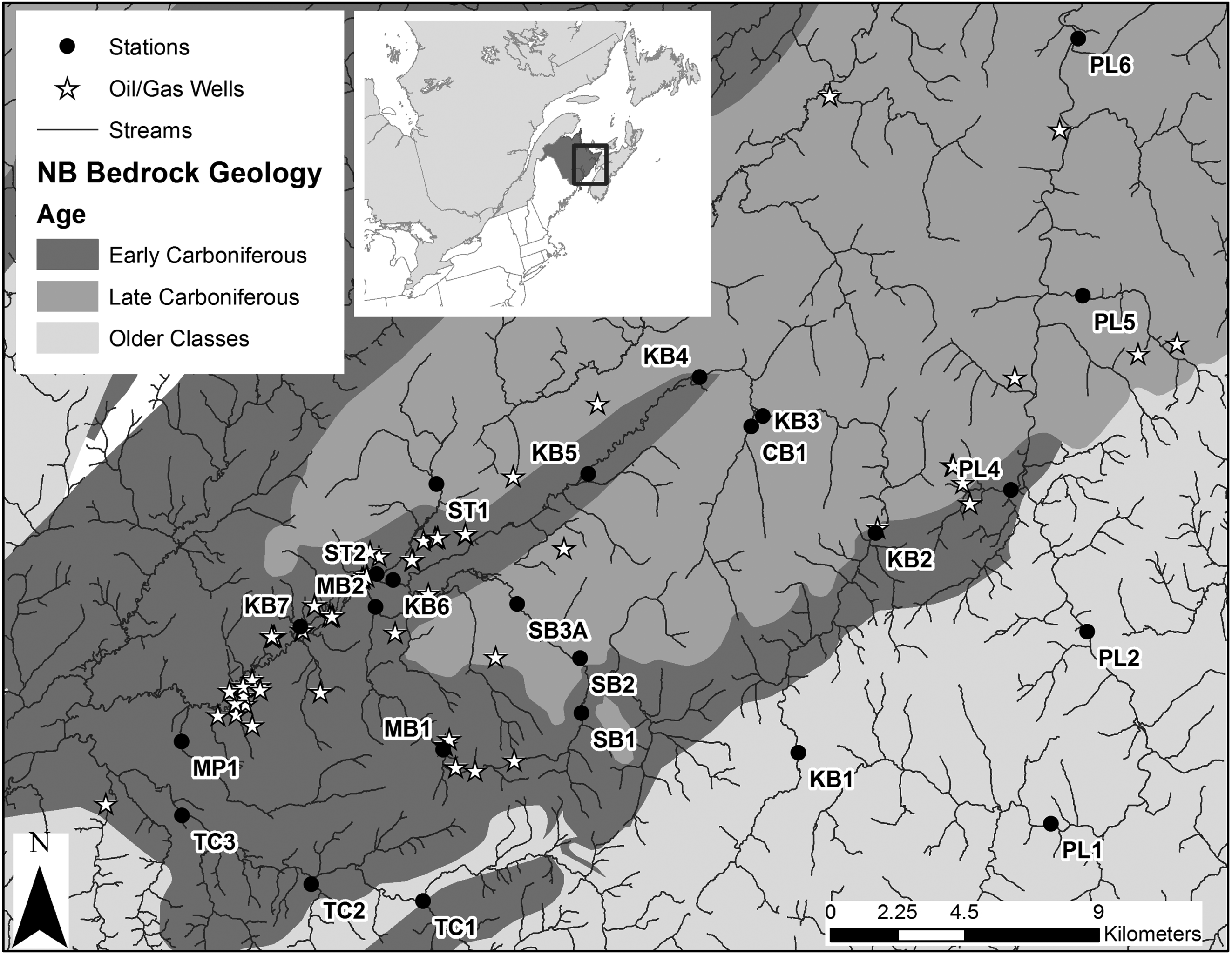
An extensive spatial survey was completed in late August and early September 2015 to characterize fish and BMI assemblage structure, water chemistry, and physical habitat in the Kennebecasis and Pollett watersheds (n = 18 and 6 stations, respectively; Fig. 1). Selection of sampling areas utilized existing geographic information system (GIS) data for topography, geology, and land use information, complemented by local knowledge. Site selection followed a stratified random sampling design to ensure coverage over a variety of catchment sizes across a natural habitat gradient. Mainstem and tributary stations were selected to cover a range of sub-catchment areas from 7.25 to 292.73 km2 (Table 1). Stations were classified by underlying geological age as Early Carboniferous, Late Carboniferous, or Older Classes (Devonian-Carboniferous and Neoproterozoic) based on the dominant age of geology in a 1-km upstream catchment buffer (see Lento et al. 2019). Several of the Early Carboniferous stations were located in the vicinity of oil and gas wells (Fig. 1), though active fracking activities were halted in the area in 2014 after the provincial government imposed a moratorium, and many wells were out of operation prior to the moratorium. Groundwater methane levels measured in private wells in the area were elevated compared to surrounding areas, but there was no correlation with proximity to oil and gas wells, which indicated that these were naturally high methane levels (Loomer et al. 2016). Furthermore, spills associated with unconventional shale-gas production have not been reported for the area, and chloride levels in surface waters were not correlated with proximity to oil and gas wells; thus, stations were considered to be least disturbed condition sites (sensu Stoddard et al. 2006).
Table 1.
| Station | Stream name | Latitude | Longitude | Catchment area (km2) | Geological age |
|---|---|---|---|---|---|
| CB1 | Calamingo Brook | 45.82396 | −65.22416 | 18.33 | Late Carboniferous |
| KB1 | Kennebecasis River | 45.72493 | −65.20672 | 16.08 | Older Classes |
| KB2 | Kennebecasis River | 45.79116 | −65.17107 | 52.47 | Early Carboniferous |
| KB3 | Kennebecasis River | 45.82706 | −65.21902 | 77.73 | Late Carboniferous |
| KB4 | Kennebecasis River | 45.83904 | −65.24611 | 108.39 | Late Carboniferous |
| KB5 | Kennebecasis River | 45.81035 | −65.29384 | 119.82 | Early Carboniferous |
| KB6 | Kennebecasis River | 45.77914 | −65.37976 | 220.07 | Early Carboniferous |
| KB7 | Kennebecasis River | 45.76548 | −65.42001 | 292.73 | Early Carboniferous |
| MB1 | McLeod Brook | 45.72736 | −65.36009 | 7.25 | Early Carboniferous |
| MB2 | McLeod Brook | 45.77112 | −65.38745 | 24.17 | Early Carboniferous |
| MP1 | Millpond Brook | 45.73120 | −65.47202 | 13.39 | Early Carboniferous |
| PL1 | Pollett River | 45.70245 | −65.09772 | 72.37 | Older Classes |
| PL2 | Pollett River | 45.75614 | −65.07883 | 122.99 | Older Classes |
| PL4 | Lee Brook | 45.80344 | −65.11241 | 22.36 | Early Carboniferous |
| PL5 | Colpitts Brook | 45.86169 | −65.07990 | 12.61 | Late Carboniferous |
| PL6 | Pollett River | 45.93900 | −65.07997 | 247.8 | Late Carboniferous |
| SB1 | Negro Brook | 45.73813 | −65.29926 | 8.14 | Early Carboniferous |
| SB2 | South Branch | 45.75476 | −65.29966 | 46.37 | Late Carboniferous |
| SB3A | South Branch | 45.77139 | −65.32639 | 55.61 | Late Carboniferous |
| ST1 | Stone Brook | 45.80803 | −65.36037 | 19.68 | Late Carboniferous |
| ST2 | Stone Brook | 45.78099 | −65.38686 | 27.84 | Early Carboniferous |
| TC1 | Cedar Camp | 45.68205 | −65.36880 | 36.43 | Older Classes |
| TC2 | Parlee Brook | 45.68751 | −65.41667 | 38.97 | Early Carboniferous |
| TC3 | Trout Creek | 45.70886 | −65.47225 | 150.16 | Early Carboniferous |
Note: Coordinates are presented in decimal degrees. Geological age is the dominant age class in a 1-km upstream catchment buffer (Early Carboniferous, Late Carboniferous, or Older Classes, including Neoproterozoic and Devonian-Carboniferous).
Sample collection and processing
Water grab samples were collected following provincial guidelines and were analyzed at the New Brunswick Department of Environment and Local Government’s analytical lab. Samples were analyzed for a standard suite of metals, nutrients, and ions following standardized analytical procedures (Table S1). A habitat survey was conducted at each station following protocols of the national Canadian Aquatic Biomonitoring Network (CABIN; Environment Canada 2012), including measurement of stream width, depth, velocity, and bed slope; description of in-stream and riparian vegetation and periphyton coverage; and a rock walk (Table S2). During the rock walk, 100 particles were chosen at random from within the sampled habitat, and the length of the intermediate axis length was recorded in mm (after Wolman 1954). Substrate measurements were grouped by grain size (using the Wentworth scale; see Environment Canada 2012) to quantify the percent composition of different size classes (e.g., sand, gravel, cobble) and median particle size (D50).
BMI samples were collected following standard CABIN protocols (Environment Canada 2012). The operator held a 400-μm mesh kick-net downstream while travelling through the stream channel in a zig-zag fashion and disturbing the substrate for a period of 3 min (Environment Canada 2012). BMI samples were randomly subsampled in the laboratory using the Marchant box method (Environment Canada 2014) until a minimum of 300 organisms was counted. Non-Chironomidae (midge) taxa were sent to an independent Society for Freshwater Science (SFS)-certified taxonomist for identification to genus level where possible, and Chironomidae taxa were sent to EcoAnalysts, Inc. to be identified to species by SFS-certified taxonomists (see Lento et al. 2019 for more details). Samples contained large numbers of taxa that were too small (early instars) to identify to the level of genus and to avoid mixed-level taxonomy within an order (which may lead to misrepresentation of trends), data were rolled up to the level of subfamily for Chironomidae and the level of family or higher for all other organisms. Bowman and Bailey (1997) demonstrated that analysis of BMI communities at the level of genus did not improve the ability to detect patterns in the data.
Fish community surveys were conducted by using a backpack electrofishing unit (Smith-Root LR-24, Vancouver, WA, USA) to fish an extent of the stream site containing at least one riffle and one pool or run in a single upstream pass (stream area ranged from 50 to 830 m2). The effort was standardized by maintaining power within a range of 65–75 W (voltage varied depending on conductivity of the water) and sampling time ranged from 419 to 3009 s. All fish were identified to species level.
Temperature loggers (Onset HOBO UA-001-08, UA-002-64, and U24-001, Bourne, MA, USA) were deployed in stream sites in May 2015 to capture longer-term temperature trends. Loggers were anchored by rebar driven into the substrate and were housed in light gray PVC pipe to avoid effects from solar radiation and shield them from damage caused by shifting substrate. The loggers recorded data every 30 min from May to November. Logger data were examined for records that indicated the logger was out of water (e.g., spikes in temperature or light levels, or decrease in conductivity to near 0 for the combination temperature/conductivity loggers). These records were removed, and remaining data were used to calculate summary temperature metrics for the summer period (June–August), including the number of degree days above 19 °C and the coefficient of variation (CV) of temperature. Catchment area upstream of each station was delineated by using the Hydrology tools in the Spatial Analyst toolbox to analyze a 30 m resolution Digital Elevation Model (DEM; Canada Digital Elevation Data; open.canada.ca/data) in ArcGIS (version 10.3, ESRI, St. Paul, Minnesota, USA). Additional geospatial variables were considered for analysis, including catchment vegetation and slope, but in-stream measures were retained to reduce the number of variables for the analysis. Surficial geology was also characterized from available geospatial layers but was correlated with the bedrock geology classes and therefore removed from the analysis to avoid masking differences in water chemistry and physical habitat variables among geologic age classes.
Data analysis
Characterization of stations
Multivariate data analysis was used to characterize the abiotic environment of the stream stations. Principal components analysis (PCA) was run with water quality and physical habitat data to assess similarities among stations. Data were pretreated by replacing water chemistry values that were below the limit of quantification (LOQ) with a value of half the LOQ. Prior to performing the PCAs, water quality parameters with extremely low detection frequency (defined as a water quality parameter that was only measured above the LOQ for fewer than two stations) were removed. The resulting subset of water quality and physical habitat variables was log10- or logit-transformed as appropriate to lessen the effect of extreme values and was analyzed in a PCA of the correlation matrix (centering and standardizing by variable scores) to control for the range of measurement scales in the abiotic variables. PCA biplots with station symbols coloured to reflect dominant underlying geological age were examined to evaluate associations of sample stations in multidimensional space, reflecting similarity in water quality or habitat conditions.
Stations were also characterized with respect to their biotic communities through multivariate analysis. Analysis was conducted separately on BMI data (at the level of subfamily for Chironomidae and family or higher for other taxa) and on fish data (at the species level; see Tables 2 and 3 for taxon names and abbreviations). Both sets of data were converted to relative abundances to focus on compositional differences, and data were transformed using log10 (x + 1) to dampen the effect of extreme values and reduce asymmetry (Legendre and Legendre 2012). Transformed BMI data were adjusted by adding 0.1 to further downweight the effect of rare taxa. PCA was run separately for BMI and fish data, in both cases post-transforming taxa scores to represent standardized scores on the resultant biplot. PCA biplots with station symbols coloured to reflect dominant underlying geological age were visually assessed to evaluate similarities and differences among stations with respect to assemblage composition.
Table 2.
| Class/order | Family/subfamily | Abbreviation |
|---|---|---|
| Coleoptera | Elmidae | C_Elm |
| Diptera | Athericidae | D_Ath |
| Ceratopogonidae | D_Cerat | |
| Chironomidae Chironominae | D_C_Chin | |
| Chironomidae Diamesinae | D_C_Dia | |
| Chironomidae Orthocladiinae | D_C_Orth | |
| Chironomidae Tanypodinae | D_C_Tany | |
| Ephydridae | D_Eph | |
| Muscidae | D_Musc | |
| Sciomyzidae | D_Scio | |
| Simuliidae | D_Simu | |
| Tabanidae | D_Tab | |
| Tipulidae | D_Tipu | |
| Ephemeroptera | Baetidae | E_Bae |
| Baetiscidae | E_Baesc | |
| Ephemerellidae | E_Ephe | |
| Heptageniidae | E_Hept | |
| Isonychiidae | E_Iso | |
| Leptohyphidae | E_Lepthy | |
| Leptophlebiidae | E_Lepto | |
| Megaloptera | Corydalidae | M_Cory |
| Odonata | Gomphidae | O_Gomp |
| Plecoptera | Capniidae | P_Cap |
| Chloroperlidae | P_Chl | |
| Leuctridae | P_Leu | |
| Nemouridae | P_Nem | |
| Perlidae | P_Perl | |
| Perlodidae | P_Perlo | |
| Pteronarcyidae | P_Ptero | |
| Taeniopterygidae | P_Taen | |
| Trichoptera | Apataniidae | T_Apa |
| Brachycentridae | T_Bra | |
| Goeridae | T_Goer | |
| Glossosomatidae | T_Glos | |
| Helicopsychidae | T_Hel | |
| Hydropsychidae | T_Hpsy | |
| Hydroptilidae | T_Hpti | |
| Lepidostomatidae | T_Lepi | |
| Leptoceridae | T_Lept | |
| Limnephilidae | T_Limn | |
| Odontoceridae | T_Odont | |
| Philopotamidae | T_Phil | |
| Polycentropodidae | T_Poly | |
| Psychomiidae | T_Psy | |
| Rhyacophilidae | T_Rhya | |
| Uenoidae | T_Ueno | |
| Acari | Trombidiformes (6 families) | Acari |
| Amphipoda | Gammaridae and unknown | Amph |
| Bivalvia | Pisidiidae | Bivalvia |
| Hirudinea | Hirudinea unknown | Hiru |
| Oligochaeta | Enchytraeidae | Oli_Ench |
| Lumbriculidae | Oli_Lumb | |
| Naididae | Oli_Naid |
Table 3.
| Species | Abbreviation |
|---|---|
| American Eel | EEL |
| Atlantic Salmon | ATS |
| Blacknose Dace | BND |
| Blacknose Shiner | BNS |
| Brook Trout | BKT |
| Burbot | BUR |
| Common Shiner | CSH |
| Golden Shiner | GSH |
| Lake Chub | LKC |
| Ninespine Stickleback | 9SB |
| Sea Lamprey | SLP |
| Slimy Sculpin | SLS |
| Threespine Stickleback | 3SB |
| White Sucker | WHS |
Analysis of community concordance
Procrustes analysis was used as a test of community concordance to determine whether similar gradients were evident when stations were assessed using different biotic assemblages. Procrustes analysis compares the spatial arrangement of stations in multivariate space between two ordinations (one target ordination, one rotational ordination) by translating and rotating the rotational ordination to match the target ordination as closely as possible. Residual vectors describe deviations of sample points from their location in the target ordination to their location in the rotational ordination, and the sum of squared residuals ( ) provides an estimate of the fit of the two ordinations, with a high statistic being indicative of strong differences between the two ordinations.
To test for community concordance, Procrustes analysis was used to compare the PCA ordinations of stations based on BMI relative abundance and fish relative abundance. For the analysis, the fish PCA was the target ordination and the benthic macroinvertebrate PCA was the rotational ordination. A randomization test was used as part of the analysis to test the significance of by comparing 9999 random configurations of the sample points with the target ordination; a significant p-value (at α = 0.05) was an indication that the target ordination and rotational ordination were more similar than could be obtained by chance (Jackson 1995).
Determination of baseline criteria
Water quality and biotic data were summarized as metrics and 95% confidence intervals were calculated to further characterize differences among geological age classes. The purpose of this analysis was to quantify the normal range of water quality and biotic metrics to establish baseline criteria for differentiating among geologic age classes, with a focus on metrics that differentiated Early Carboniferous stations. Metrics were chosen based on parameters that characterized Early Carboniferous stations in the abiotic and biotic PCAs and also included metrics that were used to differentiate among geologic age classes in Lento et al. (2019). For water quality, this included conductivity, nitrate, total phosphorus (TP), turbidity, and total organic carbon (TOC). For BMI, biotic metrics included: abundance; genus richness; % Chironomidae; % Ephemeroptera, Plecoptera, and Trichoptera (EPT); % noninsects; % Mollusca; and % Oligochaeta. For fish, biotic metrics included catch per unit effort; species richness; % Brook Trout; and % Slimy Sculpin. Confidence intervals that did not overlap between geologic age classes, and thus indicated a significant difference in the normal range, were used to determine baseline normal ranges for metrics.
Assessment of environmental drivers
Biotic–abiotic associations were explored through multivariate analysis for both BMI and fish. Redundancy analysis (RDA) was run separately for BMI and fish data, constraining assemblage data to a subset of water quality and habitat variables to identify the dominant drivers of assemblage composition in the stream systems. The RDA was run with forward selection, limiting the final set of environmental variables to a maximum of nine to avoid over-fitting (as there were only 14 fish species). However, the same initial set of environmental variables was used to create the model for BMI and fish to assess the relative importance of environmental variables to both BMI and fish composition. Prior to analysis, the full suite of environmental variables was reduced by testing Pearson correlations among drivers to remove highly redundant variables (those with |r| > 0.6). The final subset of environmental variables used to build the RDA models is indicated in Tables S1 and S2. Because environmental variables were measured at different scales, the RDAs were run on the correlation matrix by centering and standardizing by species. For each RDA, the variance explained by each axis was compared with the total variance in the biotic community (unconstrained variance) to assess the strength of the chosen variables to explain patterns in community similarities among stations. The significance of each environmental variable included in the RDA was assessed using a Monte Carlo permutation test with 999 permutations. Biplots were used to visually assess biotic–abiotic associations among stations, with station symbols coloured by underlying geological age.
The subset of abiotic variables used in the RDAs was further assessed by relating it to a concordance gradient in the stations (as in Paavola et al. 2006). For this analysis, the station residuals from the Procrustes analysis of biotic data were considered to represent a gradient in community concordance across stations. This concordance gradient was compared with each environmental variable used in the water chemistry and habitat PCA through correlation analysis (Pearson product-moment correlations) to determine which abiotic variables were associated with changes in the level of concordance between fish and BMI.
Multivariate analyses (PCAs, RDAs, and significance tests) were run in Canoco version 4.55 (ter Braak and Šmilauer 2002). Procrustes analysis was run in R version 3.2.3 (R Development Core Team 2015) using the vegan package (Oksanen et al. 2015). Correlation of environmental variables and residuals was run in Systat 12 (version 12.02).
Results
Abiotic characterization
The PCA of water chemistry and habitat variables identified clear gradients in the data that were driven by a contrast between stations with high levels of ions, nutrients, and suspended sediment particles and stations that were more strongly associated with habitat descriptors. The first axis of the PCA, which explained 31.9% of the variance among stations, separated most Early Carboniferous stations from those underlain by Late Carboniferous or older classes of bedrock, as Early Carboniferous stations were generally positively correlated with conductivity, alkalinity, hardness, and ions (including Cl, Na, K, Ca, and SO4) as well as turbidity and the habitat variable bankfull depth (Fig. 2). On the opposite end of the first axis gradient, stations underlain by Late Carboniferous or older classes of bedrock were associated with a number of habitat variables, including higher D50 (large median particle size), larger bankfull width, presence of coniferous trees, more variable temperature (higher CV), increased dominance of deciduous trees, and higher cover of periphyton and boulders (Fig. 2).
Fig. 2.
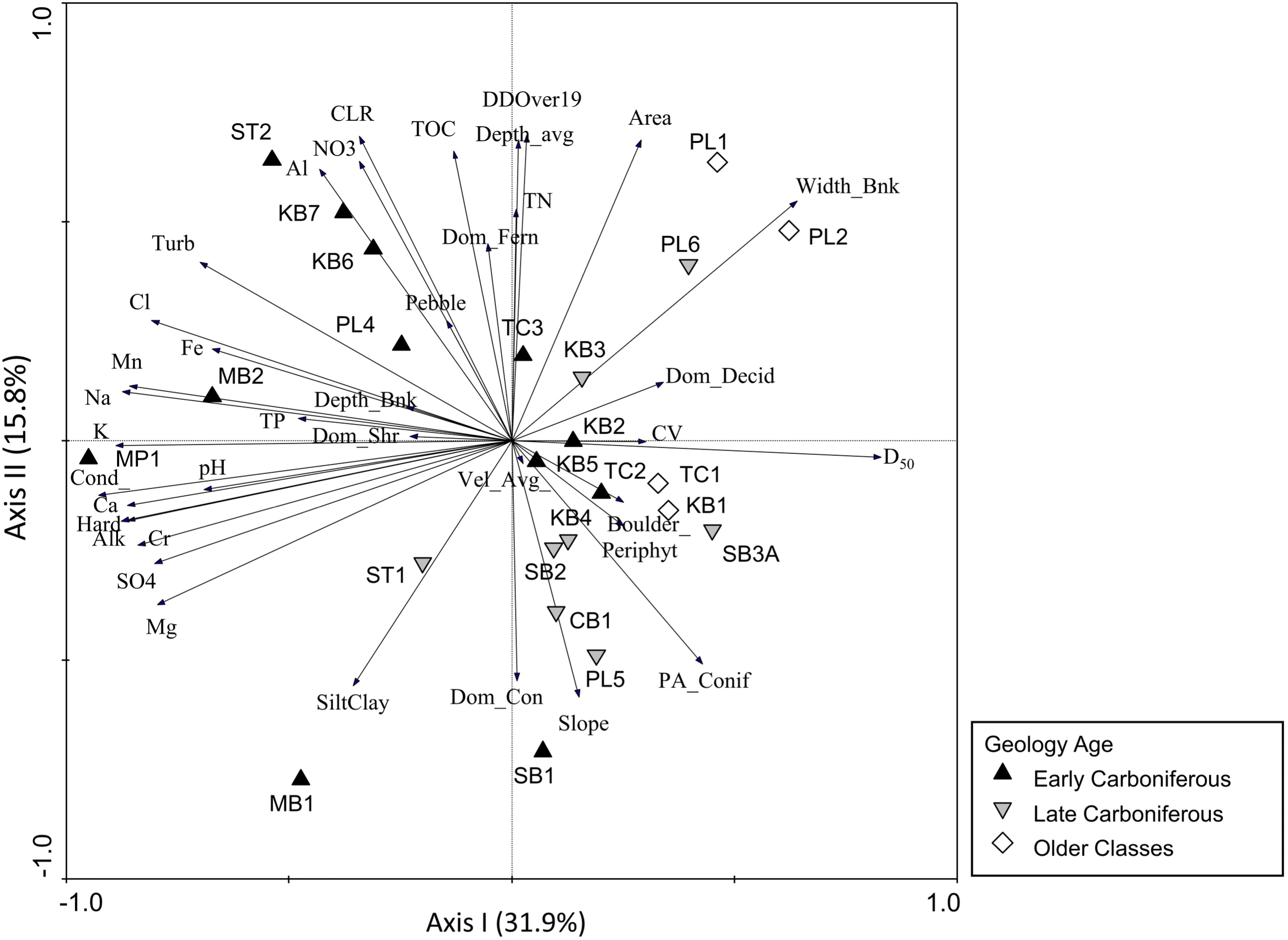
The second axis of the PCA explained 15.8% of the variance among stations and contributed to separation within each bedrock geology age class (Fig. 2). The positive end of the gradient was associated with degree days above 19 °C, average depth, catchment area, nutrients (TN, TOC, nitrate), colour, and aluminum (Fig. 2). Several Early Carboniferous stations (ST2, KB7, KB6, and PL4) followed a gradient in water chemistry along this axis. On the negative end of the gradient, stations were associated with high slope, dominance of coniferous vegetation, and % silt/clay (Fig. 2). Stations such as TC1, TC2, and KB4 (Older Class, Early Carboniferous, and Late Carboniferous, respectively) were negatively correlated with parameters such as TN, TOC, TP, colour, and turbidity and associated total metals such as Al and Fe (Fig. 2). In contrast, some stations on the Pollett River (PL1, PL2, and PL6) were positively associated with TN, TOC, and colour along the second axis while still reflecting a negative association with ions along the first axis. The third axis (not shown), which explained 11.2% of the variance among stations, was positively correlated with TP (associated with Early Carboniferous stations) and periphyton cover (associated with Late Carboniferous stations).
Biotic characterization
Multivariate assessment of BMI community structure indicated a strong separation of stations along the first and second axes that was similar to patterns in the water quality and habitat PCA. The first axis, which explained 31% of the variance in BMI samples, separated the Older Class stations and a small number of Early and Late Carboniferous stations with higher bankfull width and larger substrate size (stations PL1, PL2, PL6, TC1, and TC2) from the majority of other stations (Fig. 3A). Stations that were positively correlated with the first axis were associated with Odonata and nine families of Trichoptera (Apataniidae, Helicopsychidae, Hydropsychidae, Lepidostomatidae, Leptoceridae, Odontoceridae, Philopotamidae, Polycentropidae, and Psychodidae) whereas only four Trichoptera families were strongly associated with the negative end of the gradient (Brachycentridae, Glossosomatidae, Hydroptilidae, and Rhyacophilidae; Fig. 3A). Plecoptera families appeared evenly distributed along the length of the first axis (including Cloroperlidae, Perlidae, Perlodidae, and Pteronarcyidae on the positive end and Capniidae, Leuctridae, and Nemouridae on the negative end; Fig. 3A), suggesting a wide range of preferences to the underlying environmental gradient. The second PCA axis, which described 16.9% of community variance, was positively correlated with a group of predominantly Early Carboniferous stations that had high conductivity and high concentrations of ions, and was negatively correlated with most Late Carboniferous stations (Fig. 3A). Along the second axis, a large number of taxa were positively associated with the Early Carboniferous stations, including Coleoptera (Elmidae), several families of Ephemeroptera (including Ephemerellidae, Leptohyphidae, and Leptophlebiidae) and Trichoptera (Goeridae, Glossosomatidae, Hydropsychidae, Psychomiidae, and Uenoidae), and most noninsect groups, such as Oligochaeta, Bivalvia, Hirudinea, and Acari (Fig. 3A).
Fig. 3.
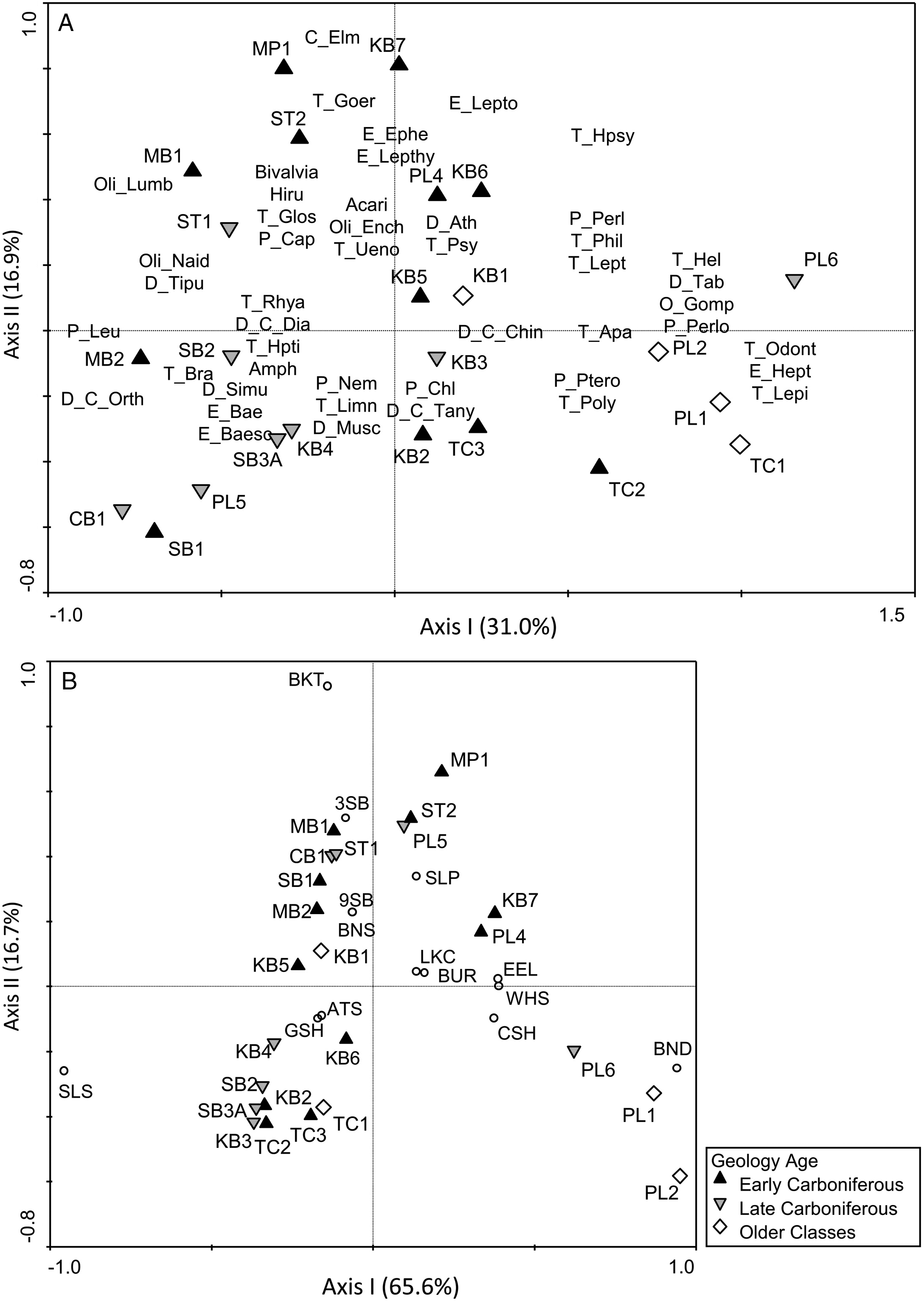
The PCA based on fish relative abundance explained a great deal of variation in the community data, but did not appear to distinguish strongly among bedrock geology age classes (Fig. 3B). The first axis, which explained 65.6% of the variance in the fish community, was positively associated with Pollett River stations PL1, PL2, and PL6, and more weakly correlated with the remaining stations (Fig. 3B). This axis was primarily driven by a negative association between Slimy Sculpin (Cottus cognatus; on the negative end of the gradient) and Blacknose Dace (Rhinichthys atratulus; on the positive end of the gradient), though other stations on the positive end of the gradient were also positively correlated with taxa such as American Eel (Anguilla rostrata), White Sucker (Catostomus commersonii), and Common Shiner (Luxilus cornutus; Fig. 3B). The second axis explained much less community variance (16.7%) but represented a gradient in Brook Trout (Salvelinus fontinalis) abundance along which most stations differed. Brook Trout were positively correlated with Threespine Stickleback (Gasterosteus aculeatus) but were weakly or uncorrelated with other fish species (Fig. 3B).
Community concordance
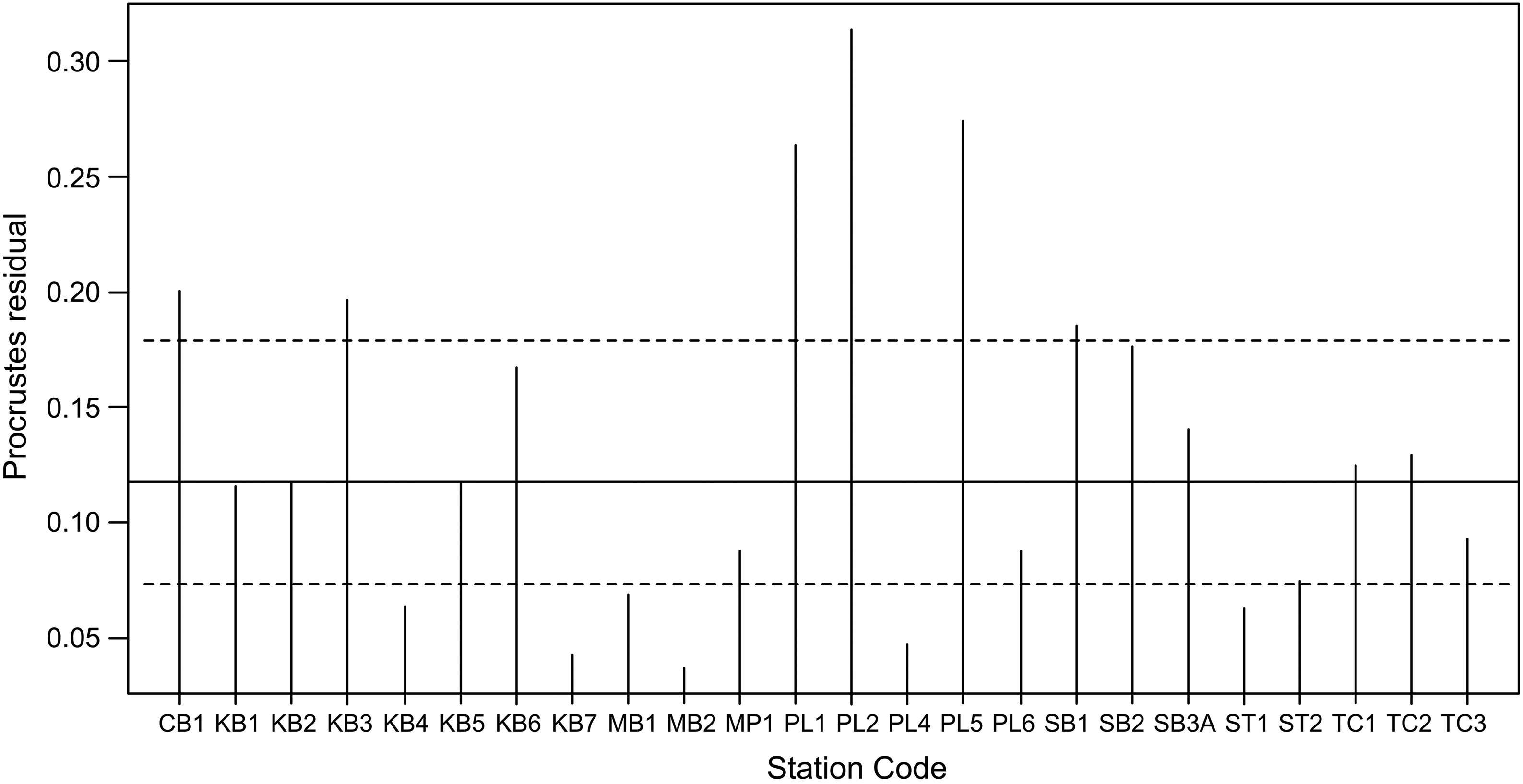
Procrustes analysis indicated that the fit of the BMI PCA (rotational ordination) to the fish PCA (target ordination) was more similar than could be obtained by chance ( = 0.56; p = 0.001 after 999 permutations). The largest residual difference was found for station PL2 (residual vector length = 0.313), and two other stations had moderately long residual vectors (e.g., PL1 and PL5; Fig. 4), suggesting that the similarity of these stations to other stations differed depending on whether fish or BMI data were considered. However, residual vectors were short for most stations, indicating significant community concordance that was evident as a strong overall similarity between the fish ordination and the BMI ordination.
Fig. 4.
Baseline criteria
Baseline criteria were established through analysis of confidence intervals in water quality and biotic metrics, with the differences predominantly found between Early Carboniferous and Older Class stations. Conductivity, which was strongly associated with Early Carboniferous stations in the abiotic PCA, was higher on average in Early Carboniferous stations (mean = 167.9 μS/cm) than in Older Class stations (mean = 41.62 μS/cm), and 95% confidence intervals for these geologic age classes did not overlap (Table 4). Similarly, TP was higher on average in Early Carboniferous stations (mean = 0.013 mg/L) than in Older Class stations (mean = 0.003 mg/L) and confidence intervals did not overlap (Table 4). Nitrate differed significantly between Early and Late Carboniferous stations (results not shown), but the 95% confidence intervals of Older Class stations overlapped with both other classes. Estimates of the normal range for other water quality parameters overlapped between Early Carboniferous, Late Carboniferous, and Older Class stations, which indicated that there was insufficient distinction among geologic classes to allow their use for establishing baseline criteria from the normal range.
Table 4.
| Metric type | Metric | Geologic class | Mean | Lower CI | Upper CI |
|---|---|---|---|---|---|
| Water quality | Conductivity | Early Carboniferous | 167.9 | 77.1 | 258.7 |
| Older Classes | 41.6 | 21.2 | 62.0 | ||
| Total phosphorus (TP) | Early Carboniferous | 0.013 | 0.007 | 0.020 | |
| Older Classes | 0.003 | 0.001 | 0.005 | ||
| Benthic macroinvertebrate | Abundance | Early Carboniferous | 25 046.2 | 16 472.5 | 33 619.8 |
| Older Classes | 8534 | 2996.3 | 14 071.7 | ||
| Genus richness | Early Carboniferous | 37.9 | 34.9 | 40.9 | |
| Older Classes | 30.2 | 26.5 | 33.9 | ||
| % Chironomidae | Early Carboniferous | 34.5 | 27.6 | 41.4 | |
| Older Classes | 18.6 | 10.0 | 27.2 | ||
| % Ephemeroptera, Plecoptera, Trichoptera (EPT) | Early Carboniferous | 47.4 | 40.8 | 54.0 | |
| Older Classes | 73.5 | 66.3 | 80.8 | ||
| % Oligochaeta | Early Carboniferous | 1.25 | 0.48 | 2.03 | |
| Older Classes | 0.19 | −0.05 | 0.44 |
Note: Only metrics that differentiate between these geological age classes (i.e., confidence intervals don’t overlap) are presented.
There were a number of BMI metrics for which it was possible to develop baseline criteria from the normal range, with all differences found between Early Carboniferous and Older Class stations. Total abundance of BMI was highest on average in Early Carboniferous stations (mean = 25 046.2) and the 95% confidence interval for this geologic class did not overlap with Older Class stations (mean = 8534; Table 4). Taxonomic richness was also higher on average in Early Carboniferous stations (mean = 37.9) than in other geologic classes, and the 95% confidence interval did not overlap with that for Older Class stations (mean = 30.2; Table 4). The remaining metrics that were used to establish baseline criteria reflected the stronger association of Early Carboniferous stations with noninsect taxa and weaker association with EPT taxa in the BMI PCA. The % EPT was higher on average in Older Class stations (mean = 73.5%) than other geologic age classes, particularly Early Carboniferous (mean = 47.4%), and confidence intervals for Early Carboniferous and Older Class stations did not overlap (Table 4). In contrast, the % Chironomidae (the other dominant taxonomic group in these systems) was significantly higher on average in Early Carboniferous stations (mean = 34.5%) than Older Class stations (mean = 18.6%), as was the % Oligochaeta (Early Carboniferous mean = 1.25% and Older Class mean = 0.19%; Table 4).
In contrast to the BMI, there were no fish metrics that differed significantly among geologic age classes, which supported the generally weaker differentiation of Early Carboniferous stations that was evident in the fish PCA. Although species richness was higher in Early Carboniferous stations than Older Class stations, the 95% confidence intervals for these two geologic age classes indicated no significant differences (Early Carboniferous confidence interval range: 4.1–6.8; Older Class confidence interval range: 0.7–5.3). It was therefore not possible to establish baseline criteria for fish metrics to distinguish among geologic age classes and characterize a distinct normal range for Early Carboniferous stations.
Biotic–abiotic associations
Forward selection of variables for Redundancy Analysis resulted in similar sets of environmental variables for analysis of BMI and fish (8 of the 9 final variables were the same in both RDAs), though the relative importance of those variables differed. Notably, the set of variables that was significant in the RDA model differed, as BMI were significantly (p < 0.05) associated with (in order of importance) temperature (degree days over 19 °C), conductivity, and catchment area, whereas fish were significantly associated with catchment area, turbidity, and TN (Table 5). Conductivity, which was strongly associated with Early Carboniferous stations and significant in the BMI RDA, was included in the final fish model, but was one of the weakest variables in the model (Table 5). Average velocity and TP were not included in the final model for either BMI or fish, and only the fish RDA included a substrate size variable (% pebble), whereas slope was only selected in the BMI RDA (Table 5).
Table 5.
| BMI | Fish | ||||||
|---|---|---|---|---|---|---|---|
| Variable | Lambda-A | F | p | Variable | Lambda-A | F | p |
| DDOver19 | 0.12 | 2.92 | 0.002 | Area | 0.13 | 3.39 | 0.001 |
| Cond | 0.08 | 2.27 | 0.006 | Turb | 0.11 | 3.00 | 0.008 |
| Area | 0.06 | 1.50 | 0.032 | TN | 0.09 | 2.73 | 0.014 |
| Turb | 0.05 | 1.40 | 0.092 | Depth_avg | 0.04 | 1.36 | 0.240 |
| TN | 0.05 | 1.33 | 0.106 | PA_Conif | 0.05 | 1.34 | 0.228 |
| PA_Conif | 0.04 | 1.33 | 0.130 | DDOver19 | 0.04 | 1.23 | 0.263 |
| Depth_avg | 0.05 | 1.25 | 0.120 | Periphyt | 0.04 | 1.22 | 0.282 |
| Slope | 0.04 | 1.17 | 0.258 | Cond | 0.03 | 1.05 | 0.406 |
| Periphyt | 0.04 | 1.09 | 0.294 | Pebble | 0.03 | 0.98 | 0.447 |
The spatial arrangement of stations and BMI taxa in constrained ordination space was similar between the RDA biplot and the BMI PCA, which was indicative of the strong contribution of the selected water chemistry and habitat variables to the environmental gradient underlying patterns in BMI community composition. The first axis of the RDA explained 14.6% of the unconstrained variance in BMI assemblage composition, and the second axis explained an additional 8.6% of the unconstrained assemblage variance (Fig. 5A). Several stations in the Pollett River catchment (PL1, PL2, PL4, and PL6) were positively associated with higher temperatures, larger catchment area, higher average depth, and higher TN along the first axis of the RDA (Fig. 5A). A large number of Late Carboniferous stations were negatively correlated with this gradient and with the second axis, and these stations were associated with lower temperatures, smaller catchment area and depth, lower TN, high periphyton coverage and high slope (stations CB1, PL5, ST1, KB4, and SB3A; Fig. 5A). In contrast, six of the Early Carboniferous stations were associated with high conductivity and turbidity along the second axis gradient. Plecoptera and Trichoptera families were distributed along the first axis, as in the BMI PCA, whereas the Early Carboniferous stations on the positive end of the second axis gradient (associated with high conductivity and turbidity) were still positively associated with noninsect groups and a small number of insect families (Fig. 5A).
Fig. 5.
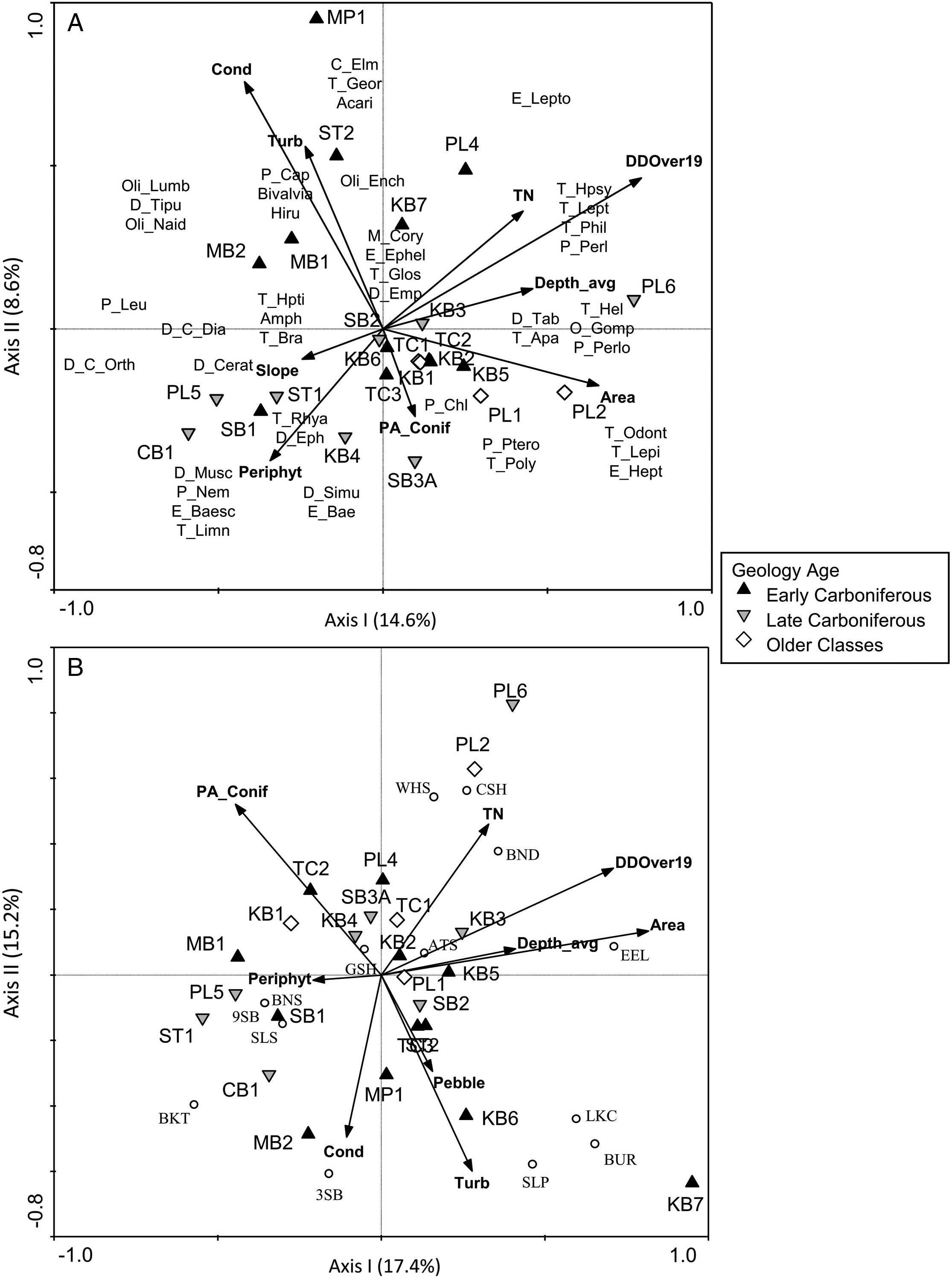
Separation of stations in the fish RDA showed a weaker grouping of geological age classes, with most classes distributed across the ordination (Fig. 5B). The first axis, which explained 17.4% of the constrained variance, was primarily driven by a gradient in temperature, catchment area, depth, and TN, as in the BMI RDA. However, Pollett River stations were largely uncorrelated with this axis, and the gradient was driven by a negative association of these variables with stations such as ST1, PL5, SB1, MB1, and CB1 (Fig. 5B). Brook Trout, and to a lesser extent Slimy Sculpin, Ninespine Stickleback (Pungitius pungitius), and Blacknose Shiner (Notropis heterolepis) were negatively associated with system size and temperature along the first axis gradient. The second axis indicated a gradient in conductivity and turbidity, both of which were positively associated with a number of Early Carboniferous stations (Fig. 5B). On the other end of that axis, stations in all geological age classes were positively associated with the presence of coniferous vegetation or TN. Brook Trout and Threespine Stickleback were positively correlated with conductivity along the second axis, whereas Burbot (Lota lota), Lake Chub (Couesius plumbeus), and Sea Lamprey (Petromyzon marinus) were positively associated with turbidity (Fig. 5B).
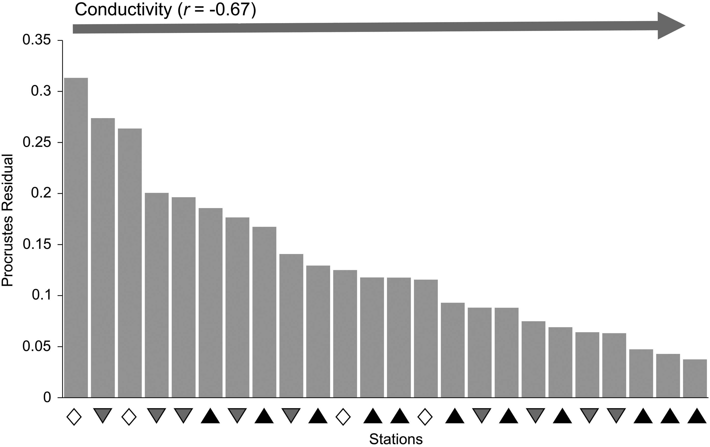
Concordance gradient
A concordance gradient was created by aligning stations in order of decreasing Procrustes residuals, using the results of the analysis of fish and BMI concordance (i.e., as plotted in Fig. 4). Geology age classes were generally spread across the gradient, although the highest residuals were found in Older Class and Late Carboniferous stations, whereas the lowest residuals were found in Early Carboniferous stations (Fig. 6), indicating stronger similarity in station characterization based on fish and BMI for Early Carboniferous stations. The strongest correlation of environmental variables with the concordance gradient was a negative correlation of residual values with conductivity (r = −0.67) that indicated that concordance between fish and BMI increased as conductivity increased (Fig. 6). Other environmental variables were generally weakly correlated with the concordance gradient (|r| < 0.30; results not shown), but there was evidence of a positive correlation with D50 (r = 0.43) and bankfull width (r = 0.38) that indicated a decline in concordance (increasing Procrustes residuals) with an increase in substrate size and system size.
Fig. 6.
Discussion
Monitoring and assessment to detect the potential impacts of shale-gas activities relies on the identification of appropriate response variables, including the selection of monitoring endpoints that will respond to relevant anthropogenic stressors. In our study, BMI assemblage structure was strongly related to water chemistry variables such as conductivity, which characterized areas with shale-gas potential, and the normal range of conductivity as well as several BMI metrics in Early Carboniferous stations were distinct from stations without shale-gas potential. Conductivity, in particular, would be expected to change in response to spills or other potential impacts of unconventional gas production, such as groundwater contamination, overland runoff, or release of treated effluents, which implies a strong potential for BMI abundance and composition to be used as a diagnostic tool to detect shale-gas impacts. In contrast, fish assemblage composition had a stronger association with a gradient in nutrients that was independent of geologic age, and with turbidity, which was highest in stations with high shale-gas potential. Despite the difference in driving variables, BMI and fish provided similar characterization of study sites, as evidenced by significant concordance. The response of BMI and fish taxa to differing environmental drivers suggests that these two taxonomic groups could be utilized in concert to detect and identify community shifts in response to a number of different environmental and anthropogenic pressures.
Biotic associations across environmental gradients
Stations underlain by different geological age classes were characterized by environmental variables that have the potential to drive gradients in biotic assemblages (e.g., Snelder et al. 2004). Early Carboniferous stations, which have high shale-gas potential, were strongly characterized by high levels of several water chemistry variables (e.g., ions, conductivity, turbidity, and metals), which may be driven by underlying geologic composition (Johnson et al. 1997; Reimann et al. 2009). In contrast, stations underlain by Late Carboniferous or older classes of bedrock were more strongly associated with a range of habitat variables that were indicative of gradients in stream width, periphyton cover, and riparian vegetation. These results supported the idea that surface and groundwaters in distinctive geological regions might display characteristic abiotic conditions with unique chemical habitats (Stapinsky et al. 2002; Reimann et al. 2009; Neff and Jackson 2011, 2012). Furthermore, differences in conductivity and TP among geologic age classes in our study allowed the development of baseline criteria for monitoring based on the normal range for stations underlain by Early Carboniferous bedrock.
There was clearly a stronger association of BMI with conductivity, which was a defining feature of stations underlain by Early Carboniferous bedrock geology, whereas fish were more strongly associated with system size (catchment area and depth) and a gradient in nutrients that was not specific to a particular geologic age class. Neff and Jackson (2013) noted similar patterns when comparing stream systems on the Precambrian Shield and off-Shield, with BMI responding more strongly to water chemistry differences across geology types and fish predominantly responding to physical habitat variables. Conductivity and alkalinity played a dominant role in distinguishing between Shield and off-Shield stations in their study, and Neff and Jackson (2011) found an association of several noninsect groups (e.g., Gastropoda, Amphipoda, mites, Hirudinea, and Isopoda) with the higher ion levels in off-Shield stations, similar to our results. Furthermore, Johnson et al. (2015) sampled streams in active shale-gas development areas in the southern United States and found their BMI assemblages to be dominated by Oligochaeta, Chironomidae, and tolerant genera of Ephemeroptera, which corresponds to the BMI patterns seen in our study for Early Carboniferous stations. The predominance of noninsect groups in high conductivity waters underlain by Early Carboniferous bedrock may relate to the dependence of taxa such as gastropods and bivalves on uptake of calcium from the water to maintain shell growth (Havas and Rosseland 1995; Neff and Jackson 2013). Though conductivity appeared to be a less dominant driver for fish, it was positively correlated with both Brook Trout and Threespine Stickleback. Conductivity has been found to correlate with abundance (Scarnecchia and Bergersen 1987) and size (as outlined in Copp 2003) of some fish species including trout, with high conductivity stations equated to more productive systems. The positive association of Brook Trout relative abundance with both conductivity and periphyton in these streams appears to support this idea.
Physical habitat differences among stations were reflected by taxonomic associations of both BMI and fish with gradients in temperature and system size. For example, stations that were cooler were associated with Plecoptera taxa such as Leuctridae, Nemouridae, and Chloroperlidae, which prefer small cool-water streams (McCafferty 1998). Brook Trout were similarly associated with small cool-water streams, consistent with their preferred temperature of 16 °C (Coker et al. 2001). The strongest gradient in the fish PCA was a negative relationship along the first axis between Slimy Sculpin, which have a cool-water preference (11–16 °C; Lyons 1990), and stations PL1, PL2, and PL6, which were large, warm systems, with higher maximum summer temperatures than other systems (ranging from 26 to 27.5 °C). These stations had more degree days above 19 °C, and they were positively correlated with Pteronarcyidae, Perlidae, and Perlodidae, which inhabit larger systems and are more tolerant of warm temperatures (McCafferty 1998). Blacknose Dace and American Eel were the fish species that were most strongly associated with these warm-water stations, and these species have preferred temperatures of 24.6 °C and 19 °C, respectively (Coker et al. 2001). Temperature in our study was not specifically related to particular geological age classes, though O’Sullivan et al. (2019) found that surficial geology, slope, and areas of geologic contact could be used to predict stream temperatures. The Pollett River stations, which had the highest degree days above 19 °C and the most variable temperatures in our study, were large stations that also had low percent cover of riparian vegetation and low percent forest in the upstream catchment. Johnson (2004) found evidence that shading affected maximum temperatures in small stream systems, and the lack of riparian vegetation at the Pollett River stations may have contributed to increased temperatures, driving differences in BMI and fish assemblages.
Community concordance in relation to environmental drivers
The detection of significant community concordance among BMI and fish has two potential implications: (i) that the current range of environmental drivers in the study systems acts on BMI and fish in a similar manner, resulting in similar groupings of stations regardless of the organism examined and (ii) that there is redundancy in the evaluation of both BMI and fish assemblage structures within the same system, as they both lead to the same conclusion (Jackson and Harvey 1993). In the case of the Kennebecasis and Pollett River watersheds, the evaluation of both BMI and fish assemblages cannot be considered fully redundant as these groups of organisms appeared to respond most strongly to different environmental drivers. Other studies have noted significant concordance among organism groups despite evidence of differing responses to localized drivers (e.g., Jackson and Harvey 1993; Dolph et al. 2011; Bae et al. 2014). In particular, Neff and Jackson (2013) found significant community concordance between fish and BMI assemblages in Shield and off-Shield stream systems despite a stronger association of BMI with water chemistry variables and fish with physical habitat variables. Similar to our study, Neff and Jackson (2013) assessed streams within a localized region where there were distinct geological differences that had a significant effect on the physical and chemical habitat of the stream systems. Where the importance of drivers differs among groups that are concordant (e.g., fish and BMI), each assemblage could be expected to respond differently to future perturbation, which indicates that they provide complementary information about ecosystem condition.
Previous studies that have noted weaker concordance at smaller spatial scales (e.g., within drainage basins or within ecoregions) have attributed the difference in response of organism groups to strong localized differences in small-scale environmental drivers such as water chemistry and physical habitat (Paavola et al. 2003, 2006; Larsen et al. 2012). However, Paavola et al. (2006) suggested that concordance might be evident in small-scale assessments if there is a single, strong environmental gradient driving assemblages in a similar way. In our study, the geological topologies characterized by Early Carboniferous, Late Carboniferous, and older classes of bedrock may have acted in such a manner. The concordance gradient that we identified across stations indicated that the strongest concordance or consistency among fish and BMI was evident in small systems with small substrate size and high conductivity. This association with system size is contrary to the findings of Paavola et al. (2006), who found increased concordance in larger systems in their broadscale regional assessment of streams. However, this may speak to the strength of the geological gradient in the current study and the important distinction of Early Carboniferous (shale-gas producing) areas from those underlain by other geological formations, providing further evidence of the dominant role geology can play in characterizing freshwater habitats (e.g., Neff and Jackson 2011, 2012, 2013).
Monitoring surface waters in shale-gas formations
Though differences in system size, substrate size, and temperature were evident within and among geology age classes, water chemistry was the most important set of variables for characterizing Early Carboniferous stations. In a PCA including only water chemistry data (excluding physical habitat data), the first two axes explained 71.8% of the variance among sites (results not shown) further indicating the importance of water chemistry to distinguish among geology classes. Water chemistry also represents one of the characteristics of surface waters that is most likely to be impacted by potential spills, contamination by untreated flowback fluids (hydraulic fracturing fluids that return to the surface), or the release of treated effluent from shale -gas production (Entrekin et al. 2011; Vengosh et al. 2014). In their review of the potential impacts of hydraulic fracturing activities, Vengosh et al. (2014) noted that surface spills in the United States have caused high levels of organics, metalloids (Se, As), radionuclides (Ra), methane, pH, salts (total dissolved salts, and Cl and Br in particular), and specific conductivity. Wilson et al. (2014) found Cl levels in produced water from shale gas activities to be on average 133 733 mg/L, several orders of magnitude higher than the average Cl levels in the Early Carboniferous stations in the current study (8.38 mg/L), which were elevated compared to Cl levels in Late Carboniferous and Older Class stations (2.34 and 1.63 mg/L, respectively). Lento et al. (2019) found a number of ions had elevated levels in Early Carboniferous stations, consistent with the strong positive association of these stations with conductivity and ions in the present study. Given the already elevated levels of Cl and conductivity in the Early Carboniferous (high shale-gas potential) stations relative to other geological formations in the current study, this suggests the potential for even stronger geological distinction of stations if shale-gas production were to cause impacts to surface waters through wastewater spills. To support monitoring and detection of such impacts, baseline criteria can be developed by identifying the range of values outside which there may be evidence of impairment (normal range; Munkittrick et al. 2009). In our study, confidence intervals for conductivity provided evidence of the distinction among geologic age classes with respect to this chemical parameter, but also indicated the normal range for Early Carboniferous stations within which 95% of the conductivity values fell. With additional monitoring of streams in areas of potential shale gas development, these baseline criteria could be further refined to allow greater accuracy in the detection of impacts.
The stronger association of BMI with conductivity has important implications for biomonitoring in areas with high shale-gas potential, as it suggests that any changes to ion levels that might result from shale-gas production through spills or overland runoff may be most evident as impacts on BMI assemblages. Noninsect taxa and some families of Ephemeroptera and Trichoptera were highly associated with ion levels and could act as indicators of shifts in conductivity, whereas many Plecoptera in particular were more related to temperature gradients. BMI abundance, taxonomic richness, and the percent composition of Chironomidae, EPT, and Oligochaeta were all significantly different in stations underlain by Early Carboniferous bedrock relative to older classes of bedrock geology, similar to the patterns noted by Lento et al. (2019), and the baseline criteria developed for these metrics can be used to monitor how test stations compare with the expected normal range in the absence of impacts from shale-gas development. Fish assemblages provided complementary information by strongly reflecting other physical and chemical habitat characteristics that might be altered with shale-gas development (e.g., increased turbidity from development activities; Entrekin et al. 2011) and natural gradients (e.g., nutrients) that did not relate as strongly to geologic age. Shifts in fish assemblages may be expected to reflect impacts to the system that are related to more general land use and development changes, such as changes to nutrient and sediment regimes or habitat fragmentation caused by clearing the land for construction of wells and development of supporting infrastructure (Entrekin et al. 2011; Brittingham et al. 2014). Thus, monitoring of both BMI and fish may provide a measure of the relative strength of different anthropogenic impacts, including multiple aspects of shale-gas development, as taxonomic preferences and tolerance levels inform assessment of community shifts.
This study characterized the abiotic habitat and biotic communities of streams in geologic areas with high shale-gas potential, contrasting with streams on neighbouring geologic formations. There was clear evidence of differences in the abiotic habitat across geological age classes, and these differences were associated with variability in BMI and fish assemblage structure, with BMI more strongly reflecting temperature and conductivity and fish relating more to system size and gradients in nutrients and turbidity. Despite the differences in dominant drivers across organism groups, there was evidence of significant community concordance among BMI and fish assemblages, and this concordance increased with increasing conductivity and decreasing system size and substrate size. Geological age, differentiating Early Carboniferous, Late Carboniferous, and older classes of bedrock, appeared to act as a large-scale driver in these systems, contributing to concordance within the biotic community despite differences in localized environmental drivers (i.e., physical and chemical habitat variables), and the results of this study suggest that BMI and fish provide complementary information about ecosystem condition across the range of geology types examined. Effective environmental monitoring in areas of shale-gas development should therefore include assessment of both BMI and fish assemblages to allow for the detection of impacts related to shale-gas extraction as well as general perturbation related to development, with deviations from concordance used to detect assemblage-specific driver–response relationships. Importantly, baseline criteria developed in this paper provide estimates of the normal range for chemical and biotic metrics that might be affected by shale-gas development, thereby supporting the development of diagnostic tools for monitoring. This study highlights the importance of examining biotic response to environmental drivers in multiple assemblages to understand and interpret baseline conditions and ultimately measure meaningful change to adequately, and appropriately, inform management and biomonitoring of freshwater systems.
Acknowledgements
The authors would like to thank the field technicians that helped to collect the data for this project: Maggie Folkins, William Gushue, Hunter Francis, Adam Chateauvert, and Kirk Roach among others. This study was funded by the New Brunswick Energy Institute (NBEI), with additional support to AF from the Natural Sciences and Engineering Research Council (NSERC). The fish samples were collected under the UNB Animal Care permit AUP-15026. Comments from an anonymous reviewer greatly improved the manuscript.
References
Allen AP, Whittier TR, Larsen DP, Kaufmann PR, O’Connor RJ, Hughes RM, et al. 1999. Concordance of taxonomic composition patterns across multiple lake assemblages: effects of scale, body size, and land use. Canadian Journal of Fisheries and Aquatic Sciences, 56(11): 2029–2040.
Bae M-J, Li F, Kwon Y-S, Chung N, Choi H, Hwang S-J, et al. 2014. Concordance of diatom, macroinvertebrate and fish assemblages in streams at nested spatial scales: implications for ecological integrity. Ecological Indicators, 47: 89–101.
Bonada N, Prat N, Resh VH, and Statzner B. 2006. Developments in aquatic insect biomonitoring: a comparative analysis of recent approaches. Annual Review of Entomology, 51: 495–523.
Bowman MF, and Bailey RC. 1997. Does taxonomic resolution affect the multivariate description of the structure of freshwater benthic macroinvertebrate communities? Canadian Journal of Fisheries and Aquatic Sciences, 54: 1802–1807.
Bowman MF, Ingram R, Reid RA, Somers KM, Yan ND, Paterson AM, et al. 2008. Temporal and spatial concordance in community composition of phytoplankton, zooplankton, macroinvertebrate, crayfish, and fish on the Precambrian Shield. Canadian Journal of Fisheries and Aquatic Sciences, 65(5): 919–932.
Brittingham MC, Maloney KO, Farag AM, Harper DD, and Bowen ZH. 2014. Ecological risks of shale oil and gas development to wildlife, aquatic resources and their habitats. Environmental Science & Technology, 48(19): 11034–11047.
Coker G, Portt CB, and Minns CK. 2001. Morphological and ecological characteristics of Canadian freshwater fishes. Fisheries and Oceans Canada, Burlington, Vermont.
Copp G. 2003. Is fish condition correlated with water conductivity? Journal of Fish Biology, 63(1): 263–266.
Dolph CL, Huff DD, Chizinski CJ, and Vondracek B. 2011. Implications of community concordance for assessing stream integrity at three nested spatial scales in Minnesota, USA. Freshwater Biology, 56(8): 1652–1669.
Dow CL, Arscott DB, and Newbold JD. 2006. Relating major ions and nutrients to watershed conditions across a mixed-use, water-supply watershed. Journal of the North American Benthological Society, 25(4): 887–911.
Dyni JR. 2003. Geology and resources of some world oil-shale deposits. Oil Shale, 20(3): 193–253.
Entrekin S, Evans-White M, Johnson B, and Hagenbuch E. 2011. Rapid expansion of natural gas development poses a threat to surface waters. Frontiers in Ecology and the Environment, 9(9): 503–511.
Environment Canada. 2012. Canadian Aquatic Biomonitoring Network field manual—wadeable streams. Government of Canada Publications, Dartmouth, Nova Scotia. 57 p.
Environment Canada. 2014. Canadian Aquatic Biomonitoring Network laboratory methods: processing, taxonomy, and quality control of benthic macroinvertebrate samples. Government of Canada Publications, Dartmouth, Nova Scotia. 36 p.
Esselman PC, Freeman MC, and Pringle CM. 2006. Fish-assemblage variation between geologically defined regions and across a longitudinal gradient in the Monkey River Basin, Belize. Journal of the North American Benthological Society, 25(1): 142–156.
Goodsell P, Underwood A, and Chapman M. 2009. Evidence necessary for taxa to be reliable indicators of environmental conditions or impacts. Marine Pollution Bulletin, 58(3): 323–331.
Gregory KB, Vidic RD, and Dzombak DA. 2011. Water management challenges associated with the production of shale gas by hydraulic fracturing. Elements, 7(3): 181–186.
Havas M, and Rosseland BO. 1995. Response of zooplankton, benthos, and fish to acidification: an overview. Water, Air, & Soil Pollution, 85: 51–62.
Heino J. 2002. Concordance of species richness patterns among multiple freshwater taxa: a regional perspective. Biodiversity & Conservation, 11(1): 137–147.
Heino J, Paavola R, Virtanen R, and Muotka T. 2005. Searching for biodiversity indicators in running waters: do bryophytes, macroinvertebrates, and fish show congruent diversity patterns? Biodiversity & Conservation, 14(2): 415–428.
Hering D, Johnson RK, and Buffagni A. 2006. Linking organism groups—major results and conclusions from the STAR project. Hydrobiologia, 566: 109–113.
Infante DM, Allan JD, Linke S, and Norris RH. 2009. Relationship of fish and macroinvertebrate assemblages to environmental factors: implications for community concordance. Hydrobiologia, 623(1): 87–103.
Jackson DA. 1995. PROTEST: a PROcrustean Randomization TEST of community environment concordance. Écoscience, 2(3): 297–303.
Jackson DA, and Harvey HH. 1993. Fish and benthic invertebrates: community concordance and community-environment relationships. Canadian Journal of Fisheries and Aquatic Sciences, 50: 2641–2651.
Johnson E, Austin BJ, Inlander E, Gallipeau C, Evans-White MA, and Entrekin S. 2015. Stream macroinvertebrate communities across a gradient of natural gas development in the Fayetteville Shale. Science of the Total Environment, 530: 323–332.
Johnson L, Richards C, Host G, and Arthur J. 1997. Landscape influences on water chemistry in Midwestern stream ecosystems. Freshwater Biology, 37(1): 193–208.
Johnson RK, and Hering D. 2010. Spatial congruency of benthic diatom, invertebrate, macrophyte, and fish assemblages in European streams. Ecological Applications, 20(4): 978–992.
Johnson RK, Hering D, Furse MT, and Verdonschot PFM. 2006. Indicators of ecological change: comparison of the early response of four organism groups to stress gradients. In The ecological status of European rivers: evaluation and intercalibration of assessment methods. Edited by MT Furse, D Hering, K Brabec, A Buffagni, L Sandin, and PFM Verdonschot. Springer, Dordrecht, the Netherlands. pp. 139–152.
Johnson RK, Furse MT, Hering D, and Sandin L. 2007. Ecological relationships between stream communities and spatial scale: implications for designing catchment-level monitoring programmes. Freshwater Biology, 52(5): 939–958.
Johnson SL. 2004. Factors influencing stream temperatures in small streams: substrate effects and a shading experiment. Canadian Journal of Fisheries and Aquatic Sciences, 61(6): 913–923.
Kilgour BW, and Barton DR. 1999. Associations between stream fish and benthos across environmental gradients in southern Ontario, Canada. Freshwater Biology, 41(3): 553–566.
Kinchy A, Parks S, and Jalbert K. 2016. Fractured knowledge: mapping the gaps in public and private water monitoring efforts in areas affected by shale gas development. Environment and Planning C: Government and Policy, 34(5): 879–899.
Larsen S, Mancini L, Pace G, Scalici M, and Tancioni L. 2012. Weak concordance between fish and macroinvertebrates in Mediterranean streams. PLoS ONE, 7(12): e51115.
Lavoie D, Rivard C, Lefebvre R, Séjourné S, Thériault R, Duchesne MJ, et al. 2014. The Utica Shale and gas play in southern Quebec: geological and hydrogeological syntheses and methodological approaches to groundwater risk evaluation. International Journal of Coal Geology, 126: 77–91.
Leblanc DP, Martel T, Graves DG, Tudor E, and Lestz R. 2011. Application of propane (LPG) based hydraulic fracturing in the McCully Gas Field, New Brunswick, Canada. In SPE North American Unconventional Gas Conference and Exhibition, The Woodlands, Texas, 14–16 June 2011. pp. 1–27.
Legendre P, and Legendre L. 2012. Numerical ecology. 3rd English edition. Elsevier, New York, New York.
Leger M, McLaughlin J, and Robertson CMG. 2016a. New Brunswick Commission on hydraulic fracturing—volume I: the findings. Natural Resource and Energy Development, Government of New Brunswick, Fredricton, NB. 36 p. [online]: Available from www2.gnb.ca/content/gnb/en/departments/erd/energy/content/NBCHF_FinalReport.html.
Leger M, McLaughlin J, and Robertson CMG. 2016b. New Brunswick Commission on hydraulic fracturing—volume II: potential economic, health and environmental impacts of shale gas development. Natural Resource and Energy Development, Government of New Brunswick, Fredricton, NB. 88 p. [online]: Available from www2.gnb.ca/content/gnb/en/departments/erd/energy/content/NBCHF_FinalReport.html.
Leland HV, and Porter SD. 2000. Distribution of benthic algae in the upper Illinois River basin in relation to geology and land use. Freshwater Biology, 44(2): 279–301.
Lento J, Gray MA, Ferguson AJ, and Curry RA. 2019. Establishing baseline biological conditions and monitoring metrics for stream benthic macroinvertebrates and fish in an area of potential shale gas development. Canadian Journal of Fisheries and Aquatic Sciences, 76(9): 1480–1494.
Loomer DB, MacQuarrie KTB, Bragdon IK, Connor DA, Loomer HA, Leblanc JF, and Nason B. 2016. A baseline assessment of private well water quality in areas of potential shale gas development in New Brunswick: final report. New Brunswick Energy Institute, Fredericton, New Brunswick. 278 p.
Lyons J. 1990. Distribution and morphological variation of the slimy sculpin (Cottus cognatus) in the north central United States. Canadian Journal of Zoology, 68(5): 1037–1045.
Macauley G, Ball FD, and Powell TG. 1984. A review of the Carboniferous Albert Formation oil shales, New Brunswick. Bulletin of Canadian Petroleum Geology, 32(1): 27–37.
Macauley G, Snowdon L, and Ball FD. 1985. Geochemistry and geological factors governing exploitation of selected Canadian oil shale deposits. Paper 85-13. Natural Resources Canada, Geological Survey of Canada, Ottawa, ON.
McCafferty WP. 1998. Aquatic entomology: the fisherman’s and ecologist’s illustrated guide to insects and their relatives. Jones & Bartlett Publishers, Sudbury, Mass.
Munkittrick KR, Arens CJ, Lowell RB, and Kaminski GP. 2009. A review of potential methods of determining critical effect size for designing environmental monitoring programs. Environmental Toxicology and Chemistry, 28: 1361–1371.
Neff MR, and Jackson DA. 2011. Effects of broad-scale geological changes on patterns in macroinvertebrate assemblages. Journal of the North American Benthological Society, 30(2): 459–473.
Neff MR, and Jackson DA. 2012. Geology as a structuring mechanism of stream fish communities. Transactions of the American Fisheries Society, 141(4): 962–974.
Neff MR, and Jackson DA. 2013. Regional-scale patterns in community concordance: testing the roles of historical biogeography versus contemporary abiotic controls in determining stream community composition. Canadian Journal of Fisheries and Aquatic Sciences, 70(8): 1141–1150.
Oksanen J, Blanchet FG, Kindt R, Legendre P, Minchin PR, O’Hara RB, et al. 2015. vegan: community ecology package. R package version 2.3-2 [online]: Available from CRAN.R-project.org/package=vegan.
O’Sullivan AM, Devito KJ, and Curry RA. 2019. The influence of landscape characteristics on the spatial variability of river temperatures. Catena, 177: 70–83.
Paavola R, Muotka T, Virtanen R, Heino J, and Kreivi P 2003. Are biological classifications of headwater streams concordant across multiple taxonomic groups? Freshwater Biology, 48(10): 1912–1923.
Paavola R, Muotka T, Virtanen R, Heino J, Jackson D, and Mäki-Petäys A. 2006. Spatial scale affects community concordance among fishes, benthic macroinvertebrates, and bryophytes in streams. Ecological Applications, 16(1): 368–379.
R Development Core Team. 2015. R: a language and environment for statistical computing. R Foundation for Statistical Computing, Vienna, Austria. ISBN 3-900051-07-0 [online]: Available from R-project.org.
Rampton VN. 1984. Surficial geology, New Brunswick. Geological Survey of Canada, “A” Series Map 1594A.
Reimann C, Finne TE, Nordgulen Ø, Sæther OM, Arnoldussen A, and Banks D. 2009. The influence of geology and land-use on inorganic stream water quality in the Oslo region, Norway. Applied Geochemistry, 24(10): 1862–1874.
Resh VH. 2008. Which group is best? Attributes of different biological assemblages used in freshwater biomonitoring programs. Environmental Monitoring and Assessment, 138: 131–138.
Rivard C, Lavoie D, Lefebvre R, Séjourné S, Lamontagne C, and Duchesne M. 2014. An overview of Canadian shale gas production and environmental concerns. International Journal of Coal Geology, 126: 64–76.
Scarnecchia DL, and Bergersen EP. 1987. Trout production and standing crop in Colorado’s small streams, as related to environmental features. North American Journal of Fisheries Management, 7(3): 315–330.
Snelder TH, Cattanéo F, Suren AM, and Biggs BJ. 2004. Is the River Environment Classification an improved landscape-scale classification of rivers? Journal of the North American Benthological Society, 23(3): 580–598.
Soeder DJ, and Engle MA. 2014. Environmental geology and the unconventional gas revolution: Introduction to the Special Issue. International Journal of Coal Geology, 126: 1–3.
Stapinsky M, Michaud Y, Morin RH, Butler KE, Deblonde C, Chi G, et al. 2002. Groundwater resources assessment in the Carboniferous Maritimes Basin: preliminary results of the hydrogeological characterization, New Brunswick, Nova Scotia, and Prince Edward Island. Current Research 2002-D8. Geological Survey of Canada, Ottawa, ON. 12 p.
Stoddard JL, Larsen DP, Hawkins CP, Johnson RK, and Norris RH. 2006. Setting expectations for the ecological condition of streams: the concept of reference condition. Ecological Applications, 16(4): 1267–1276.
ter Braak CJF, and Šmilauer P. 2002. Reference manual and user’s guide to CANOCO for windows (version 4.5). Center for Biometry, Wageningen, the Netherlands.
Vengosh A, Warner N, Jackson R, and Darrah T. 2013. The effects of shale gas exploration and hydraulic fracturing on the quality of water resources in the United States. Procedia Earth and Planetary Science, 7: 863–866.
Vengosh A, Jackson RB, Warner N, Darrah TH, and Kondash A. 2014. A critical review of the risks to water resources from unconventional shale gas development and hydraulic fracturing in the United States. Environmental Science & Technology, 48(15): 8334–8348.
Vidic RD, Brantley SL, Vandenbossche JM, Yoxtheimer D, and Abad JD. 2013. Impact of shale gas development on regional water quality. Science, 340(6134): 1235009.
Warner NR, Christie CA, Jackson RB, and Vengosh A. 2013. Impacts of shale gas wastewater disposal on water quality in western Pennsylvania. Environmental Science & Technology, 47(20): 11849–11857.
Wilson JM, Wang Y, and VanBriesen JM. 2014. Sources of high total dissolved solids to drinking water supply in southwestern Pennsylvania. Journal of Environmental Engineering, 140(5): B4014003.
Wolman MG. 1954. A method of sampling coarse river-bed material. Eos, Transactions, American Geophysical Union, 35(6): 951–956.
Yates AG, and Bailey RC. 2010. Covarying patterns of macroinvertebrate and fish assemblages along natural and human activity gradients: implications for bioassessment. Hydrobiologia, 637(1): 87–100.
Yates AG, and Bailey RC. 2011. Effects of taxonomic group, spatial scale and descriptor on the relationship between human activity and stream biota. Ecological Indicators, 11(3): 759–771.
Supplementary material
Supplementary Material 1 (XLSX / 14 KB)
- Download
- 13.55 KB
Information & Authors
Information
Published In
FACETS
Volume 5 • Number 1 • January 2020
Pages: 200 - 227
Editor: Daniel E. Schindler
History
Received: 24 May 2019
Accepted: 7 February 2020
Version of record online: 9 April 2020
Copyright
© 2020 Lento et al. This work is licensed under a Creative Commons Attribution 4.0 International License (CC BY 4.0), which permits unrestricted use, distribution, and reproduction in any medium, provided the original author(s) and source are credited.
Data Availability Statement
All relevant data are within the paper and Supplementary Material.
Key Words
Sections
Subjects
Authors
Author Contributions
MAG and RAC conceived and designed the study.
AJF performed the experiments/collected the data.
JL analyzed and interpreted the data.
MAG and RAC contributed resources.
All drafted or revised the manuscript.
Competing Interests
The authors have declared that no competing interests exist.
Metrics & Citations
Metrics
Other Metrics
Citations
Cite As
Jennifer Lento, Michelle A. Gray, Allison J. Ferguson, and R. Allen Curry. 2020. Complementary responses of stream fish and benthic macroinvertebrate assemblages to environmental drivers in a shale-gas development area. FACETS.
5(1): 200-227. https://doi.org/10.1139/facets-2019-0024
Export Citations
If you have the appropriate software installed, you can download article citation data to the citation manager of your choice. Simply select your manager software from the list below and click Download.
Cited by
1. Energy Conservation
2. Considering Fish as Recipients of Ecosystem Services Provides a Framework to Formally Link Baseline, Development, and Post-operational Monitoring Programs and Improve Aquatic Impact Assessments for Large Scale Developments
3. Energy Conservation