Safety Net Ontario: Ontario’s outsized role in the “Global Safety Net” for climate and biodiversity
Abstract
Dinerstein et al. present a spatially explicit global framework for protected areas needed to reverse catastrophic biodiversity losses and stabilize climate. The Province of Ontario (Canada) stands out in this “Global Safety Net (GSN)” as a critical jurisdiction for meeting those goals, because of both the large extent of roadless lands and high carbon storage in terrestrial ecosystems. Simultaneously, pressure is increasing to develop unmanaged lands in Ontario, particularly in the Far North, for resource extraction. Here, we extract data from the GSN to identify and calculate the areal extent of target regions present in Ontario and critically review the results in terms of accuracy and implications for conservation. We show that when region-specific data are incorporated, Ontario is even more significant than what is shown in the GSN, especially in terms of carbon stocks in forested and open peatlands. Additionally, the biodiversity metrics used in the GSN only partially capture opportunities for conservation in Ontario, and the officially recognized extent of Indigenous lands vastly underestimates the role of First Nations in conservation. Despite these limitations, our analyses indicate that Ontario plays an outsized role in terms of its potential to impact the trajectories both of biodiversity and climate globally.
Introduction
The Global Safety Net (GSN) is a framework specifying terrestrial regions across the globe that must be protected to simultaneously prevent carbon losses from land use in support of the UNFCCC Paris Agreement aiming to limit warming to no more than 1.5–2.0 °C and to prevent further catastrophic biodiversity losses (Dinerstein et al. 2020). The GSN is one implementation of the “half-earth” philosophy (Wilson 2016), which holds that 50% of Earth’s land surface must be protected to ensure the viability of remaining species (Dinerstein et al. 2019). The GSN initially identifies targets for protection based on four sequential criteria relating to biodiversity: (i) species rarity, (ii) turnover or beta diversity, (iii) the presence of rare ecological phenomena (landscapes containing large mammals), and (iv) intactness. The GSN then identifies “Tier 1” climate stabilization areas with carbon contents (mass per unit area) above the median for the sum of above- and below-ground plant biomass, and soil carbon, in global terrestrial ecoregions (215 metric tons of carbon per hectare, hereafter “t/ha”). The GSN builds upon the previous framework of Dinerstein et al. (2019), as well as Soto-Navarro et al. (2020), and identifies target lands for protection that are non-agricultural and have a low density of human settlement. The GSN also highlights the congruence of target regions with existing protected areas and Indigenous managed lands, which corroborates several other analyses that show the outsized role Indigenous communities have had in protecting vital ecosystem functions including carbon sequestration and biodiversity (O’Bryan et al. 2021; Schuster et al. 2019; Townsend et al. 2020).
In Canada, there is a high demand to protect terrestrial and marine areas of ecological or cultural importance. At the end of 2021, Canada had conserved ∼14% of terrestrial areas (land and freshwater) and ∼14% of marine areas and now aims to increase that to 25% of land and 25% of oceans by 2025, and 30% of each by 2030 (Environment and Climate Change Canada 2021). The global maps resulting from the GSN analysis (Dinerstein et al. 2020) indicate that large areas of the Province of Ontario in Canada are highly significant. While it has long been known that Ontario’s boreal and northern peatlands are important globally in terms of carbon stocks and climate stabilization (Harris et al. 2021; Holmquist and MacDonald 2014; Packalen et al. 2014; Söthe et al. 2022; Tarnocai et al. 2011), as well as biodiversity (Abraham et al. 2011; Far North Science Advisory Panel 2010; Southee et al. 2021), the GSN strongly highlights the overlap between the areas classified as important in terms of carbon stocks and the biodiversity criteria. Overlays of existing protected areas show that most of the high priority areas highlighted for Ontario are not formally protected from anthropogenic impacts, suggesting an urgent need for increased awareness of the great importance of Ontario’s lands in mitigating the global crises of climate change and catastrophic biodiversity losses. This is especially critical given the high pressures that currently exist in Ontario for developing unprotected areas, especially those in the Far North which are being contested for resource extraction. Furthermore, large areas of Ontario’s Far North are traditional lands of Mushkegowuk Cree and Anishinaabe Nations included in the James Bay Treaty Lands subject to Treaty No. 9 (Long 2010). Yet, much of these traditional lands (Native Land Digital 2022) are subject to ongoing land use, land claims, and negotiations for treaty rights, and the “Indigenous lands” mapped for Ontario and Canada more broadly (e.g., Garnett et al. (2018)) only include those officially recognized by the Government of Canada (Natural Resources Canada 2017). The large discrepancy between the extent of formally recognized Indigenous lands and lands that are actually used and are part of traditional territories limits recognition of the significance of past and present management and conservation efforts by Ontario’s First Nations (Artelle et al. 2019).
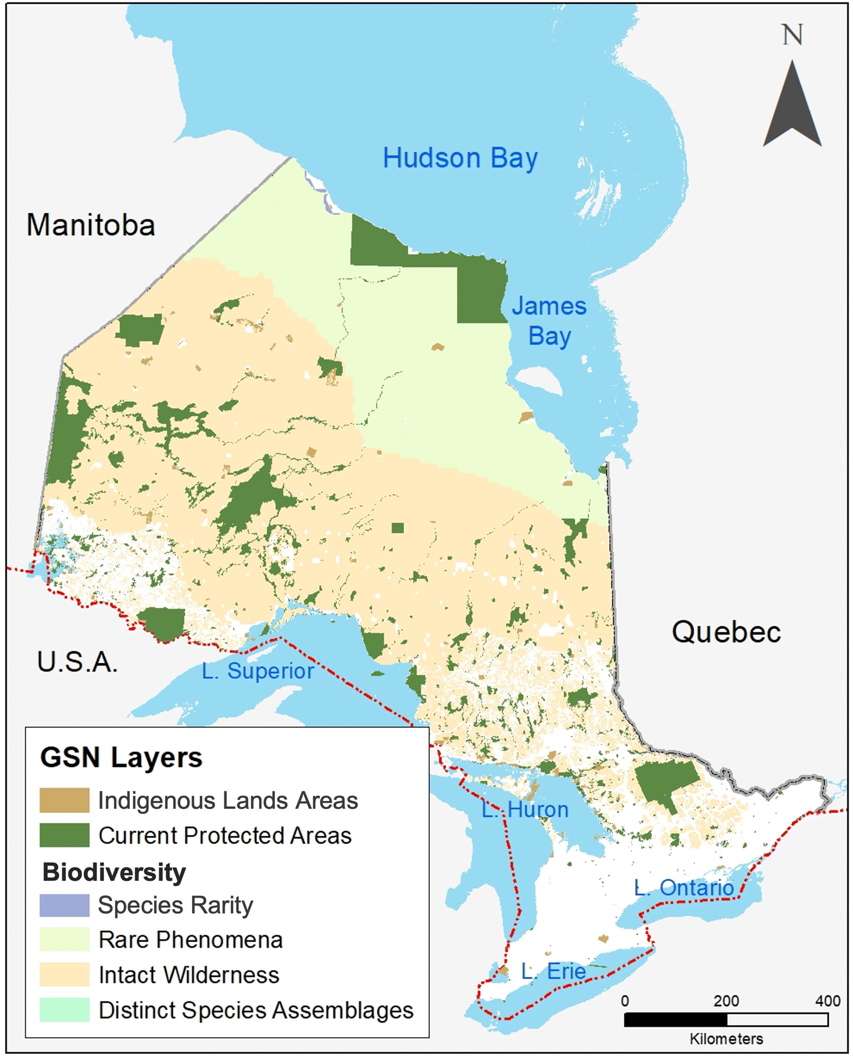
While there are important regions across all of Ontario in terms of carbon stocks and biodiversity, the Far North of the province stands out as particularly significant in the GSN and other global-scale analyses (Soto-Navarro et al. 2020), because of both enormous peatland carbon stocks and roadless areas providing significant wildlife habitat. However, the northern part of Ontario is considered “unmanaged” due to a lack of formal land-use plans, and the extent of formally recognized protected areas is limited (Fig. 1). Although Ontario’s Far North Act enacted in 2010 specified the need to preserve soil carbon stocks and capacity for carbon sequestration in land-use planning decisions, pressures to accelerate road development, mining, and hydroelectric infrastructure in northern Ontario are continuing to intensify. These development proposals have been politically contentious, and the First Nations Chiefs of the Mushkegowuk Council released a statement in 2021 calling for a moratorium on development in the Far North until comprehensive studies are available on the impacts to wetlands if development proceeds, particularly in terms of existing carbon stocks and potential for uptake (Baiguzhiyeva 2021).
Fig. 1.
The GSN is a “top-down” effort to provide objective criteria for prioritizing lands for protection and is intended as a dynamic tool to support land-use planning at national or subnational scales (Dinerstein et al. 2020). With the goal of contributing to the discussion on expanding protection and protected areas in Ontario, we aim here to (i) highlight the areas identified in the GSN as targets for protection in Ontario, (ii) critically analyze the data for Ontario used to delineate these targets in the analyses of Dinerstein et al. (2020), (iii) highlight data needs for assessing the capacity for climate stabilization and biodiversity conservation in Ontario, and (iv) comment on applicability of GSN criteria to conservation planning for Ontario.
Methods: Data handling and mapping
GSN Data
We extracted the eight available layers from the GSN database (Dinerstein et al. 2020). Each GSN layer was uploaded into ArcMap V.10.7 (ESRI, Inc.) and clipped to the shapefile for the Province of Ontario (Government of Ontario GeoHub 2021) using the ArcMap geoprocessing clip function. We exported attribute data including spatial extent (km2) for each layer clipped to Ontario for analysis.
Biodiversity
Dinerstein et al. (2020) first consider biodiversity target areas, using 11 previously compiled datasets to establish four distinct layers related to the following biodiversity criteria for the GSN: rarity, turnover or beta diversity, rare phenomena (large mammal landscapes), and intactness (Table 1). If the original data sources were already in polygon format, then Dinerstein et al. (2020) retained the polygon structure in the GSN. If the original biodiversity data were in a raster format, Dinerstein et al. (2020) used geoprocessing methods to create polygons containing cells that conform to a set of specifications. In this study, we extracted the four biodiversity layers for the Province of Ontario; the GSN database structure is sequential and non-overlapping.
Table 1.
| GSN biodiversity criterion | Definition | Data sources |
|---|---|---|
| Rarity | Species with restricted ranges and (or) low population densities. Datasets focus on vertebrate animals, particularly mammals, birds and amphibians, and land plant species that are part of the integrated Botanical Information and Ecology Network (BIEN) | Endangered species (IUCN, 2022) Rare vertebrate species: (Hill et al. 2019; Pimm et al. 2018) Key Biodiversity Areas (2021) Rare plant species (Enquist et al. 2019) Zero Extinction: zeroextinction.org/ |
| Turnover/beta-diversity | Turnover in community composition over environmental gradients | Biodiversity hotspots (Myers, 2003) Ecoregions with high beta-diversity (Dinerstein et al. 2017) |
| Rare phenomena | Large mammals (>20 kg) | Remaining intact large terrestrial mammal assemblages (Morrison et al. 2007) |
| Intactness | “Wilderness Areas” are defined as the largest polygons within each ecoregion with the lowest 10% of values from the Human Influence Index (HII) The “Last of the Wild” dataset includes the largest intact polygons that comprise the lowest 10% of values from the HII index globally | Wilderness Areas Dataset (Plumptre et al. 2019) Last of the Wild Dataset (Venter et al. 2016) |
Climate stabilization through terrestrial carbon stocks
Dinerstein et al. (2020) estimated carbon stocks for the GSN from satellite-derived rasterized global maps of carbon contents (mass of carbon per unit area) for above- and below-ground plant biomass (Spawn and Gibbs, 2020). Dinerstein et al. (2020) also incorporated soil organic C contents into these estimates using the Global SoilGrids database (Hengl et al. 2017). SoilGrids uses ground data and machine learning to predict key soil properties including bulk density and carbon content (% of dry mass) at standard depths up to 200 cm, for a global grid at 250-m resolution. In Dinerstein et al. (2020), areal soil organic carbon stocks (mass of C per unit area) are estimated using SoilGrids, but only to a depth of 30 cm due to large uncertainties in greater soil depths (Hengl et al. 2017; Soto-Navarro et al. 2020).
In the GSN, Dinerstein et al. (2020) overlaid high carbon storage areas with terrestrial ecoregion and biodiversity polygons to determine areas of overlap providing co-benefits of biodiversity and high carbon storage. Dinerstein et al. (2020) extracted carbon stocks for each grid cell (300 × 300 m) and subsequently computed a median C stock value for each of the terrestrial ecoregions and biodiversity polygons (Tables 2 and 3). Next, Dinerstein et al. (2020) identified areas that do not overlap with biodiversity layers or with existing protected areas but comprise high carbon storage and are needed to reach the GSN goal of 50% land protection in the terrestrial realm. They then created an additional layer to represent these non-overlapping areas that contain high carbon stocks, categorizing high carbon storage areas as “Tier 1” (>215 t/ha of carbon) or “Tier 2” (50–215 t/ha of carbon). In this study, we extracted GSN carbon stock estimates for Ontario ecoregions (defined by the framework of Olson et al. (2001)) and compared and critically assessed these estimates with other available data (Söthe et al. 2022; Tarnocai et al. 2011).
Table 2.
| GSN data layer | Area in the global terrestrial land surface, km2 (% of total) | Area in Canada, km2 (% of Canada’s land surface area) | Area in Ontario, km2 (% of Ontario land surface area) | Proportion of Ontario (%) land surface in global estimates | Proportion of Ontario (%) land surface in Canadian estimates |
|---|---|---|---|---|---|
| Existing terrestrial protected areas | 20,210,878 (15%) | 1,099,380 (11%) | 107,786 (11%) | 0.53 | 9.8 |
| Additional GSN areas for species rarity | 3,047,787 (2.3%) | 33,320 (0.30%) | 725 (<0.001%) | 0.024 | 2.2 |
| Additional GSN areas for distinct species assemblages (beta-diversity) | 8,072,308 (6%) | 0 | 0 | 0 | 0 |
| Additional GSN areas for the rare phenomenon of large mammal landscapes | 8,414,171 (6.3%) | 3,017,810 (30%) | 198,722 (20%) | 2.4 | 6.6 |
| Additional GSN areas for intact wilderness | 21,515,364 (16%) | 3,693,990 (37%) | 546,438 (55%) | 2.5 | 15 |
| Total biodiversity area | 41,049,630 (31%) | 6,745,120 (68%) | 745,884 (75%) | 1.8 | 11 |
| Total area with carbon stocks >215 t/ha | 52,598,352 (39%) | 7,088,453 (71%) | 773,785 (78%) | 1.5 | 11 |
Note: The biodiversity layers are mapped sequentially in the order presented below; any overlap between a new biodiversity data layer and a previous layer is removed to avoid double counting. Canada’s land surface area (9,916,540 km2) was taken from the GSN data appendix (Dinerstein et al. 2020), and Ontario’s land surface area (989,094 km2) was taken from Statistics Canada (2011).
Table 3.
| Ecoregion of Ontario | Median total carbon content (t/ha) specified in the GSNa,c | Range of soil organic carbon content in peatlands only (t/ha) (Tarnocai et al. 2011)b | Mean above- and below-ground carbon content in plants (t/ha) (Söthe et al. 2022)c | Mean total soil carbon content (t/ha), to 1 m depth (Söthe et al. 2022)c | Mean total soil carbon content (t/ha), to 2 m depth (Söthe et al. 2022)c |
|---|---|---|---|---|---|
| Northern Ontario ecoregions | |||||
| Southern Hudson Bay Taiga | 1586 | 1000–1600 | 31.5 | 1045 | 2072 |
| Central Canadian Shield forests | 412 | 1000–2000 | 52.1 | 585 | 1138 |
| Midwestern Canadian Shield forests | 570 | 1600–2500+ | 52.2 | 663 | 1292 |
| Central-Southern Ontario ecoregions | |||||
| Western Great Lakes Forests | 271 | 1800–2000 | 61.2 | 199 | 306 |
| Eastern Forest boreal Transition | 353 | Not estimated | 64.4 | 236 | 396 |
| Eastern Great Lakes Lowland forests | 253 | Not estimated | 14.9 | 233 | 405 |
| Southern Great Lakes Forests | Not estimated (<50) | Not estimated | 13.4 | 211 | 357 |
a
Composite of above-, below-ground plants and soil estimates derived from Hengl et al. (2017) and Spawn and Gibbs (2020). Ecoregions are defined following the Terrestrial Ecosystems of the World Map of Olson et al. (2001).
b
These estimates are for peatlands only. Only a portion of each ecoregion is defined as peatland. These peatland soil carbon stock estimates include the whole peat profile down to mineral substrate (Tarnocai et al. 2011).
c
Median/means for the whole of each ecoregion, including peatlands and non-peatlands.
Indigenous lands and existing protected areas
Dinerstein et al. (2020) mapped Indigenous lands using the dataset of Garnett et al. (2018) and mapped existing protected areas using the World Database of Protected Areas (WDPA 2018) in the GSN. The dataset used to specify Indigenous lands for Canada in Garnett et al. (2018) includes only surrendered lands, reserves, and settled land claims (Natural Resources Canada 2017). In our study, we extracted Indigenous lands and protected areas for Ontario from the GSN and considered how these compare to larger areas corresponding to traditional lands of Indigenous Nations (Native Land Digital 2022).
Results
Fifty of the 846 global terrestrial ecoregions (Olson et al. 2001) and 20 countries, including Canada, which is the second largest country in the world by land area, contribute disproportionately to the additional lands proposed for protection in the GSN framework (Dinerstein et al. 2020). In Ontario, the majority of the province’s land surface (78%) (Table 2) meets the threshold for climate stabilization because of carbon content far exceeding the median value of 215 t/ha for the 846 global terrestrial ecoregions. Further, the majority of the province’s land surface (75%) also meets the criteria for intactness and the rare ecological phenomenon of large mammal landscapes with the northern half of Ontario standing out as strongly significant for these criteria. The proportion of the total global area identified in the GSN for biodiversity located in Ontario (1.8%) is more than double that of Ontario’s proportion of land surface area relative to the global total (0.8%). Across the province, 96% of the area identified for climate stabilization overlaps with the lands highlighted by the biodiversity criteria. These lands also correspond to the largest carbon stocks in the province and thus offer enormous potential, if adequately and ethically protected, to address climate stabilization and biodiversity conservation.
Key findings on biodiversity
Intactness is the criterion driving the largest land areas specified for protection under the GSN globally (Table 2); the largest areas meeting the specified criteria for “intactness” are in the circum-boreal regions of Canada and Russia, and they often lack formal protection (Dinerstein et al. 2020). Ontario particularly stands out in the “intactness” criterion, which covers 55% of its land surface and is a markedly higher proportion than for Canada as a whole (37%) (Table 2). The regions scoring high on “intactness” also often overlap with ranges of large mammals, which is captured in the GSN criterion of rare ecological phenomena. Canada ranks second after Russia in the list of countries with highest potential for meeting GSN targets by adding new protections on lands scoring high on “intactness” and rare ecological phenomena. This latter criterion refers solely in the GSN to landscapes associated with ranges of large mammals (defined as > 20 kg in body mass). In Ontario, this includes several mammals of interest for conservation or management such as wolves (Canis lupus), caribou (Rangifer tarandus), polar bear (Ursus maritimus), moose (Alces alces), or wolverine (Gulo gulo) (Abraham et al. 2011; Dobbyn 1994; Far North Science Advisory Panel 2010).
Of the four biodiversity criteria used in the GSN, species rarity resulted in the smallest specified land area globally (Table 2; Dinerstein et al. 2020). This is mirrored in the results for Canada, which accounts for about 1% of global land areas specified using this criterion. Of Canada’s total land areas identified as important for the species rarity criterion, 2.2% are in Ontario (Table 2). In the GSN analyses, these are mainly associated with essential polar bear and caribou habitat; both are considered vulnerable mammals on the IUCN Red List (IUCN 2022). The areas identified in the GSN in Ontario for the species rarity criterion appear to be derived from coastal areas in Ontario’s Far North specified in the Key Biodiversity Areas (KBA) dataset, including Niskibi Cape, Severn River Coastline, Akimiski Strait, Big Piskwanish Point, Longridge Point, and Hannah Bay (Key Biodiversity Areas 2021). These areas include calving ground on the James and Hudson Bay coasts for woodland caribou, the Pen Islands which hold 30–40% of Ontario’s summering polar bear population, and essential migratory shorebird stopover sites (Abraham et al. 2011; Key Biodiversity Areas 2021; Macdonald et al. 2021). Lastly, the beta diversity (species turnover) criterion resulted in the specification of 6% of global land areas but did not result in any specified areas in Ontario (Table 2).
Key findings on carbon
The GSN analysis corroborates many other studies indicating that Canada’s lands contain globally significant carbon stocks (i.e., Packalen et al. 2014; Söthe et al. 2022). In Ontario, 96% of the areas that are identified as important for biodiversity are also identified in the GSN as Tier 1 climate stabilization areas storing >215 t/ha of carbon. Moreover, most of Ontario is considered a high carbon storage area in the GSN (categorized as “Tier 1” i.e., >215 t/ha) with the highest carbon contents per unit area located in the northern half of the province (Fig. 2). Northern Ontario ecoregions include the Hudson Bay Lowlands taiga, Midwestern Canadian Shield, and Central Canadian Shield forest Ecoregions; all are associated with the highest median carbon stock values for Ontario in the GSN framework (Fig. 2; Table 3). The Hudson Bay Lowlands taiga ranks fourth in the world using these data sources for estimated total carbon stock (behind the East/West Siberian and Russian Taiga Ecoregions).
Fig. 2.
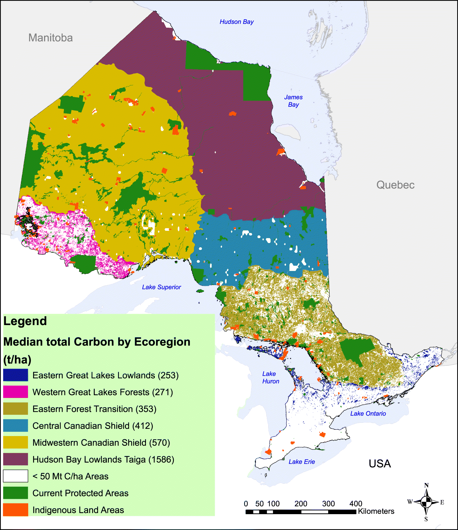
For northern Ontario ecoregions, the total carbon stock is primarily composed of soil carbon (Scharlemann et al. 2014). The significance of soil carbon stocks in northern boreal ecosystems in Ontario has also been shown in the national peatland inventory for Canada (Tarnocai et al. 2011), recent syntheses (Harris et al. 2021), and predictive total carbon mapping products derived from combined field measurements, satellite remote sensing, climate and topographic data, and (or) machine learning algorithms (McLaughlin and Packalen 2021; Söthe et al. 2022). Using this latter approach for Ontario, Söthe et al. (2022) estimate carbon stock values for the Hudson Bay Lowlands taiga ecoregion that are similar to those specified in the GSN but markedly higher values for the remaining northern Ontario ecoregions (Table 3).
Indigenous lands
Globally, 35% of the land area that is specified by the GSN as critical for biodiversity or climate stabilization overlaps with Indigenous lands (Dinerstein et al. 2020). Of the 8,827 km2 Indigenous lands officially recognized in Ontario (Natural Resources Canada 2017), <0.1% encompass protected areas while more than half are specified as important for biodiversity conservation and carbon storage by the GSN. Because the officially recognized Indigenous lands in Canada do not account for unceded lands and the actual traditional territories that continue to be managed and lived in by Indigenous people today (Native Land Digital 2022), the GSN values vastly underestimate the overlap between areas of highest conservation value and Indigenous managed lands in Ontario.
Protected areas
At the time of the publication of the datasets used in the GSN, about 11% of Canada’s land area was formally protected, with a similar portion in Ontario (Table 2). Since then, some additional protected areas have been established, bringing the total to approximately 14% (Environment and Climate Change Canada 2021). The GSN criteria identify >750,000 km2 or 75% of the land surface of Ontario as part of the proposed global framework for protected areas needed to prevent further biodiversity losses and stabilize climate.
Discussion
The GSN framework uses broad criteria to identify 50% of global lands to halt catastrophic biodiversity losses and stabilize the climate (Dinerstein et al. 2020). These criteria resulted in the identification of the majority of Ontario’s land surface as part of the GSN framework to meet the stated targets of identifying 50% of Earth’s land surface area for enhanced protection. Ontario covers 0.8% of the global land surface area but represents 1.8% of the lands identified as essential for protection, showing an outsized role of Ontario in addressing the climate and biodiversity crises. Yet, the GSN framework as applied to Ontario does not directly contribute to the identification of specific places to prioritize for protection simply because the general criteria encompass most of the province’s land surface and are not ideally suited to Ontario.
Although it is unfeasible from political or socio-economic standpoints to establish formally protected areas across such a large swath of the province, protective measures can still be conferred where development has or is occurring to limit and manage cumulative impacts. The GSN results for Ontario strongly underline the enormous significance of the province from these perspectives, and the extent to which the expansion of protection measures in Ontario will have global benefits for conservation and climate stability. The approach used in the GSN also offers an opportunity to critically evaluate the data used for Ontario and identify gaps that may help inform future decisions on conservation.
Roadless wilderness
Ontario stands out in the results for its very large portion of lands scoring high on the intactness criterion. These vast and roadless “wilderness” areas cover more than half of the province (Fig. 1) and provide critical habitat to maintain animal populations, and refugia for threatened species, because of the excellent habitat connectivity and low rates of fragmentation (Dietz et al. 2021). Globally, un-fragmented wilderness areas have been in precipitous decline, although many regions of Canada, including the boreal forests and peatlands in northern Ontario, stand out in several global syntheses for remaining relatively intact (Humpenöder et al. 2020; Watson et al. 2016). However, the assumption that there are no substantive threats to the roadless areas of Ontario is no longer valid due to climate change and many recent proposals for development including mining, hydroelectricity, roads, and agriculture (Harris et al. 2021). Furthermore, the “wilderness” narrative undermines the long-standing presence of First Nations, which have stewarded these lands for thousands of years and continue to do so today (Youdelis et al. 2020). Ongoing policy discussions on land-use planning in the “unmanaged” portion of Ontario must include Indigenous rights as well as consideration of the global ecological significance of this region.
Peatlands and carbon storage
A second key finding from our analysis is that the majority of Ontario is classified using GSN criteria as important for climate stabilization owing to large carbon stocks in soils and biomass. The GSN data align with other recent estimates of total carbon stocks by ecoregion (Söthe et al. 2022) in identifying the Southern Hudson Bay taiga as by far Ontario’s most important region from the perspective of existing carbon stocks with an order of magnitude greater than the global median (Table 3). This ecoregion consists of an extensive mostly contiguous peatland with an average peat depth of 2.5 m (Packalen et al. 2016) and carbon stock of ∼30 Gt (Packalen et al. 2014). Given the vulnerability of this vast “irrecoverable” soil carbon stock (Harris et al. 2021; Noon et al. 2022) to disturbance, our analyses of the GSN and related data strongly point to this region as a highest priority for protection. However, our analyses further show that more region-specific ground data are needed to make accurate estimates, particularly concerning peatland distributions and depths of organic soils where the largest carbon stocks are held. While the GSN data capture the importance of the Southern Hudson Bay taiga in terms of existing carbon stocks reasonably well (Table 3), it significantly underestimates stocks in other ecoregions of Ontario. For example, Tarnocai et al. (2011) and, more recently, Söthe et al. (2022) show the significance of the Mid- and Central Canadian Shield forests in terms of soil carbon stocks using region-specific field measurements. In the GSN, the soil carbon stocks in forested and open peatlands of these parts of the boreal biome are underestimated and inaccurate due to a paucity of field measurements on peat or organic soil depth (Beaulne et al. 2021). Overall, more field measurements are needed to better constrain peatland carbon stocks and improve existing models of greenhouse gas fluxes for up-scaling peatland carbon budgets to ecoregion scales (Bona et al. 2020).
In addition to recommending the collection of additional ground data for soil carbon stocks in northern Ontario ecoregions, particularly forested peatlands, our analysis of GSN framework also highlights the need to focus on other criteria for identifying protected areas within the extensive unmanaged lands of northern Ontario. These criteria could include, for example, identification of areas with both high existing soil carbon stocks and ongoing net carbon sink capacities over short- and medium-term time frames, areas of hydrologic and biogeochemical connectivity, headwater regions to prevent downstream effects, or peatland areas with mercury reservoirs that are vulnerable to methylation (Kirkwood et al. 2021; Mitchell et al. 2008).
Indigenous-led conservation
Globally, an important fraction of the areas targeted in the GSN for protection is Indigenous land (Dinerstein et al. 2020). However, maps produced by ruling governments often do not reflect what Indigenous people consider their traditional territories, nor do they reflect management and conservation efforts either ongoing or in the past by Indigenous peoples (Garnett et al. 2018). For example, the Southern Hudson Bay taiga ecoregion, which is the most significant in Ontario in terms of carbon stocks, includes the traditional lands of the Omushkego Cree Nations. These nations hold deep connections and traditional knowledge of these lands, and many also share an interest in conservation and sustainable management of their traditional lands in northern Ontario to support biodiversity and climate protection (e.g., Timmins Daily Press 2021). While the datasets of Garnett et al. (2018) and Dinerstein et al. (2020) do not capture the significant extent of Indigenous-led conservation already underway in Canada, our analysis underscores the potential to meet stated goals of reconciliation and conservation through facilitation of existing and new proposals for Indigenous Protected and Conserved Areas (IPCAs), which support formal protection of lands long stewarded by Indigenous people in northern Ontario (Zurba et al. 2019). These include, for example, proposals for IPCAs in Kah-Pana-Yow Sîpi (North French River Watershed) in northeastern Ontario or on the traditional lands of the Kitchenuhmaykoosib Inninuwug First Nations in northwestern Ontario (Talaga 2019). Because of the correspondence between areas of interest for conservation and the traditional lands of Indigenous people in Ontario and elsewhere, implementation of IPCAs is a necessary approach to upholding treaty rights and ethically reaching conservation goals (Artelle et al. 2019).
Limitations of GSN
In addition to the limitations specified above, the GSN framework has other constraints in terms of its applicability to Ontario. Firstly, the GSN focuses on terrestrial biodiversity (mammals and plants) and does not capture freshwater nor marine ecosystems which are highly significant in Ontario. Freshwater ecosystems are experiencing high rates of biodiversity loss in many regions, yet they have more rarely been integrated into conservation planning (Southee et al. 2021). In Ontario, freshwater fish have high cultural and economic significance, and some iconic species are highly threatened, resulting in calls for a focus on “freshwaterscapes” in discussion of conservation priorities (McDermid et al. 2015). In addition, marine environments contain significant large mammals species (> 20 kg) that could be incorporated into the GSN “rare phenomena” criteria, including the protection of seal, walrus, and whale populations (Dobbyn 1994). The James and Hudson Bay coasts in Ontario’s Far North will be subject to a feasibility study for the establishment of a National Marine Conservation Area (pc.gc.ca/en/amnc-nmca/cnamnc-cnnmca/jamesouest-westernjames) which will contribute to the protection of marine and coastal species, as well as blue carbon stocks in the tidal and freshwater marshes of the coastal zone (Riley 2011).
Secondly, the absence of species rarity areas in Southern Ontario highlights an important shortcoming of the application of the GSN criteria. Southern Ontario has the highest concentration of species richness and number of threats to biodiversity of any area in Canada, particularly in the Carolinian Zone (Kraus and Hebb 2020; Riley 2013), and supports several KBAs (Key Biodiversity Areas 2021). Yet, the GSN approach explicitly excludes areas of high human population density and agricultural lands. Consequently, the GSN framework did not identify areas for conservation of species rarity in Southern Ontario where >60% of Canada’s species at risk are found (Kraus and Hebb 2020) and negates important conservation opportunities in populated regions of Southern Ontario. More work is necessary for identifying priority areas and expanding KBAs (as is now being done in Canada; kbacanada.org) and protection in regions where higher human populations and critical habitat for rare and threatened species are present. This could also be further aided by examining the absolute (instead of sequential) values mapped for each biodiversity layer and collecting more data on beta diversity (species turnover) to improve interpretations on regional scales. In short, our analysis of GSN data as applied to Ontario shows some limitations in terms of both the GSN criteria themselves and the data available for those criteria, for conservation planning in Ontario. Despite those limitations, the GSN framework nonetheless highlights the global significance of Ontario.
Conclusions and recommendations
The GSN framework is global in scale and relies considerably on large intact wilderness areas in the boreal biome to achieve the target of 50% of protected global lands. There are many compelling reasons to protect large swaths of roadless boreal forest and peatlands; however, the GSN framework when scaled down to a jurisdiction such as Ontario has limitations in terms of identifying specific areas to prioritize for conservation and also discounts the opportunities for biodiversity conservation and climate stabilization in less intact regions. Despite these limitations, the GSN results for Ontario highlight the global significance of its conservation decisions.
Dinerstein et al. (2020) call for leadership from local jurisdictions and we urge Ontario to enhance protection for lands that are critical to climate stabilization and the protection of biodiversity. Ontario stewards one of the largest natural carbon stocks globally, because of the abundant peatlands and boreal forests of the Far North. Ontario is also a key area for the biodiversity criteria used in the GSN, namely the extensive lands scoring high on “intactness” in the northern half of the province. The large overlap between lands identified for biodiversity as well as climate stabilization in the GSN highlights important opportunities for protected areas in Ontario, particularly in the Far North. These lands also correspond to the traditional territories of the Mushkegowuk and Matawa Nations, which have been stewarding these vast “intact” ecosystems for thousands of years. The formally recognized extent of Indigenous lands in Ontario does not reflect actual traditional territories and is greatly limited in terms of overlap with lands supporting vital wildlife habitat and significant carbon stocks. This has contributed to the inadequate consultation and representation of First Nations, Métis, and Inuit in national conservation planning.
Our analysis of GSN data as applied to Ontario results in several recommendations. In terms of biodiversity, we support previous work showing the importance of broadening criteria for identifying protected areas, including freshwater and marine ecosystems (Southee et al. 2021), and the need to identify areas of species rarity and high beta-diversity or species turnover along environmental gradients in Ontario. On the carbon side, our recommendations include further developing high-resolution spatial representations of both carbon stocks and sinks, with a focus on soils and peatlands for northern Ontario ecoregions. Additionally, more work is needed to quantify the vulnerability of biodiversity and existing carbon stocks and sinks to climate warming and increasing risk of wildfire, as well as land-use change, road development, and resource extraction. Owing to the complexity of land use and conservation planning in these regions, it is imperative that treaty rights are respected, and First Nations have the opportunity to make decisions regarding land use on their traditional lands.
Acknowledgments
We thank the Mushkegowuk Council and community members for stewardship of their traditional lands, and commitment to ensuring their protection. We acknowledge the Mushkegowuk Lands and Resources Terrestrial Working Group members for many helpful discussions on the topics discussed here. We thank Karl Burkhart for assistance with GSN data, Camile Söthe and Alemu Gonsamo (McMaster University) for providing carbon stock estimates by ecoregion, and Xiaoyuan Guan (Agriculture and Agri-Food Canada) for helpful discussions on soil carbon stock estimations. We also thank Dr Justina Ray and an anonymous reviewer for comments which improved the paper.
Competing interest statement
The authors declare there are no competing interests.
References
Abraham KF, McKinnon LM, Jumean Z, Tully SM, Walton LR, and Stewart HM. 2011. Hudson Plains Ecozone+ Status and Trends Assessment. Canadian Biodiversity: Ecosystem Status and Trends, Canadian Councils of Resource Ministers, Ottawa, Ontario, Canada, p. xxi + 445 pp.
Artelle KA, Zurba M, Bhattacharyya J, Chan DE, Brown K, Housty J, and Moola F. 2019. Supporting resurgent Indigenous-led governance: A nascent mechanism for just and effective conservation. Biological Conservation, 240: 108284.
Baiguzhiyeva D. 2021. Mushkegowuk chiefs call for moratorium on Ring of Fire development [online]: Available from thestar.com/news/canada/2021/01/13/mushkegowuk-chiefs-call-for-moratorium-on-ring-of-fire-development.html
Beaulne J, Garneau M, Magnan G, and Boucher É. 2021. Peat deposits store more carbon than trees in forested peatlands of the boreal biome. Scientific Reports, 11: 2657.
Bona KA, Shaw C, Thompson DK, Hararuk O, Webster K, Zhang G, Voicu M, and Kurz WA. 2020. The Canadian model for peatlands (CaMP): A peatland carbon model for national greenhouse gas reporting. Ecological Modelling, 431: 109164.
Dietz MS, Barnett K, Belote RT, and Aplet GH. 2021. The importance of U.S. national forest roadless areas for vulnerable wildlife species. Global Ecology and Conservation, 32: e01943.
Dinerstein E, Olson D, Joshi A, Vynne C, Burgess ND, Wikramanayake E, et al. 2017. An Ecoregion-Based Approach to Protecting Half the Terrestrial Realm. Bioscience, 67: 534–545.
Dinerstein E, Vynne C, Sala E, Joshi AR, Fernando S, Lovejoy TE, et al. 2019. A Global Deal For Nature: Guiding principles, milestones, and targets. Science Advances, 5: eaaw2869.
Dinerstein E, Joshi AR, Vynne C, Lee ATL, Pharand-Deschênes F, França M, et al. 2020. A “Global Safety Net” to reverse biodiversity loss and stabilize Earth’s climate. Science Advances, 6: eabb2824.
Dobbyn JS. 1994. Atlas of the Mammals of Ontario. Federation of Ontario Naturalists, Don Mills, Ontario.
Enquist BJ, Feng X, Boyle B, Maitner B, Newman EA, Jørgensen PM, et al. 2019. The commonness of rarity: Global and future distribution of rarity across land plants. Science Advances, 5: eaaz0414.
Environment and Climate Change Canada. 2021. Canadian Environmental Sustainability Indicators: Canada’s conserved areas. [online]: Available from canada.ca/en/environment-climate-change/services/environmental-indicators/conserved-areas.html
Far North Science Advisory Panel. 2010. Science for a Changing North: Report to the Ontario Ministry of Natural Resources. The Queen’s Printer for Ontario, Toronto.
Garnett ST, Burgess ND, Fa JE, Fernández-Llamazares Á, Molnár Z, Robinson CJ, et al. 2018. A spatial overview of the global importance of Indigenous lands for conservation. Nature Sustainability, 1: 369–374.
Government of Ontario GeoHub 2021. Province of Ontario Shapefile. [online]: Available from ontario.ca/page/land-information-ontario,
Harris LI, Richardson K, Bona KA, Davidson SJ, Finkelstein SA, Garneau M, et al. 2021. The essential carbon service provided by northern peatlands. Frontiers in Ecology and the Environment, 4: 222–230.
Hengl T, Mendes de Jesus J, Heuvelink GBM, Ruiperez Gonzalez M, Kilibarda M, Blagotić A, et al. 2017. SoilGrids250m: Global gridded soil information based on machine learning. PloS ONE, 12: e0169748.
Hill SLL, Arnell A, Maney C, Butchart SHM, Hilton-Taylor C, Ciciarelli C, et al. 2019. Measuring Forest Biodiversity Status and Changes Globally. Frontiers in Forests and Global Change, 2.
Holmquist JR, and MacDonald GM. 2014. Peatland succession and long-term apparent carbon accumulation in central and northern Ontario, Canada. Holocene, 24: 1075–1089.
Humpenöder F, Karstens K, Lotze-Campen H, Leifeld J, Menichetti L, Barthelmes A, and Popp A. 2020. Peatland protection and restoration are key for climate change mitigation. Environmental Research Letters, 15: 104093.
IUCN. 2022. The IUCN red list of threatened species. Version 2021-3. [online]: Available from iucnredlist.org,
Key Biodiversity Areas. 2021. Key Biodiversity Areas Data Dashboard, 2021-11. [online]. Available from keybiodiversityareas.org/kba-data,
Kirkwood AH, Roy-Léveillée P, Branfireun BA, and Basiliko N. 2021. Mercury, Methylmercury, and Microbial Communities in a Degrading Palsa of the Hudson Bay Lowlands, Far North Ontario. In Permafrost 2021: Merging Permafrost Science and Cold Regions Engineering. Edited by J Zufelt, American Society of Civil Engineers, Reston, Virginia, pp. 49–59. [online]: Available from ascelibrary.org/doi/abs/10.1061/9780784483589.005
Kraus D, and Hebb A. 2020. Southern Canada’s crisis ecoregions: identifying the most significant and threatened places for biodiversity conservation. Biodiversity and Conservation, 29: 3573–3590.
Long JS. 2010. Treaty No. 9. McGill-Queen’s University Press, Montreal.
Macdonald AJ, Smith PA, Friis CA, Lyons JE, Aubry Y, and Nol E. 2021. Stopover ecology of red knots in southwestern James Bay during southbound migration. Journal of Wildlife Management, 85: 932–944.
McDermid J, Browne D, Chetkiewicz CL, and Chu C. 2015. Identifying a suite of surrogate freshwaterscape fish species: a case study of conservation prioritization in Ontario’s Far North, Canada. Aquatic Conservation-Marine and Freshwater Ecosystems, 25: 855–873.
McLaughlin JW, and Packalen MS. 2021. Peat carbon vulnerability to projected climate warming in the Hudson Bay lowlands, Canada: A decision support tool for land use planning in peatland dominated landscapes. Frontiers in Earth Science, 9.
Mitchell CPJ, Branfireun BA, and Kolka RK. 2008. Spatial characteristics of net methylmercury production hot spots in peatlands. Environmental Science, and Technology, 42: 1010–1016.
Morrison JC, Sechrest W, Dinerstein E, Wilcove DS, and Lamoreux JF. 2007. Persistence of large mammal faunas as indicators of global human impacts. Journal of Mammalogy 88: 1363–1380.
Myers N. 2003. Biodiversity hotspots revisited. Bioscience, 53: 676–917.
Native Land Digital. 2022. [online]: Available from native-land.ca/
Natural Resources Canada 2017. Aboriginal lands of Canada legislative boundaries [online]: Available from: open.canada.ca/data/en/dataset/522b07b9-78e2-4819-b736-ad9208eb1067
Noon ML, Goldstein A, Ledezma JC, Roehrdanz PR, Cook-Patton SC, Spawn-Lee SA, et al. 2022. Mapping the irrecoverable carbon in Earth’s ecosystems. Nature Sustainability, 5: 37–46.
O’Bryan CJ, Garnett ST, Fa JE, Leiper I, Rehbein JA, Fernández-Llamazares Á, et al. 2021. The importance of indigenous Peoples’ lands for the conservation of terrestrial mammals. Conservation Biology, 35: 1002–1008.
Olson DM, Dinerstein E, Wikramanayake ED, Burgess ND, Powell GVN, Underwood EC, et al. 2001. Terrestrial ecoregions of the world: A new map of life on earth. Bioscience, 51: 933–938.
Packalen MS, Finkelstein SA, and McLaughlin JW. 2014. Carbon storage and potential methane production in the Hudson Bay Lowlands since mid-Holocene peat initiation. Nature Communications, 5.
Packalen MS, Finkelstein SA, and McLaughlin JW. 2016. Climate and peat type in relation to spatial variation of the peatland carbon mass in the Hudson Bay Lowlands, Canada. Journal of Geophysical Research-Biogeosciences, 121: 1104–1117.
Pimm SL, Jenkins CN, and Li BV. 2018. How to protect half of Earth to ensure it protects sufficient biodiversity. Science Advances, 4: eaat2616.
Plumptre AJ, Baisero D, Jędrzejewski W, Kühl H, Maisels F, Ray JC, et al. 2019. Are we capturing faunal intactness? A comparison of intact forest landscapes and the “last of the wild in each ecoregion”. Frontiers in Forests and Global Change, 2.
Riley JL. 2011. Wetlands of the Ontario Hudson Bay Lowland: A Regional Overview. Nature Conservancy of Canada, Toronto.
Riley JL. 2013. The once and future Great Lakes country: An ecological history. McGill-Queens University Press, Montreal.
Scharlemann JPW, Tanner EVJ, Hiederer R, and Kapos V. 2014. Global soil carbon: understanding and managing the largest terrestrial carbon pool. Carbon Management, 5: 81–91.
Schuster R, Germain RR, Bennett JR, Reo NJ, and Arcese P. 2019. Vertebrate biodiversity on indigenous-managed lands in Australia, Brazil, and Canada equals that in protected areas. Environmental Science, and Policy, 101: 1–6.
Söthe C, Gonsamo A, Arabian J, Kurz WA, Finkelstein SA, and Snider J. 2022. Large soil carbon storage in terrestrial ecosystems of Canada. Global Biogeochemical Cycles, e2021GB007213.
Soto-Navarro C, Ravilious C, Arnell A, de Lamo X, Harfoot M, Hill SLL, et al. 2020. Mapping co-benefits for carbon storage and biodiversity to inform conservation policy and action. Philosophical Transactions of the Royal Society B: Biological Sciences, 375: 20190128.
Southee F, Edwards B, Chetkiewicz C-LB, O’Connor CM, and Favaro B. 2021. Freshwater conservation planning in the far north of Ontario, Canada: identifying priority watersheds for the conservation of fish biodiversity in an intact boreal landscape. FACETS, 6: 90–117.
Spawn SA, and Gibbs HK. 2020. Global aboveground and belowground biomass carbon density maps for the year 2010, ORNL distributed active archive center [online]: Available from daac.ornl.gov/cgi-bin/dsviewer.pl?ds_id=1763
Statistics Canada. 2011. Cartographic boundary files. [online]: Available from www12.statcan.gc.ca/census-recensement/2011/geo/bound-limit/bound-limit-2011-eng.cfm
Talaga T. 2019. It’s time to permanently protect 1.3M hectares of ‘breathing lands’. The Toronto Star [online]: Available from thestar.com/politics/political-opinion/2019/08/21/its-time-to-permanently-protect-13m-hectares-of-breathing-lands.html
Tarnocai C, Kettles IM, and Lacelle B. 2011. Peatlands of Canada. Geological Survey of Canada, 6561.
Timmins Daily Press. 2021. Mushkegowuk chiefs call for moratorium on development within Ring of Fire [online]: Available from timminspress.com/news/local-news/mushkegowuk-chiefs-call-for-moratorium-on-development-within-ring-of-fire
Townsend J, Moola F, Craig M-K, and Lesbarrères D. 2020. Indigenous Peoples are critical to the success of nature-based solutions to climate change. FACETS, 5: 551–556.
Venter O, Sanderson EW, Magrach A, Allan JR, Beher J, Jones KR, et al. 2016. Sixteen years of change in the global terrestrial human footprint and implications for biodiversity conservation. Nature Communications, 7: 12558.
Watson JEM, Shanahan DF, Di Marco M, Allan J, Laurance WF, Sanderson EW, et al. 2016. Catastrophic Declines in Wilderness Areas Undermine Global Environment Targets. Current Biology, 26: 2929–2934.
WDPA. 2018. World database on protected areas. [online]: Available from iucn.org/theme/protected-areas/our-work/world-database-protected-areas
Wilson EO. 2016. Half-Earth: Our Planet’s Fight for Life. Liveright Publishing Corporation, a division of W.W. Norton, and Company, New York.
Youdelis M, Nakoochee R, O’Neil C, Lunstrum E, and Roth R. 2020. “Wilderness” revisited: Is Canadian park management moving beyond the “wilderness” ethic? The Canadian Geographer/Le Géographe canadien, 64: 232–249.
Zurba M, Beazley KF, English E, and Buchmann-Duck J. 2019. Indigenous Protected and Conserved Areas (IPCAs), Aichi Target 11 and Canada’s Pathway to Target 1: Focusing Conservation on Reconciliation. Land, 8: 10.
Information & Authors
Information
Published In
FACETS
Volume 8 • Number 1 • January 2023
Pages: 1 - 17
Editor: Clément pierre Bataille
History
Received: 28 May 2022
Accepted: 2 December 2022
Version of record online: 16 March 2023
Copyright
© 2023 Finkelstein et al. This work is licensed under a Creative Commons Attribution 4.0 International License (CC BY 4.0), which permits unrestricted use, distribution, and reproduction in any medium, provided the original author(s) and source are credited.
Data Availability Statement
This paper does not report new data. All data have been previously published, are publicly available, and are cited in the text.
Key Words
Sections
Subjects
Authors
Author Contributions
All conceived and designed the study.
CD and ALL performed the experiments/collected the data.
All analyzed and interpreted the data.
SAF contributed resources.
All drafted or revised the manuscript.
Funding Information
This research was funded by the Natural Sciences and Engineering Research Council of Canada (Grant no: RGPIN-2017-06759).
Metrics & Citations
Metrics
Other Metrics
Citations
Cite As
Sarah A Finkelstein, Cathal Doherty, and Amanda L. Loder. 2023. Safety Net Ontario: Ontario’s outsized role in the “Global Safety Net” for climate and biodiversity. FACETS.
8(): 1-17. https://doi.org/10.1139/facets-2022-0126
Export Citations
If you have the appropriate software installed, you can download article citation data to the citation manager of your choice. Simply select your manager software from the list below and click Download.
There are no citations for this item